Bertha (Perth)
| Designations | |
|---|---|
| Official name | Bertha, Roman Fort |
| Type | Roman: fort |
| Designated | 17 March 1964 |
| Reference no. | SM2403 |
Bertha is the name of the site of a Roman fort north of the city of modern Perth, Scotland, at the confluence of the rivers Almond and Tay. It is 0.5 miles (0.80 km) east of the modern farm of "Berthapark" and is a scheduled monument.[1]
Name
The name "Bertha" was originally used by medieval Scots historians, such as John of Fordun and Walter Bower, who did not know the original name for the site and who adapted a version of Perth – "Berth". According to the 2nd century AD geographer Ptolemy, the Romans may have called the site Tamia (or possibly Tavus), after a native name for the River Tay.[2][3] In early medieval times the abandoned site was still used for ceremonial purposes by Pictish and Gaelic kings, when it was called "Rathinveramon".[4]
Roman history
The fort was a supply base built around AD 83 to support the occasional Roman expeditions into north-east Scotland. At that time, it was at the highest navigable point on the Tay.[5] It was one of the sites in the series of Roman fortifications known as the Gask Ridge. It is possible that the site was re-used on three occasions up to the 3rd century.[6]
The 9-acre (36,000 m2) site was identified in the 18th century. It has been damaged by river erosion and by ploughing, but excavations in 1973 revealed a ditch 11 feet (3.4 m) wide and 5.5 feet (1.7 m) deep. Immediately within the ditch was a wide berm over 30 feet (9.1 m) wide and this was backed by a turf rampart averaging about 21 feet (6.4 m) wide.[6] Further field studies were reported in 2006 as part of the Roman Gask Project.[7][8]
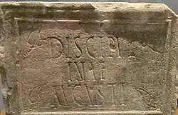
A Roman Altar Stone, inscribed DISCIPVLINA AVGUSTI 'To the discipline of the emperor' was found at the Bertha site near the River Almond in 1958. The cult of military discipline was strongly favored by Hadrian and other emperors from the 2nd century AD onwards. As of June 2025, the stone is on display in the Perth Museum.[9]
Bertha Park, a mixed-use area to the north of Perth's city centre, preserves the name.[10]
References
- ^ Historic Environment Scotland. "Bertha, Roman fort (SM2403)". Retrieved 15 February 2019.
- ^ "Ba to Bo". www.romanplaces.eu. Retrieved 17 July 2025.
- ^ Rivet, A.L.F. and Smith, C. (1979). The Place-Names of Roman Britain. Princeton University Press. p. 470. ISBN 0-691-03953-4.
{{cite book}}: CS1 maint: multiple names: authors list (link) - ^ "Perth and Bertha". Senchus - Notes on early medieval Scotland. Retrieved 14 September 2009.
- ^ "Perth". Undiscovered Scotland. 2000–2009. Retrieved 14 September 2009.
- ^ a b "Bertha, Perth, Tayside". Roman Fort and Camps. 27 January 2016. Archived from the original on 1 March 2019. Retrieved 16 March 2016.
- ^ Woolliscroft, D.J. and Hoffmann, B. (2006). Rome's First Frontier. Tempus. pp. 144–147.
{{cite book}}: CS1 maint: multiple names: authors list (link) - ^ "The Roman Gask Project | A long term research project to study the Romans north of the Antonine Wall". Retrieved 16 July 2025.
- ^ Keppie, Lawrence J. F. (30 November 1984). "Roman inscriptions from Scotland: some additions and corrections to RIB I". Proceedings of the Society of Antiquaries of Scotland. 113: 391–404. doi:10.9750/PSAS.113.391.404. ISSN 2056-743X.
- ^ "Bertha Park - Collaboration in masterplanning - Housing - Housing & Development - Our work - Scottish Land Commission". www.landcommission.gov.scot. Retrieved 9 March 2025.
56°25′29″N 3°27′53″W / 56.4248°N 3.4647°W