Butanyerera
Butanyerera | |
|---|---|
.jpg) The zone of Banga in the commune of Matongo in Butanyerera | |
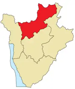 Location of Butanyerera in Burundi | |
| Coordinates: 3°S 30°E / 3°S 30°E | |
| Country | |
| Capital | Ngozi |
| Government | |
| • Governor | Victor Segasago (CNDD-FDD) |
| Area | |
• Total | 4,480 km2 (1,730 sq mi) |
| Population (2024 census)[1] | |
• Total | 2,530,206 |
| • Density | 560/km2 (1,500/sq mi) |
| Time zone | UTC+2 (CAT) |
Butanyerera is the second most populous of Burundi's five provinces. It covers an area of 4,480 square kilometres (1,730 sq mi) and recorded a population of 2,530,206 in the 2024 Burundian census.[1] The capital and the largest town in the province is Ngozi, which reported a population of 39,884 in the 2008 Burundian census.[2] Other significant towns in Butanyerera include Kayanza and Kirundo, which reported populations of 21,767 and 10,024 respectively in the 2008 Burundian census.[2]
Geography
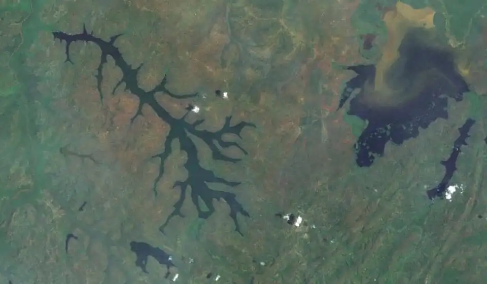
Located in northern Burundi, Butanyerera borders the Burundian provinces of Bujumbura, Gitega and Buhumuza to the west, south and east respectively, and Rwanda's Southern and Eastern provinces to the northwest and northeast respectively. Terrain in the province ranges in elevation from 1,325 metres (4,347 ft) at Lake Rweru in the Bugesera Depression to the northeast,[3] to over 2,600 metres (8,500 ft) on the Congo-Nile ridge in Kibira National Park in the west.[4] The central part of Butanyerera lies on the Buyenzi plateau,[5] one of Burundi's major coffee-producing regions.[6]
Butanyerera contains the eastern side of Kibira National Park, which protects the Albertine Rift montane forests of the Mugamba natural region.[7] The Protected Aquatic Landscape of the North Ramsar site is located in the northeastern part of Butanyerera near the Rwandan border, and protects Lakes Cohoha, Gacamirindi, Kanzigiri, Mwungere, Nagitamo, Narungazi, Rweru, and Rwihinda, as well as Murehe Forest.[8][9] Kibira National Park and Lake Rwihinda are on Burundi's list of Tentative World Heritage Sites,[10] as are the royal tombs of Nkiko-Mugamba, located in the zones of Kabarore and Muruta in the commune of Kayanza.[11]
History
On 16 March 2023, President of Burundi Évariste Ndayishimiye signed into law a reorganization of Burundi's administrative divisions,[12] which included the reduction of Burundi's provinces from eighteen to five.[13] Butanyerera was created from the merger of the former provinces of Kayanza, Kirundo and Ngozi, as well as parts of the former commune of Bukeye in the province of Muramvya, namely the zone of Busangana and the collines of Busekera, Kigereka and Shumba in the zone of Bukeye.[13] The new provinces took effect with Burundi's 2025 parliamentary and local elections. Butanyerera's first governor Victor Segasago was sworn in on 4 July 2025.[14][15]
Butanyerera was previously the name of a chiefdom created in 1959 from the southern part of the chiefdom of Buyenzi in the territory of Ngozi, which Louis Rwagasore briefly administered.[16]
Communes
Butanyerera is divided into eight communes: Busoni, Kayanza, Kiremba, Kirundo, Matongo, Muhanga, Ngozi, and Tangara.[12]
References
- ^ a b c Brinkhoff, Thomas (7 June 2025). "Burundi: Administrative Division". City Population. Retrieved 3 August 2025.
- ^ a b Brinkhoff, Thomas (8 June 2025). "Burundi". City Population. Retrieved 3 August 2025.
- ^ "Appendix C". Rusumo Falls hydroelectric project – dam and powerplant component: environmental and social impact assessment (ESIA) (PDF) (Report). Artelia. February 2013. p. 7. Retrieved 3 August 2025 – via Nile Basin Initiative.
- ^ "Parc National de la Kibira (PNK)". Biodiversité du Burundi (in French). Convention on Biological Diversity. Retrieved 3 August 2025.
- ^ Duchaufour, Hervé (2012). "Aspects socio-économiques et démographiques du développement durable de la société rurale du Burundi" [Socio-economic and demographic aspects of sustainable development of Burundiʼs rural society]. Lutte antiérosive (in French). IRD Éditions. doi:10.4000/books.irdeditions.12419. Retrieved 3 August 2025 – via OpenEdition Books.
- ^ Coste, René (1992). Coffee: The Plant and the Product. London: MacMillan. p. 261. ISBN 9780333572962.
- ^ "Le parc national de la Kibira". World Heritage Convention (in French). UNESCO World Heritage Centre. 9 May 2007. Retrieved 3 August 2025.
- ^ "Paysage Aquatique Protégé du Nord". Ramsar Sites Information Service. 14 March 2013. Retrieved 3 August 2025.
- ^ "Paysage Aquatique Protégé du Nord". Biodiversité du Burundi (in French). Convention on Biological Diversity. Retrieved 3 August 2025.
- ^ "Burundi". World Heritage Convention. UNESCO World Heritage Centre. Retrieved 3 August 2025.
- ^ "Les paysages naturels sacrés de Muramvya, de Mpotsa et de Nkiko-Mugamba". World Heritage Convention (in French). UNESCO World Heritage Centre. 9 May 2007. Retrieved 3 August 2025.
- ^ a b Ndayishimiye, Évariste (16 March 2023). "Loi Organique N° 1/05 du 16 Mars 2023 portant détermination et délimitation des provinces, des communes, des zones, des collines et/ou quartiers de la République du Burundi" (in French). CENI Burundi. Retrieved 27 July 2025.
- ^ a b "Projet de loi organique portant délimitation des provinces, des communes, des zones, des collines/quartiers de la République du Burundi" (PDF). Senate of Burundi. Retrieved 27 July 2025.
- ^ "Senate approves Five New Provincial Governors After Major Administrative Reform". Breaking Burundi. 4 July 2025. Retrieved 3 July 2025.
- ^ Manirakiza, Patrick (6 July 2025). "Burundi's new Governors sworn in following major provincial reforms". Burundi Times. Retrieved 27 July 2025.
- ^ Deslaurier, Christine, ed. (2012). Paroles et écrits de Louis Rwagasore, leader de l'indépendance du Burundi (in French). Translated by Nizigiyimana, Domitien. Éditions Karthala. pp. 111, 227. ISBN 978-2-8111-0701-7. Retrieved 3 August 2025.