Church Street, Dublin
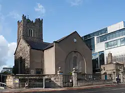 St Michan's church as viewed from Church Street with an adjacent modern office block | |
| Native name | Sráid an Teampaill (Irish) |
|---|---|
| Namesake | St. Michan's Church |
| Postal code | D07 |
| south end | Father Mathew Bridge |
| Major junctions | Inns Quay North Brunswick Street North King Street |
| north end | Constitution Hill |
Church Street (Irish: Sráid an Teampaill)[1] is a street in Dublin, Ireland which dates back to at least Early Scandinavian Dublin.
History
In the early history of Dublin, Church Street was the main unplanned thoroughfare of Oxmanstown, an area that developed outside of the walled city, on the northern side of the River Liffey near the old crossing point of the ford of the hurdles from which Dublin gets its name.[2]
It is believed to have taken its name from the chapel on the street from 1095 on which St. Michan's Church was built.[2][3][4][5] The area likely expanded significantly after the Anglo-Norman invasion of Ireland and the expulsion or voluntary removal of the Norse–Gaels from the old city.
It later appears clearly on John Speed's Map of Dublin (1610).[6]
By the thirteenth century, there were numerous ironworks, markets and slaughterhouses.[2]
By the eighteenth century, the area was one of Dublin's most densely populated and poorest, and this reputation and deprivation continued into the 1800s.[2] The printer of the Gentleman's and Citizen's Almanac, John Watson Stewart (1762-1822), lived at 1 Church Street.[5]
In 1878, Dublin's worst industrial accident occurred on Church Street, when a boiler exploded and killed 14 people. The accident happened at Hammond Lane, the site of Messrs Strong, a large foundry and ironworks in the nineteenth century. In the afternoon of 27 April 1878, a large explosion was heard, and panic spread in the area. The steam boiler at Strong's foundry had exploded, partially demolishing the front wall of the foundry. As the explosion took place around 1:30pm, many of the employees were on their lunch break. Duffy's public house, across from the foundry was destroyed in the explosion, and killing Patrick Duffy, the publican, and two of his children. Two tenements were also destroyed in the blast. An engineer's report cited lack of maintenance of the boiler, and that corrosion had weakened it.[2]
At the south end of the street, a site at Hammond Lane that has been earmarked for development as part of the larger Four Courts complex. It has remained a brown field site for a long period of time.[2]
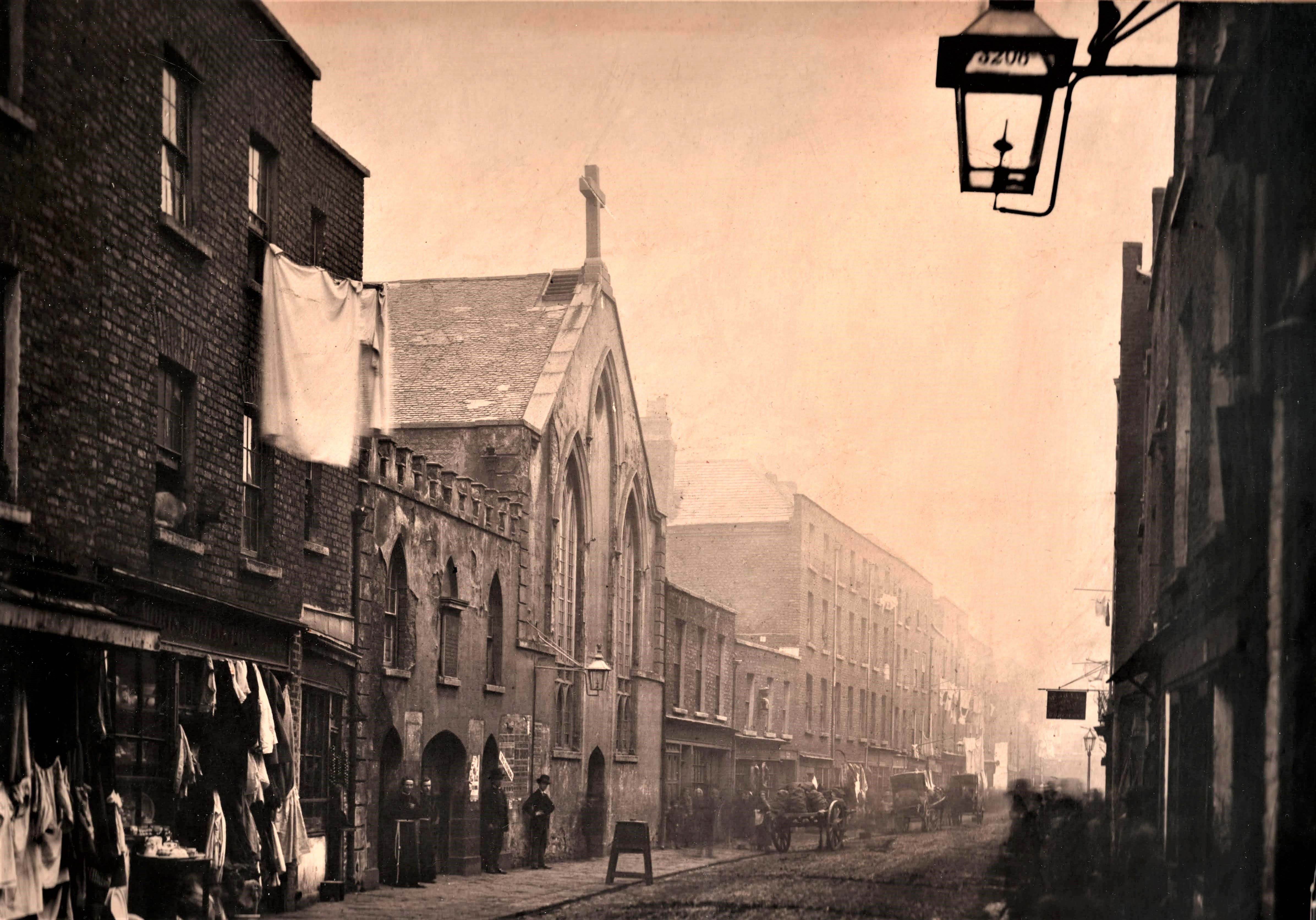
The Church Street disaster (1913)
_-_panoramio_(1).jpg)
On Tuesday 2 September 1913, two tenement buildings, numbers 66 and 67, collapsed at 8:45pm.[7][8] 25 people from 5 families lived in number 66 alone.[9] It is believed that the chimney collapsed, falling through the building while pushing the front elevation onto the street. Seven people died in the collapse, including four children. The buildings were directly across from the church of the Capuchin Order, St Mary of the Angels Church. The safety of the buildings had been questioned in July 1911, and minor repairs were made. The disaster attracted a lot of national and international press, as it happened during the 1913 Lockout. One of the victims, Hugh Sammon, had been locked out of work the day before the collapse.[2]
An inquiry into the collapse detailed that 16 members of the Dublin Corporation owned 89 tenements or "second-class houses" between them.[2]
The wider area was redeveloped into local authority housing as the Church Street Housing Scheme, with Alderman Thomas Kelly largely credited with this development, working with C.J. McCarthy, the Dublin City Architect. This public housing scheme was one of a number that marked a turn in political attitudes to housing in Dublin in the early 20th century. A memorial now marks the spot of the collapse.[2][10]
Architecture

The Capuchin Order has had a premises on Church Street since 1689,[5] Saint Mary of the Angels, Capuchin Church was built as a replacement in 1881 and was designed by J.J. McCarthy, and features sculptures from Leo Broe and work from James Pearse (father of Patrick Pearse).[11][5]
Since the 1960s, the Capuchin Day Centre has been offering free meals and was founded by Kevin Crowley.
In 1891, the Father Matthew Hall was opened as a temperance social club. The Hall hosted meetings of the Gaelic League, and was a field hospital and kitchen during the Easter Rising in 1916.[2] It also could be one of the oldest cinematic venues in Dublin, with advertisements dating from October 1909.[5]
Some of the houses on Church Street date back to the 1740s.[12] The mural, 'Horse Boy', by Subset is at the intersection of Church Street and Stirrup Lane and is inspired by the area's proximity to the Smithfield Horse Fair.[2]
External links
References
- ^ "Sráid an Teampaill/Church Street". logainm.ie. Retrieved 29 July 2025.
- ^ a b c d e f g h i j k Fallon, Donal (2022). "Church Street". Three castles burning: a history of Dublin in twelve streets. Clonskeagh, Dublin: New Island Books. pp. 180–201. ISBN 9781848408722.
- ^ "Saint Michan's Church, Church Street, Bow Street, Dublin 7, DUBLIN". Buildings of Ireland. Retrieved 29 July 2025.
- ^ Clerkin, Paul (2001). Dublin Street Names. Dublin: Gill & Macmillan. p. 35. ISBN 9780717132041.
- ^ a b c d e Neary, Bernard (2016). Dublin 7: Ashtown, Broadstone, Cabra, Church Street, Ellis & Arran Quays, Oxmantown, Phibsborough, Royal Canal, Smithfield, Stoneybatter. Dublin, Ireland: The Lilliput Press. pp. 267–270. ISBN 978-1-84351-681-1.
- ^ M'Cready, C.T. (1987). Dublin Street Names: Dated and Explained. Dublin: Carraig Books. p. 22. ISBN 1850680000.
- ^ "The Church Street disaster, September 1913 – History Ireland". historyireland.com. Retrieved 29 July 2025.
- ^ Curry, James (2 September 2013). "Column: 'A tragedy of the very poor' – Remembering the 1913 Church Street disaster". TheJournal.ie. Retrieved 29 July 2025.
- ^ "Tragedy in Dublin as tenements collapse | Century Ireland". Century Ireland. Retrieved 29 July 2025.
- ^ "Dictionary of Irish Architects". www.dia.ie. Retrieved 30 July 2025.
- ^ "Catholic Church of Saint Mary of the Angels, 137-142 Church Street, Bow Street, Dublin 7, DUBLIN". Buildings of Ireland. Retrieved 29 July 2025.
- ^ "143 Church Street, Dublin 7, DUBLIN". Buildings of Ireland. Retrieved 29 July 2025.