Forset
Forset | |
|---|---|
Village | |
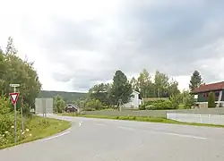 View of the village | |
 Forset  Forset | |
| Coordinates: 61°12′08″N 10°08′38″E / 61.20212°N 10.14384°E | |
| Country | Norway |
| Region | Eastern Norway |
| County | Innlandet |
| District | Gudbrandsdal |
| Municipality | Gausdal Municipality |
| Area | |
• Total | 0.71 km2 (0.27 sq mi) |
| Elevation | 339 m (1,112 ft) |
| Population (2024)[1] | |
• Total | 608 |
| • Density | 856/km2 (2,220/sq mi) |
| Time zone | UTC+01:00 (CET) |
| • Summer (DST) | UTC+02:00 (CEST) |
| Post Code | 2653 Vestre Gausdal |
Forset[3] is a village in Gausdal Municipality in Innlandet county, Norway. The village is located along the river Jøra, about 6 kilometres (3.7 mi) west of the villages of Follebu and Segalstad bru. Vestre Gausdal Church is located in the village.[4]
The 0.71-square-kilometre (180-acre) village has a population (2024) of 608 and a population density of 856 inhabitants per square kilometre (2,220/sq mi).[1]
History
Forset was the administrative centre of the old Vestre Gausdal Municipality, which existed until 1962 when it became a part of Gausdal Municipality.[4]
References
- ^ a b c Statistisk sentralbyrå (1 October 2024). "Urban settlements. Population and area, by municipality".
- ^ "Forset, Gausdal". yr.no. Retrieved 22 July 2022.
- ^ "Informasjon om stadnamn". Norgeskart (in Norwegian). Kartverket. Retrieved 29 July 2025.
- ^ a b Thorsnæs, Lars, ed. (29 March 2022). "Mæhlum". Store norske leksikon (in Norwegian). Kunnskapsforlaget. Retrieved 22 July 2022.