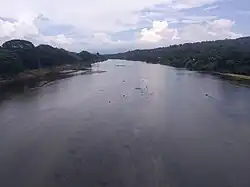
Haungtharaw River

The Haungtharaw River, also known as the Haungthayaw River,[1] is a river of Kayin State, in southeastern Burma (Myanmar). It has its source in the Dawna Range and flows into the Gyaing River.[2] It originates in the Dawna Range, a granite and limestone mountain chain famed for its tropical moist forests and biodiversity. After descending from these forested highlands, the river joins the Hlaingbwe River to form the broader Gyaing River; a wide, shallow waterway traversable by smaller boats year-round and contributing vital water flow into the Thanlwin (Salween) River. The narrow valley carved by the Haungtharaw is a defining feature of the region’s topography, forming one of the distinct riverine corridors that typify the landscape of eastern Kayin State. This valley supports lush vegetation and encloses layered ecosystems where upland forests meet riparian flora.[3]
Notes
- ^ "Map of Kayin State" Archived 2011-06-15 at the Wayback Machine Myanmar's net
- ^ "Burma 1:250,000 topographic map, Series U542, Moulmein, NE 47-14" U.S. Army Map Service, December 1959
- ^ https://myanmar-law-library.org/IMG/pdf/amherst_district_volume_-a.pdf
See also
16°36′12″N 98°00′25″E / 16.60333°N 98.00694°E