Hoher Ziegspitz
| Hoher Ziegspitz | |
|---|---|
 | |
| Highest point | |
| Elevation | 1,864 m (6,115 ft) |
| Geography | |
| Location | Bavaria, Germany |
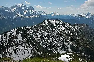
Hoher Ziegspitz is a 1864 m high peak of the Ammergau Alps mountain range in Bavaria, Germany.It forms the westernmost peak of the Kramer range, which is situated northwest of the town of Garmisch-Partenkirchen. The mountain is a popular destination for hikers due to its scenic views, relatively moderate difficulty, and proximity to several well-known alpine routes.
Etymology [1]
Despite its name, "Ziegspitz" does not derive from the German word for "goat" (Ziege), as often assumed. Instead, it likely comes from the regional dialect term “Zügen,” which refers to avalanche paths or corridors—similar to the etymology of nearby Zugspitze.
Geography[2]
Hoher Ziegspitz is part of the Ammergau Alps, a subrange of the Northern Limestone Alps. It lies approximately 7 km west of Garmisch-Partenkirchen and just south of the village of Griesen, which serves as an alternative trailhead. The mountain forms a distinct, pyramid-shaped peak when viewed from the Loisach Valley and is surrounded by lesser summits such as the Vorderer Ziegspitz and Rauhenstein.
- Coordinates: 47°30′08″ N, 11°00′14″ E
- Prominence: Approximately 300 m
- Parent range: Ammergau Alps
Geology
Hoher Ziegspitz is predominantly composed of Hauptdolomit (Main Dolomite), dating back to the Upper Triassic period. The rugged terrain features steep slopes, scree fields, and distinct ridgelines. This geology contributes to its moderately challenging hiking routes and occasional exposed segments along certain paths.
Access and Hiking
Hoher Ziegspitz is a well-known destination for day hikes, particularly during the summer months (May to October). The most popular approach begins in Garmisch-Partenkirchen, though other routes start from Griesen or Ehrwald in Austria
Main Hiking Route (via Stepbergalm) [3]
- Starting Point: Parkplatz Maximilianshöhe or St. Martin area in Garmisch
- Elevation Gain: ~1,100–1,170 m
- Round Trip Distance: ~15–16 km
- Estimated Time: 5 to 6.5 hours
- Trail Conditions: Moderate difficulty (T2), with some steep and narrow segments
Route Description:
- Hike through forested trails to Stepbergalm (~1,583 m), a seasonal alpine hut open May to October.
- Ascend to the Stepbergsattel, a ridge saddle with panoramic views.
- Continue along the southwest ridge to the summit of Hoher Ziegspitz.
- Optional descent via the Gelbes Gwänd, a more exposed trail with wire-rope sections.
Alternative Routes [4]
- East–West Traverse: A longer alpine route starting in Griesen, crossing over the summit and descending to Garmisch (~20 km total).
- Loop Variations: Combining the route with nearby peaks or alpine meadows like Rotmoosalm or Vorderer Ziegspitz.[5]
Summit and Views [6]
From the summit, hikers are rewarded with expansive panoramic views of:
- Zugspitze and the Wetterstein range to the south
- Karwendel Mountains to the east
- The Ammergau Alps extending westward
- The Lechtal Alps in the distance
Due to its location and relative solitude compared to nearby Kramer or Wank, the Ziegspitz summit is regarded as a peaceful spot for photography and nature observation.
Flora and Fauna
The mountain is home to alpine meadows, dwarf pine, and typical limestone flora. Wildlife sightings may include:
- Chamois
- Alpine marmots
- Golden eagles
- Alpine newts in moist habitats
Safety and Recommendations
- Best Season: Late spring to early autumn (May–October)
- Recommended Gear: Sturdy hiking boots, map or GPS, weather-appropriate clothing
- Dangers: Slippery trails after rain, exposed sections (especially on Gelbes Gwänd)
- Mountain Huts: Stepbergalm (open seasonally; closed Mondays)
Public Transportation: Garmisch-Partenkirchen is well connected via train. Local buses run to trailheads, and routes can be planned using the Deutsche Bahn or RVO systems.
References
- ^ "Hoher Ziegspitz", Wikipedia (in German), 2025-06-03, retrieved 2025-08-15
- ^ "Hoher Ziegspitz - Peakbagger.com". www.peakbagger.com. Retrieved 2025-08-15.
- ^ "Hoher Ziegspitz - A touch of adventure on the Grießberg". www.outdooractive.com. Retrieved 2025-08-15.
- ^ "Hoher Ziegspitz". www.outdooractive.com. Retrieved 2025-08-15.
- ^ "Hoher Ziegspitz über die Stepbergalm". AllTrails.com. Retrieved 2025-08-15.
- ^ "Hoher Ziegspitz Summit - Routes and Map". komoot. Retrieved 2025-08-15.