King's Cross Central
King's Cross Central is a mixed-use development in the north-east of central London. The site is owned and controlled by the King's Cross Central Limited Partnership. It consists of approximately 67 acres (27 ha) of former railway lands to the north of King's Cross and St Pancras mainline railway stations.[1] The site is largely determined by three boundaries: the existing East Coast Main Line railway leading out of King's Cross; York Way, a road marking the division between Camden and Islington boroughs; and the new railway line, High Speed 1 (HS1), formerly known as the Channel Tunnel Rail Link, which curves around the site to the north and west.
The master planners for the development were Allies and Morrison, Demetri Porphyrios, and Townshend Landscape Architects. The overall developer is Argent LLP.[2] In 2016, the government announced it had sold their investment in Kings Cross Central for £371 million.[3] The final building of the masterplan was approved in the summer of 2023.[4]
History
The area of what is today Kings Cross was farmland, intersected by York Way heading north leading to a bridge which crossed the River Fleet at Battlebridge. This name led to a tradition that this was the site of a major battle between the Romans and the Iceni tribe led by Boudica (also known as Boudicea), support by writings from the ancient Roman historian Publius Cornelius Tacitus.[5] It was not until the development of New Road in 1765 (later to become Euston Road), that the development of Kings Cross began.
1820's: Regents Canal

Initially developed as terraced housing, with the opening of the Regents Canal in 1820 the area became industrialised. In 1822 the Imperial Gas Light and Coke Company developed a gas works south of the canal[6], which drew a number of other highly-polluting industries into the area.
1830's: Kings Cross
A a 60-foot (18 m) high monument topped by an 11-foot (3.4 m) statue of King George IV was built at the junction of Gray's Inn Road, Pentonville Road and New Road, which later became Euston Road. Designed by architect Stephen Geary,[7] the statue was constructed of bricks and mortar, and finished in a manner that gave it the appearance of stone "at least to the eyes of common spectators".[8] Described by George Walter Thornbury as "a ridiculous octagonal structure crowned by an absurd statue",[5] the unpopular building was demolished in 1845, though the area kept the name of Kings Cross.[5]
A structure in the form of a lighthouse was built on top of a building almost on the site about 30 years later. Known locally as the "Lighthouse Building", the popular theory that the structure was an advertisement for Netten's Oyster Bar on the ground floor seems not to be true.[9] It is a grade II listed building.[10]
Railway stations
1849-1852: Great Northern Railway's King's Cross
In 1849, the Great Northern Railway (GNR) began development of their East Coast Main Line and station in the area. Purchasing land north of the canal for their goods yard and engine depot, they purchased land south of the canal for their King's Cross railway station. However, with the oncoming Great Exhibition, they decided to open a small temporary two-platform station within the goods area named Maiden Lane railway station. In 1852 the line was completed over the canal and Kings Cross station, designed by architect Lewis Cubitt, opened.[11]
1850's-1860's: Midland Railway's St Pancras
Before the 1860s, the Midland Railway had a network of routes in the Midlands, south and west Yorkshire and Lancashire and until 1857 the company had no line into London, and used the lines of the London and North Western Railway. After 1857, the company's Leicester and Hitchin Railway gave access to London via the GNR.[12] However, traffic for the second International Exhibition in 1862 suffered great delays over both lines, so the decision was taken to develop its own London terminus from Bedford.[13] Surveying for a 49.75-mile (80 km) long line began in October 1862.
Designed by William Henry Barlow,[14] the approaching line to the station crossed the Regent's Canal at height, as a result the line at St Pancras railway station had to be 12 to 17 ft (3.7 to 5.2 m) above ground level. Initially planned to be filled with spoil from the tunnels north of the railway lands, instead the void was used for dry freight, including beer from the Brewers of Burton. Beer freight was processed in the centre of the station, between platforms 4 and 5. A central third track ended in a wagon hoist lowering wagons 20 feet (6.1 m) below rail level; beer storage ended in 1967.[15]
The contract for the construction of the station substructure and connecting lines was given to Waring Brothers, with Barlow's assistant Campion as supervisor.[16] To avoid the foundations of the roof interfering with the space beneath, and to simplify the design and minimise cost, they decided to construct a single span roof, with cross ties for the arch at the station level. Constructed by the Butterley Company, the span width, from wall to wall was 245 ft 6 in (74.83 m), with one of 24 ribs every 29 ft 4 in (8.94 m). The resultant single-span roof was 679 feet (207 m) long, 236 feet (72 m) wide, and 98 feet (30 m) high at the apex above the tracks, and was the largest such structure in the world at the time of its completion.[14]
Construction of a hotel fronting the station, the Midland Grand Hotel, began in 1868, and opened in 1873; the design of the hotel and station buildings was by George Gilbert Scott, selected by competition in 1865. The building is primarily brick, but polychromatic, in a style derived from Italian gothic, with numerous other architectural influences.[17]
The railway lands
Both railway companies had land north of the canal, which due to their previous industrial and now commercial use became known as the "railway lands". The company also added the Eastern coal drops (1851), and the later Western coal drops (1860), allowing coal shipments from the Northeast and Midlands to be distributed around London by the canal network, and later by road. In 1888, a canopy was added to provide a sheltered space for potatoes, east of this was a potato market.[18] The gas works also continued to expand, covering 11 acres (4.5 ha) by the early 1900s.
Post 1945: Decline
After World War II the area declined from being a poor but busy industrial and distribution services district to a partially abandoned post-industrial district. By the 1980s it was notorious for prostitution and drug abuse. This reputation impeded attempts to revive the area utilising the large amount of land available following the decline of the railway goods yard to the north of the station and the many other vacant premises in the area.[19]
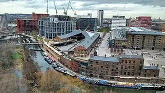
Regeneration
.jpg)
In 1989, the London Regeneration Consortium (LRC) submitted proposals to develop the railway lands. In the 1990s the government established the King's Cross Partnership to fund regeneration projects.[20] The London Borough of Camden was "minded to grant" planning proposals for these proposals in 1994. The proposals were subsequently withdrawn.
The former Midland Railway goods depot to the west of St Pancras was sold to the British Library. Since 1997 the main collection has been housed in this single building, designed specially for the purpose by the architect Colin St John Wilson.[21] It was the largest public building constructed in the United Kingdom in the 20th century.[22]
A small area of the project, known as the "Triangle Site", fell within the boundaries of Islington. Camden Council granted outline planning permission for the main part of the site in early 2006. This was approved by the government and the Mayor of London, although separate planning permission for the Triangle Site was required from Islington Council. Islington Council initially refused planning permission. There was a public Inquiry in April 2008, and local residents from the King's Cross Railway Lands Group and the Cally Rail Group gave evidence objecting to the proposed development. In July, the inquiry concluded it was in favour of the development.[23]
The commencement of work on High Speed 1 in 2000 provided a major impetus for wider redevelopment. The London terminus of the Eurostar international rail service moved to St Pancras station in November 2007 with the station's redevelopment leading to the demolition of several buildings, including the Gasworks.[24] Following the reopening of the station, redevelopment of the land between the two major stations and the old Kings Cross railway lands to the rear commenced, which included a major renovation and extension of Kings Cross Station itself to bring it up to the same standard as newly restored St Pancras. Meanwhile, outline planning permission was granted for the whole site which included new housing and office developments, as well as a planned amphitheatre made from one of the old gasometers.
The majority of the land at King's Cross Central was used for HS1 construction purposes from July 2001 until autumn 2007. Following the opening of HS1 on 14 November 2007, and with outline planning permission, GLA (Greater London Authority) and GOL approval, the developer Argent Group PLC started the development. Many buildings have been completed and Central Saint Martins of the University of the Arts London was the first occupant of a redeveloped listed buildings.
Detailed planning applications for each part of the site were made on a rolling programme basis. Following completion of the London 2012 Summer Olympics site, King's Cross Central was one of the largest construction projects in Greater London in the first quarter of the 21st century.
The majority of the site falls within two conservation areas. There are several buildings and structures of heritage value, some of which are listed.[25]
Many organisations are affected by the decisions that will be taken by the developers. A partial list includes Camley Street Natural Park, The Cross nightclub, and St Pancras Cruising Club.
Proposed development
King's Cross Central has been identified in national, regional, and local policies as a high density development. It is a brownfield site (i.e. had past industrial use) with excellent public transport links. Buildings proposed ranged from 1 storey to 19 storeys. Protected views of St Paul's from Parliament Hill and Kenwood House will not be affected.
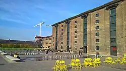
At least a third of the site (25 acres/10 hectares) was dedicated to new public routes and open spaces. Argent proposed to create 20 new major routes and 10 new privately owned public spaces. Five of these are major new squares - Granary Square, Station Square, Pancras Square, Cubitt Square, and North Square - which together total 8 acres (3.2 ha).
In addition, the proposals included 6.5 acres (2.6 ha) of new public realm along the Regent's Canal (the Gas Holders Zone and Coal Drops Yard[26] and within a new "Cubitt Park". Argent invested in improvements to the canal corridor, notably lighting and access from Granary Square. About a mile along the towpath to the west is Camden Market, and beyond that Regent's Park and London Zoo; to the east is the Islington Tunnel and then Upper Street, a busy retail and entertainment area. Camley Street Natural Park, Old St. Pancras Church, and Somers Town are now connected to Kings Cross Central by a footbridge, one of three new crossings over the Regent's Canal.
Awards
London Planning Awards: The Granary Complex won the Mayor's Award for Planning Excellence in 2012.[27]
Royal Academy of Engineering: The engineering and design consultancy Arup won the Major Project Award for their contribution to the redevelopment of King’s Cross Central, in 2014.[28]
New London Architecture Awards: Winner of the masterplan and areas strategies category in 2014.[29]
AJ Architecture Awards: R7 by Morris+Company, in the northern quarter, won best workplace (10,000m² and over) in 2019.[30]
Royal Institute of British Architects: RIBA London Award 2024, RIBA National Award 2024 and shortlisted for the RIBA Stirling Prize 2024.[2]
Notable residents and businesses
The artists Sir Antony Gormley and Vicken Parsons, Lady Gormley live in a converted gasholder in the area.[31]
It was reported in January 2013 that Google would be acquiring a million square feet within King's Cross Central.[32]
It was also reported in September 2014 that Havas, the Global communications group, will consolidate its existing twenty-four London offices into one new building at Three Pancras Square at Kings Cross Central.[33]
Universal Music Group moved from Kensington to Kings Cross Central in 2018, whilst AstraZeneca moved their headquarters to Kings Cross Central in 2022.[34]
A separate development, Kings Place, lies across the road on the east side of York Way. Network Rail and The Guardian newspaper are based there. It also includes two art galleries and concert halls.[35]
Transport links
King's Cross/St Pancras is already served by six London Underground lines (the Northern, Piccadilly, Victoria, Circle, Metropolitan and Hammersmith & City), by Thameslink, Midland Main Line, East Coast Main Line, and Eurostar. These services, coupled with the ability to access each of the four main airports in the South East (Heathrow, Gatwick, Stansted and Luton airports), make King's Cross the most accessible transport interchange in London. There have been HS1-related works to the London Underground system, in particular works to construct a new Northern Ticket Hall, which opened in 2009.[36] A new Western Ticket Hall was opened to the public on 28 May 2006. Network Rail has redeveloped King's Cross station, relocating the ticket hall and other functions from the former temporary structure which fronted Euston Road.
Controversies
Social housing commitments and controversy
Argent have partnered with One Housing Group to provide rented and joint ownership housing units. A 2012 investigation by The Independent and Corporate Watch into the initial allocations found that "people with a history of mental health problems are being excluded from the social housing built there while the developers and local council have also set quotas for the number of homeless and unemployed people" at King's Cross Central's 500 social housing units.[37]
Argent's planning permission agreement with Camden Borough council included a commitment to provide 750 affordable units in the 1,946 constructed. This is intended to include lower and middle range rents and joint ownership properties. Argent have however asked to reduce the commitment by 21 social homes and 96 mid-level rented homes in order to sell 100 extra luxury flats.[38]
Facial recognition system controversy
In 2019 Madhumita Murgia reported in the Financial Times that Argent was using facial recognition software in the King's Cross Central area of London. The development around London's King's Cross mainline station includes shops, offices, Google's UK HQ and part of St Martin's College. Murgia told the BBC Argent had refused to give any detailed information about how the system was used and what kind of watch list was involved. The ICO said: "Scanning people's faces as they lawfully go about their daily lives, in order to identify them, is a potential threat to privacy that should concern us all." Elizabeth Denham, the UK Information Commissioner launched an investigation into the use of the King's Cross facial recognition system. "This is inherently a surveillance tool that bends towards authoritarianism," said Silkie Carlo of Big Brother Watch.[39][40][41]
See also
- York Central - similar railway lands brownfield regeneration site, beside York railway station.
References
- ^ "Government starts sale of its investment in King's Cross Central development". GOV.UK. Retrieved 12 August 2025.
- ^ a b "King's Cross Masterplan". www.architecture.com. Retrieved 12 August 2025.
- ^ "Government sells King's Cross development stake to reduce the deficit". GOV.UK. Retrieved 13 August 2025.
- ^ Oliver, Jack (19 July 2023). "Final King's Cross masterplan building approved". Completely Retail News. Retrieved 13 August 2025.
- ^ a b c Walter Thornbury (1878). "Highbury, Upper Holloway and King's Cross". Old and New London: Volume 2. British History Online. pp. 273–279. Retrieved 11 November 2010.
- ^ "Imperial Gas Light and Coke Company". National Archives. Retrieved 13 August 2025.
- ^ Godfrey, Walter H.; Marcham, W. McB, eds. (1952). "Euston Road". Survey of London: volume 24: The parish of St Pancras part 4: King’s Cross Neighbourhood. Institute of Historical Research. Retrieved 24 May 2012.
- ^ Urban, Sylvanus (1836). "The Architectural Magazine, conducted by J.C. Loudon F.L.S. &c. Vol. III. Nos. XXIII. to XXX". The Gentleman's Magazine. 6 (new series): 627–8. quoting The Architectural Magazine
- ^ Greater London Industrial Archaeology Society newsletter, February 2000 (accessed 15 April 2008
- ^ Listed building details, Camden Council, accessed 15 April 2008 Archived 14 May 2012 at the Wayback Machine
- ^ "The history of London King's Cross station". Network Rail. Retrieved 12 August 2025.
- ^ Barlow 1870, p. 78.
- ^ Williams, Frederick S. (1888), "VII. 'Difficulties and Delays'", The Midland railway, its rise and progress, a narrative of modern enterprise (5 ed.), Richard Bentley & Son., pp. 128–9, OL 7043506M
- ^ a b St. Pancras Station, Our Transport Heritage
- ^ Lambert, Anthony J. (2010). Lambert's Railway Miscellany. London: Ebury. ISBN 978-0-09-193771-3.
- ^ Barlow 1870, p. 82.
- ^ "St. Pancras Station", transportheritage.com, retrieved 25 August 2012
- ^ "Midland Goods Shed & East Handyside Canopy Kings Cross". King's Cross. Archived from the original on 30 November 2020. Retrieved 12 August 2025.
- ^ "To the lighthouse". Inside Housing. Retrieved 12 August 2025.
- ^ [1] Archived 4 February 2012 at the Wayback Machine
- ^ "History of the British Library". British Library. Archived from the original on 13 February 2010. Retrieved 7 February 2010.
- ^ "British Library becomes Grade I listed building". BBC News. 31 July 2015. Retrieved 13 August 2025.
- ^ "The Money Blogger – I blog about money and stuff". Archived from the original on 28 August 2008.
- ^ Built in the 1860s and rebuilt in the 1880s, the gasholders (of unique linked triplet design) were still in use until 1999. Several gasholders (the site was originally a gasworks) that had dominated the area behind station for over a century have been taken down during the building works and placed in storage, and it is intended that they should be re-erected, but converted,possibly for housing.
- ^ Adelfio, Marco; Hamiduddin, Iqbal; Miedema, Elke (15 March 2021). "London's King's Cross redevelopment: a compact, resource efficient and 'liveable' global city model for an era of climate emergency?". Urban Research & Practice. 14 (2): 180–200. doi:10.1080/17535069.2019.1710860. ISSN 1753-5069.
- ^ Wills, Kate (18 October 2018). "Coal Drops Yard is London's new eating, shopping and playing paradise". Evening Standard. London. Retrieved 26 October 2018.
- ^ "Granary Building scoops Mayor's top prize for planning excellence | London City Hall". www.london.gov.uk. Retrieved 13 August 2025.
- ^ "Arup team wins award for delivering the new King's Cross". www.imeche.org. Retrieved 13 August 2025.
- ^ "Kings Cross takes top prize in New London Architecture awards - Landscape Institute". 21 July 2014. Retrieved 13 August 2025.
- ^ Hurst, Will (19 November 2019). "AJ Architecture Awards 2019 winner: Workplace (10,000sqm and over)". The Architects’ Journal. Retrieved 13 August 2025.
- ^ Healy, Rachael (31 August 2024). "Antony Gormley joins fight against 'destruction' of historic King's Cross site". The Guardian. Retrieved 1 July 2025.
- ^ Matthew Bell (17 January 2013). "Google confirms King's Cross HQ development". Construction News. Retrieved 18 January 2013.
- ^ "GLOBAL MEDIA GIANT, HAVAS, COMES TO KING'S CROSS". 3 September 2014. Archived from the original on 30 May 2015. Retrieved 23 May 2015.
- ^ "King's Cross, a miracle in London". The Economist. ISSN 0013-0613. Retrieved 13 August 2025.
- ^ Glancey, Jonathan (27 August 2008). "A look around Kings Place, the Guardian's new home". the Guardian. ISSN 0261-3077. Retrieved 13 August 2025.
- ^ "Delayed Northern ticket hall opens at King's Cross". railnews.co.uk. Retrieved 20 August 2011.
- ^ King's Cross Central: 'a crude exercise in social engineering' Archived 17 March 2015 at the Wayback Machine, Corporate Watch 24 September 2012
- ^ Axed: King’s Cross social homes as developer bids to build more luxury flats Camden New Journal, 9 April 2015
- ^ Murgia, Madhumita (12 August 2019). "London's King's Cross uses facial recognition in security cameras". Financial Times. Archived from the original on 11 December 2022. Retrieved 17 August 2019.
- ^ Cellan-Jones, Rory (16 August 2019). "Tech Tent: Is your face on a watch list?". BBC News. Retrieved 17 August 2019.
- ^ "King's Cross facial recognition investigated". BBC News. 15 August 2019. Retrieved 17 August 2019.
Sources
- Barlow, W. H. (1870). "Description of the St. Pancras Station and Roof, Midland Railway. (Includes Plates)". Minutes of the Proceedings. 30 (1870): 78–93. doi:10.1680/imotp.1870.23014.
Further reading
- Bertolini, Luca; Spit, Tejo (1998). Cities on rails : the redevelopment of railway station areas. London: E & FN Spon. pp. 186–208. ISBN 0-419-22760-1.
- Pre publication version Edwards, Michael (2009) King’s Cross: renaissance for whom?, in (ed Punter, John) Urban Design, Urban Renaissance and British Cities, London: Routledge, chapter 11
External links
- Developer
- King's Cross Development Forum, a group providing the community response to developments
- Local newsletter
- King's Cross Railway Lands Group (Webarchive, group closed in 2013)
- Local directory
- About the project of King's Cross Central redevelopment in 2013 Archived 15 January 2016 at the Wayback Machine