Minimarg
Minimarg
منی مرگ | |
|---|---|
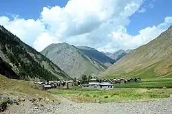
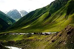 A view of Minimarg village | |
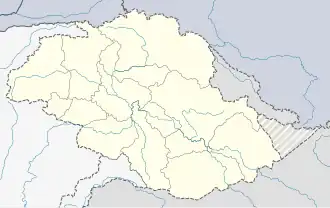 Minimarg Location in Gilgit-Baltistan | |
| Coordinates: 34°47′27″N 75°04′48″E / 34.7908°N 75.0799°E | |
| Country | Pakistan |
| Elevation | 2,844 m (9,331 ft) |
| Time zone | UTC+05:00 (PST) |
| Calling code | +92 - 5817[1] |
Minimarg (Kashmiri: منٕ مرگ; Urdu: منی مرگ) is a village in the Pakistani-administered Kashmir, on the border of the Astore District of Gilgit-Baltistan and the Neelum District of Azad Kashmir. It is situated on the bank of the Burzil Nala, approximately 36 kilometres (22 mi) south of the Chilam Chowki checkpost and to the north of a border village named Kamri.[2] The village, located south of Astore via the Burzil Pass, has an average elevation of 2,844 metres (9,331 ft) above sea level.
History
Minimarg was a part of the Baramulla district before 1947.[3] During the First Kashmir War in 1947–1948, a wing of the combined Gilgit Scouts and renegade 6th Infantry of the Jammu and Kashmir State Forces, called the 'Tiger Force', took control of Minimarg, and it along with 13 other villages of Baramulla district became part of Pakistan.[4][5][3] However, before that the area being an integral part of Gurez valley was known as ‘Gurii’ with respect to Gurez valley. It was also known as ‘Nain’, which means the junction place between Kashmir and Gilgit, and traders used to stay here while travelling to Kashmir and Srinagar. Historically, till 1948, the region had been an ancient trade route between Kashmir valley, and Northern Areas (Gilgit-Baltistan). Moreover, this was the only route through which students and traders used to get access to the Indian side for education and trade. As before 1960s, people of Gilgit had no access to Punjab and other parts of Pakistan, thus they greatly relied on this route.[6]
Etymology
The word "Minimarg" consists of two parts of Kashmiri origin, منٕ, menee which means 'frog' and مرگ, marg which means meadow, hence the name means 'Meadow of Frogs'.[6]
Language
People living in the region speak the Shina language.
Climate
July is warm with an average temperature of 19.8 °C. January is cold with an average temperature of -26.3 °C.[7]
See also
References
- ^ "Dialing Codes". SCO. Retrieved 31 May 2022.
- ^ Anwar, Osman Ehtisham (2 May 2016). "Minimarg: Finding magic near the Line of Control". Dawn. Retrieved 16 August 2025.
- ^ a b Kamili, M. H. "Census of India 1961". Volume VI: Jammu and Kashmir. PART II-A: GENERAL POPULATION TABLES. Published in 1964. The Manager of Publications, Delhi-B. pp. 22.
- ^ Cheema, Brig Amar (2015). The Crimson Chinar: The Kashmir Conflict – A Politico Military Perspective. Lancer Publishers. p. 85. ISBN 978-81-7062-301-4.
- ^ Khanna, K. K. (2015). Art of Generalship. Vij Books India Pvt Ltd. p. 158. ISBN 978-93-82652-93-9.
- ^ a b Sulaiman, Mujahid (30 January 2023). "Socio-Historical Dynamics of Minimarg Valley". The Karakoram. Retrieved 16 August 2025.
- ^ "Minimarg, Azad Jammu and Kashmir". AccuWeather. Retrieved 16 August 2025.