Nasrollah Beyglu
Nasrollah Beyglu
Persian: نصراله بيگلو | |
|---|---|
Village | |
 Nasrollah Beyglu | |
| Coordinates: 39°01′14″N 47°55′50″E / 39.02056°N 47.93056°E[1][2] | |
| Country | Iran |
| Province | Ardabil |
| County | Germi |
| District | Central |
| Rural District | Pain Barzand |
| Population (2016)[3] | |
• Total | 314 |
| Time zone | UTC+3:30 (IRST) |
Nasrollah Beyglu (Persian: نصراله بيگلو)[a] is a village in Pain Barzand Rural District[5] of the Central District in Germi County,[b] Ardabil province, Iran.
Demographics
Population
At the time of the 2006 National Census, the village's population was 417 in 96 households, when it was in Ungut District.[6][c] The following census in 2011 counted 407 people in 109 households.[8] The 2016 census measured the population of the village as 314 people in 92 households.[3]
In 2019, the rural district was transferred to the Central District.[7]
See also
Notes
- ^ Also romanized as Naşrollāh Beyglū[4]
- ^ Formerly Moghan County
- ^ Renamed the Central District of Ungut County[7]
References
- ^ OpenStreetMap contributors (24 February 2025). "نوراله بیگلو [Nurollah Beyglu], Nasrollah Beyglu, دهستان پائین برزند [Pain Barzand Rural District], Central District of Germi County, Germi County, Ardabil Province, Iran" (Map). OpenStreetMap (in Persian). Retrieved 24 February 2025.
- ^ "2WCJ+66F Nasrollah Beyglu, Ardabil Province, Iran" (Map). Google Maps. Retrieved 14 August 2025.
- ^ a b سرشماري عمومي نفوس و مسكن 1395 : استان اردبیل [General Population and Housing Census 2016: Ardabil Province]. مرکز آمار ایران [Statistical Centre of Iran] (in Persian). Archived from the original (Excel) on 22 March 2019. Retrieved 19 June 2025.
- ^ Nasrollah Beyglu can be found at GEOnet Names Server, at this link, by opening the Advanced Search box, entering "111568" in the "Unique Feature Id" form, and clicking on "Search Database".
- ^ Mousavi, Mir-Hossein (9 August 1987) [تاریخ تصویب (Approval date) 1366/05/18 (Iranian Jalali calendar)]. ایجاد و تشکیل تعداد 13 دهستان شامل روستاها، مزارع و مکانها در شهرستان مغان تابع استان آذربایجان شرقی [Creation and formation of 13 rural districts including villages, farms and places in Moghan County under East Azerbaijan province]. لام تا کام [Lam ta Kam] (in Persian). وزارت کشور [Ministry of the Interior]. هیات وزیران [Council of Ministers]. شناسه [ID] 519A4A8A-9894-4AA8-BDC0-B77F45FBF8F6. شماره دوره [Course number] 66, شماره جلد [Volume number] 13. Archived from the original on 18 June 2025. Retrieved 18 June 2025.
- ^ سرشماري عمومي نفوس و مسكن 1385 : استان اردبیل [General Population and Housing Census 2006: Ardabil Province]. مرکز آمار ایران [Statistical Centre of Iran] (in Persian). Archived from the original (Excel) on 20 September 2011. Retrieved 19 June 2025.
- ^ a b Jahangiri, Eshaq (26 February 2019) [تاریخ ابلاغ (Notification date) 1397/12/07 (Iranian Jalali calendar)]. تصویب نامه در خصوص تقسیمات کشوری در شهرستانهای جم، کنگان در استان بوشهر [Approval letter regarding national divisions in Germi County of Ardabil province]. مرکز پژوهشهای مجلس شورای اسلامی ایران [Research Center of the Islamic Consultative Assembly of Iran] (in Persian). وزارت کشور [Ministry of the Interior]. هیات وزیران [Council of Ministers]. شماره ابلاغیه : ۱۶۴۱۸۲/ت۵۵۷۴۱ه [Notification Number: 164182/T55741H. Archived from the original on 24 June 2021. Retrieved 19 June 2025.
- ^ سرشماري عمومي نفوس و مسكن 1390 : استان اردبیل [General Population and Housing Census 2011: Ardabil Province]. Iran Data Portal—Syracuse University (in Persian). مرکز آمار ایران [Statistical Centre of Iran]. Archived from the original (Excel) on 15 January 2023. Retrieved 19 June 2025.
| Capital | 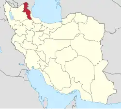 | ||||||||||||||||||||||
|---|---|---|---|---|---|---|---|---|---|---|---|---|---|---|---|---|---|---|---|---|---|---|---|
| Counties and cities |
| ||||||||||||||||||||||
| Landmarks |
| ||||||||||||||||||||||
| Places | |||||||||||||||||||||||