Plesná (Ostrava)
Plesná | |
|---|---|
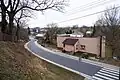
 Panoramic view of Plesná | |
 Flag  Coat of arms | |
 Location of Plesná in Ostrava | |
| Coordinates: 49°51′48″N 18°08′52″E / 49.8634°N 18.1478°E | |
| Country | Czech Republic |
| Region | Moravian-Silesian Region |
| City | Ostrava |
| Area | |
• Total | 4.84 km2 (1.869 sq mi) |
| Population (2021)[1] | |
• Total | 1,496 |
| • Density | 310/km2 (800/sq mi) |
| Time zone | UTC+1 (CET) |
| • Summer (DST) | UTC+2 (CEST) |
| Postal code | 725 27 |
| Website | https://plesna.ostrava.cz/cs |
Plesná is a borough and municipal district of the city of Ostrava, Czech Republic, situated in the north-western part of the city. Originally, it was a separate village, until it merged with the city borough Poruba in 1976.[2][3] On 1 January 1994, Plesná was separated from Poruba, and became one of the 23 self-governing boroughs of Ostrava.[4]
Etymology
The word is derived from the Old Czech word for a lake – ples.[5][6]
Gallery
-
 26. dubna street in Plesná
 -
 Wooden statue “čumil osminohý” (eight-legged gaper) in Plesná
 -
 Forest in Plesná
References
- ^ "Results of the 2021 Census - Open data". Public Database (in Czech). Czech Statistical Office. 27 March 2021.
- ^ "Plesná - Historie obce". www.mistopisy.cz. Retrieved 9 July 2025.
- ^ "Historie". Ostrava.cz (in Czech). Retrieved 9 July 2025.
- ^ "Ostravské městské obvody – eOstrava.cz" (in Czech). Retrieved 6 July 2025.
- ^ "Symboly obvodu". Ostrava.cz (in Czech). Retrieved 9 July 2025.
- ^ "ČJA". cja.ujc.cas.cz. Retrieved 9 July 2025.