Portal:Myanmar
ကြိုဆိုပါတယ်။ / Welcome to the Myanmar Portal 
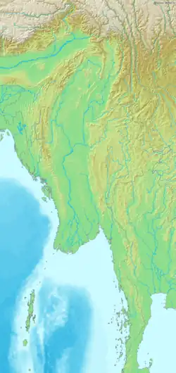
Myanmar, officially the Republic of the Union of Myanmar and also referred to as Burma (the official English name until 1989), is a country in northwest Southeast Asia. It is the largest country by area in Mainland Southeast Asia and has a population of about 55 million. It is bordered by India and Bangladesh to the northwest, China to the northeast, Laos and Thailand to the east and southeast, and the Andaman Sea and the Bay of Bengal to the south and southwest. The country's capital city is Naypyidaw, while its largest city is Yangon (formerly Rangoon).
Myanmar is a member of the East Asia Summit, Non-Aligned Movement, ASEAN, and BIMSTEC, but it is not a member of the Commonwealth of Nations despite once being part of the British Empire. Myanmar is a Dialogue Partner of the Shanghai Cooperation Organization. The country is very rich in natural resources, such as jade, gems, oil, natural gas, teak and other minerals, as well as endowed with renewable energy, having the highest solar power potential compared to other countries of the Great Mekong Subregion. However, Myanmar has long suffered from instability, factional violence, corruption, poor infrastructure, as well as a long history of colonial exploitation with little regard to human development. In 2013, its GDP (nominal) stood at US$56.7 billion and its GDP (PPP) at US$221.5 billion. The income gap in Myanmar is among the widest in the world, as a large proportion of the economy is controlled by cronies of the military junta. Myanmar is one of the least developed countries. Since 2021, more than 600,000 people have been displaced across Myanmar due to the civil war post-coup, with more than three million people in dire need of humanitarian assistance. According to the United Nations High Commissioner for Refugees (UNHCR), there are over 1.3 million people counted as refugees and asylum seekers, and 3.5 million people displaced internally as of December 2024. (Full article...)
Selected articles -
-

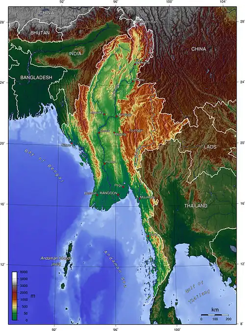
Myanmar (also known as Burma) is the northwesternmost country of mainland Southeast Asia located on the Indochinese peninsula. With an area of 261,228 sq mi (676,578 km2), it is the second largest country in Southeast Asia and the largest on mainland Southeast Asia. The kite-shaped country stretches from 10'N to 20'N for 1,275 miles (2,050 km) with a long tail running along the western coast of the Malay Peninsula.
Myanmar lies along the Indian and Eurasian Plates, to the southeast of the Tibetan Plateau. To its west is the Bay of Bengal and to its south is the Andaman Sea. The country is nestled between several mountain ranges with the Arakan Mountains on the west and the Shan Plateau dominating the east. The central valley follows the Irrawaddy River, the most economically important river to the country with 39.5 million people, including the largest city Yangon, living within its basin. The country is home to many diverse ethnic groups, with 135 officially recognized groups. It is strategically located near major Indian Ocean shipping lanes and was historically home to overland trade routes into China from the Bay of Bengal. The neighboring countries are China, India, Bangladesh, Thailand and Laos. (Full article...) -
The economy of Myanmar is the seventh largest in Southeast Asia. After the return of civilian rule in 2011, the new government launched large-scale reforms, focused initially on the political system to restore peace and achieve national unity and moving quickly to an economic and social reform program. Current economic statistics were a huge decline from the economic statistics of Myanmar in the fiscal year of 2020, in which Myanmar’s nominal GDP was $81.26 billion and its purchasing power adjusted GDP was $312.49 billion. Myanmar has faced an economic crisis since the 2021 coup d'état. According to the International Monetary Fund (IMF), Myanmar's GDP per capita in 2024 was $1,110. (Full article...) -
Myint Myint Khin FRCP (Burmese: မြင့်မြင့်ခင်, pronounced [mjɪ̰ɰ̃ mjɪ̰ɰ̃ kʰɪ̀ɰ̃]; 15 December 1923 – 19 June 2014) was a Burmese medical professor and writer. An English major at the University of Rangoon, she was the chair of the Department of Medicine of the Institute of Medicine, Mandalay from 1965 to 1984, and served as a consultant at the World Health Organization from 1985 to 1991. Her literary career began in 1996, spurred on by the HIV/AIDS crisis in the country. She published 11 books in Burmese and two in English. At the time of her death, the former professor was collaborating on an English language book on the history of medical education in the country.
Most of her books dealt with public health and medicine. One notable exception was her last published book in 2013, Poetry for Me, a collection of her English language poetry, which she began working on after the death of her husband Dr. San Baw, a hip replacement pioneer, in 1984. Through her books and interviews, she advocated for more openness and transparency in the country, and spoke out about the regression of women's rights in Myanmar. In 2012, she founded a daycare center for elderly physicians in Yangon. (Full article...) -
The Myanmar civil war (Burmese: မြန်မာ့ပြည်တွင်းစစ်), also known as the Burmese civil war, is an ongoing civil war since 2021. It began following Myanmar's long-running insurgencies, which escalated significantly in response to the 2021 coup d'état and the subsequent violent crackdown on anti-coup protests. The exiled National Unity Government (NUG) and major ethnic armed organisations repudiated the 2008 Constitution and called instead for a democratic federal state. Besides engaging this alliance, the ruling government of the State Administration Council (SAC), also contends with other anti-SAC forces in areas under its control. The insurgents are apportioned into hundreds of armed groups scattered across the country.
As of March 2023 the United Nations estimated that since the coup in February 2021, 17.6 million people in Myanmar required humanitarian assistance, while 1.6 million were internally displaced, and over 55,000 civilian buildings had been destroyed. The United Nations Office for the Coordination of Humanitarian Affairs (UNOCHA) said that over 40,000 people had fled into neighboring countries, such as Bangladesh, India and Thailand. (Full article...) -
_map_-_EN_-_001.jpg)
The Burmese–Siamese War of 1765–1767, also known as the war of the second fall of Ayutthaya (Thai: สงครามคราวเสียกรุงศรีอยุธยาครั้งที่สอง) was the second military conflict between Burma under the Konbaung dynasty and Ayutthaya Kingdom under the Siamese Ban Phlu Luang dynasty that lasted from 1765 until 1767; the war ended the 417-year-old Ayutthaya Kingdom.
Burma under the new Konbaung dynasty emerged powerful in the mid-18th century. King Alaungpaya, the dynastic founder, led his Burmese forces of 40,000 men, and with his son Prince of Myedu as vanguard commander, invaded Siam in late 1759 to early 1760. The Burmese reached and attacked Ayutthaya in April 1760 but the arrival of rainy season and sudden illness of Alaungpaya prompted the Burmese to retreat. The traditional Siamese strategy of passive stand in the Ayutthaya citadel against Burmese besiegers worked for one last time, postponing the eventual fall of Ayutthaya for seven years. Alaungpaya died in May 1760 on his way from Siam back to Burma. Burmese invasion of Siam in 1760, in which the Burmese, particularly Prince Myedu, had an opportunity to learn about Siamese geography, strategy and tactics and to reflect about their own flaws in the campaign, served as the foundation of the next Burmese invasion in 1765–1767. Prince Myedu ascended the Burmese throne as King Hsinbyushin in late 1763. Hsinbyushin inherited military energy and prowess from his father Alaungpaya and was determined to accomplish his father's unfinished mission of conquering Ayutthaya. (Full article...) -
Indawgyi Lake Wildlife Sanctuary is a biosphere reserve in Myanmar, covering 814.99 km2 (314.67 sq mi). It ranges in elevation from 105–1,400 m (344–4,593 ft) encompassing the surroundings of Indawgyi Lake in Mohnyin Township, Kachin State. It was gazetted in 2004, is recognized as an Important Bird Area and as one of the ASEAN Heritage Parks.
An area of 478.84 km2 (184.88 sq mi) comprising the lake and the surrounding lowland is a Ramsar site since February 2016.
During a survey in the winter of 2004, both resident and migratory birds were sighted on the lake and along Indawgyi River, including white-rumped vulture (Gyps bengalensis), slender-billed vulture (G. tenuirostris), Himalayan vulture (G. himalayensis), lesser whistling duck (Dendrocygna javanica), tufted duck (Aythya fuligula), ferruginous pochard (A. nyroca), gadwall (Mareca strepera), ruddy shelduck (Tadorna ferruginea), Eurasian teal (Anas crecca), northern pintail (A. acuta), greylag goose (Anser anser), Eurasian coot (Fulica atra), little grebe (Tachybaptus ruficollis), great crested grebe (Podiceps cristatus), little cormorant (Microcarbo niger), purple heron (Ardea purpurea), brown-headed gull (Chroicocephalus brunnicephalus), black-headed gull (C. ridibundus), wood sandpiper (Tringa glareola), Temminck's stint (Calidris temminckii), black-winged stilt (Himantopus himantopus), grey-headed lapwing (Vanellus cinereus) and glossy ibis (Plegadis falcinellus). (Full article...) -
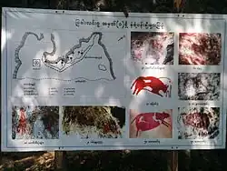
The Padah-Lin Caves (Burmese: ဗဒလင်းဂူ, pronounced [bədəlíɰ̃ ɡù]; also Padalin or Badalin) are limestone caves located in Taunggyi District, Shan State, Burma (Myanmar). It is located near a path from Nyaunggyat to Yebock, on a spur of the Nwalabo mountains within the Panlaung Reserved Forest. There are two caves; the smaller of the two is a rock shelter while the larger cave comprises nine chambers connected by narrow passages in a north-south axis, three large sinkholes that let natural light in, and several active speleothem formations. (Full article...) -
The Battle of the Sittang Bend and the Japanese Breakout across Pegu Yomas were linked Japanese military operations during the Burma Campaign, which took place nearly at the end of World War II. Surviving elements of the Imperial Japanese Army who had been driven into the Pegu Yoma attempted to break out eastwards in order to join other Japanese troops retreating from the British forces. The break-out was the objective of the Japanese Twenty-Eighth Army with support at first from the Thirty-Third Army and later the Fifteenth Army. As a preliminary, the Japanese Thirty-Third Army attacked Allied positions in the Sittang Bend, near the mouth of the river, to distract the Allies. The British had been alerted to the break-out attempt and it ended calamitously for the Japanese, who suffered many losses, with some formations being wiped out.
There were around 14,000 Japanese casualties, with well over half being killed, while British forces suffered only 95 killed and 322 wounded. The break-out attempt and the ensuing battle became the last significant land battle of the Western powers in the Second World War. (Full article...) -

The Myanmar Air Force (Burmese: တပ်မတော် (လေ), romanized: Tatmadaw (Lay), lit. 'Armed Forces (Air Force)', pronounced [taʔmədɔ̀ (le)]) is the aerial branch of the Tatmadaw, the armed forces of Myanmar. The primary mission of the Myanmar Air Force (MAF) since its inception has been to provide air bases force protection, anti-aircraft warfare, close air support (CAS), logistical, and transport to the Myanmar Army in counterinsurgency operations. It is mainly used in internal conflicts in Myanmar, and, on a smaller scale, in relief missions, especially after the deadly Cyclone Nargis of May 2008. (Full article...) -
The People's Defence Force is the armed wing of the National Unity Government (NUG) in Myanmar. The armed wing was formed by the NUG from youths and pro-democracy activists on 5 May 2021 in response to the coup d'état that occurred on 1 February 2021 that put the military junta and their armed wing the Tatmadaw in power. The military junta designated it as a terrorist organisation on 8 May 2021. In October 2021, NUG's Ministry of Defence announced that it had formed a central committee to coordinate military operations across the country.
According to the NUG statement, the PDF is divided into five regional commands (Northern, Southern, Central, Eastern and Western commands), each mounting at least three brigades. Each brigade consists of five battalions, which divide into four companies. On 13 July 2021, NUG's minister of defence Yee Mon stated that the strength of the newly-formed militia was expected to reach 8,000 by the end of the month. Estimates by The Irrawaddy put the PDF's numbers at 65,000 in November 2022. More recent estimates put the PDF's strength at 100,000, even though not all are believed to be fully armed and trained. The PDF's leadership endorse guerrilla warfare tactics in pursuit of their aims. The military often called People Defence Force (PDF) as "ပဒတ်", especially during early years of formation, mainly due to their implementation of small, fragmented and guerilla warfare tactics with less sophisticated weapons. (Full article...)


Did you know (auto-generated) -

- ... that the Burmese Buddhist monk Sagyo Thu-Myat successfully lobbied for the recalibration of the Burmese calendar?
- ... that Molly Burman resumed releasing music three years later after finding that "Happy Things" had accrued a million streams on Spotify?
- ... that the government's Visit Myanmar Year initiative caused Aung San Suu Kyi to encourage a tourism boycott?
- ... that the DI MA-1 Mk. III rifle was made in Myanmar as a reverse-engineered copy of the Chinese QBZ-97?
- ... that Burma the elephant once escaped Auckland Zoo?
- ... that one academic described the introduction of femboys to Myanmar as a tactic to achieve an "ideological revolution"?
- ... that Maung O, Prince of Salin, and his sister Nanmadaw Me Nu became de facto rulers of Burma when King Bagyidaw was suffering from depression?
- ... that Rolling Stone named Mission of Burma's "Academy Fight Song" as one of the 100 greatest debut singles of all time?
Related portals and projects
Southeast Asia
Other Countries
![]() WikiProject Myanmar
WikiProject Myanmar
![]() WikiProject Southeast Asia
WikiProject Southeast Asia
![]() WikiProject Asia
WikiProject Asia
General images -
-
.jpg) First Anglo-Burmese War in 1824 (from History of Myanmar)
First Anglo-Burmese War in 1824 (from History of Myanmar) -
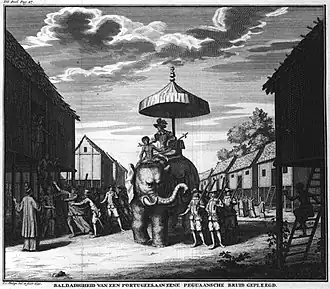 Portuguese ruler and soldiers mounting an elephant. Jan Caspar Philips (draughtsman and engraver). (from History of Myanmar)
 -
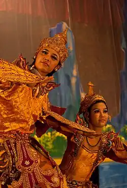 A theatrical performance of the Mon dance (from Culture of Myanmar)
 -
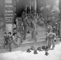 British soldiers remove their shoes at the entrance of Shwedagon Pagoda. To the left, a sign reads "Foot wearing is strictly prohibited" in Burmese, English, Tamil, and Urdu. (from Culture of Myanmar)
 -
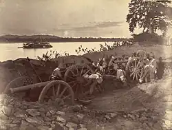 British soldiers dismantling cannons belonging to King Thibaw's forces, Third Anglo-Burmese War, Ava, 27 November 1885. Photographer: Hooper, Willoughby Wallace (1837–1912). (from History of Myanmar)
 -
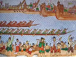 Hlei pyaingbwè - a Burmese regatta (from Culture of Myanmar)
 -
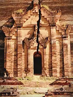 A large fracture on the Mingun Pahtodawgyi caused by the 1839 Ava earthquake. (from Geography of Myanmar)
 -
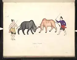 A bull fight, 19th-century watercolour (from Culture of Myanmar)
 -
![Image 9Military situation in Myanmar as of 2024[update]. Areas controlled by the Tatmadaw are highlighted in red. (from History of Myanmar)](./_assets_/Myanmar_civil_war.svg.png) Military situation in Myanmar as of 2024. Areas controlled by the Tatmadaw are highlighted in red. (from History of Myanmar)
Military situation in Myanmar as of 2024. Areas controlled by the Tatmadaw are highlighted in red. (from History of Myanmar) -
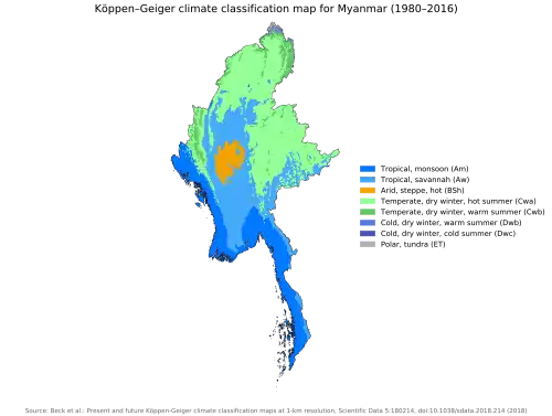 Myanmar (Burma) map of Köppen climate classification (from Geography of Myanmar)
 -
 Myinhkin thabin - equestrian sport (from Culture of Myanmar)
 -
 Former US President Barack Obama poses barefoot on the grounds of Shwedagon Pagoda, one of Myanmar's major Buddhist pilgrimage sites. (from Culture of Myanmar)
 -
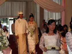 A wedding procession, with the groom and bride dressed in traditional Burmese wedding clothes, reminiscent of royal attire (from Culture of Myanmar)
 -

-
_headquarter.jpg) Aung San Suu Kyi addresses crowds at the NLD headquarters shortly after her release. (from History of Myanmar)
Aung San Suu Kyi addresses crowds at the NLD headquarters shortly after her release. (from History of Myanmar) -
-
.jpg) Salween river at Mae Sam Laep on the Thai-Myanmar border (from Geography of Myanmar)
Salween river at Mae Sam Laep on the Thai-Myanmar border (from Geography of Myanmar) -
 Boxing match, 19th-century watercolour (from Culture of Myanmar)
 -
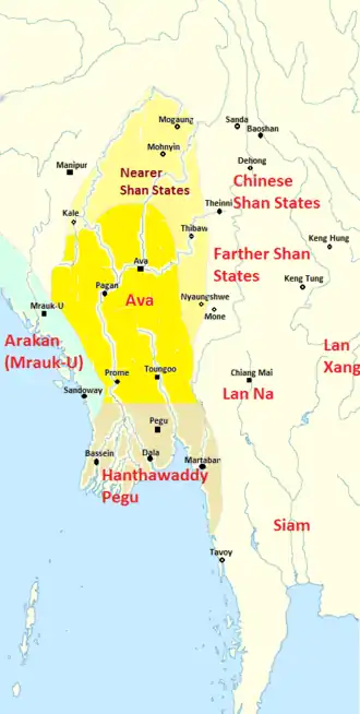
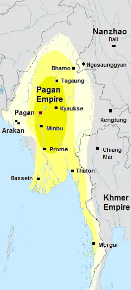 Pagan Kingdom during Narapatisithu's reign. Burmese chronicles also claim Kengtung and Chiang Mai. Core areas shown in darker yellow. Peripheral areas in light yellow. Pagan incorporated key ports of Lower Burma into its core administration by the 13th century. (from History of Myanmar)
 -
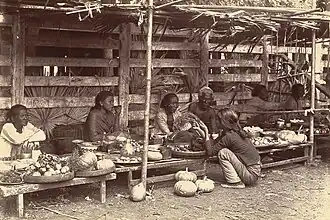 Vegetable stall on the roadside at the Madras Lancer Lines, Mandalay, January 1886. Photographer: Hooper, Willoughby Wallace (1837–1912). (from History of Myanmar)
 -
 Aerial view of a burned Rohingya village in Rakhine state, September 2017 (from History of Myanmar)
 -
-
 Recorder's Court on Sule Pagoda Road, with the Sule Pagoda at the far end, Rangoon, 1868. Photographer: J. Jackson. (from History of Myanmar)
 -
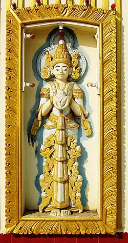
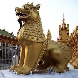 Sculpture of Myanmar mythical lion (from Culture of Myanmar)
 -
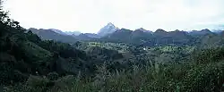 Mountains near Pindaya on the Shan Plateau (from Geography of Myanmar)
 -
 Two female musicians play the saung at a performance in Mandalay. (from Culture of Myanmar)
 -
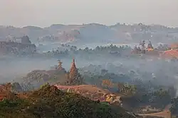 Temples at Mrauk U, the capital of the Mrauk U Kingdom, which ruled over what is now Rakhine State (from History of Myanmar)
 -
 Grandfather Island, Dawei (from Geography of Myanmar)
 -
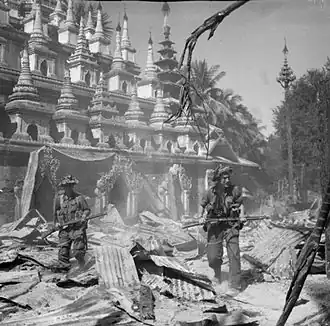 British soldiers on patrol in the ruins of the Burmese town of Bahe during the advance on Mandalay, January 1945 (from History of Myanmar)
 -
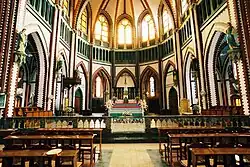 Saint Mary's Cathedral in Downtown Yangon is the largest Roman Catholic cathedral in Burma. (from Culture of Myanmar)
 -
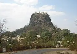 Mount Popa, a dormant volcano in the Central Lowlands (from Geography of Myanmar)
 -
-
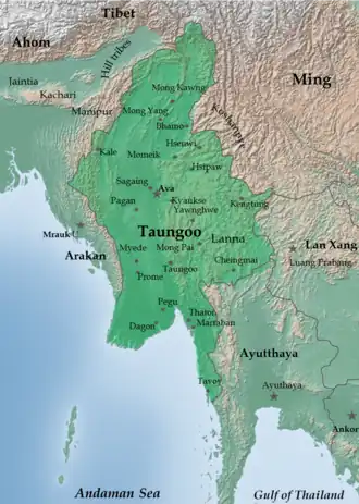 The restored Taungoo or Nyaungyan dynasty, c. 1650 CE (from History of Myanmar)
 -
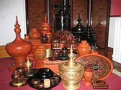 A wide range of Burmese lacquerware from Bagan (from Culture of Myanmar)
 -
 Political map of Burma (Myanmar) c. 1450 CE. (from History of Myanmar)
 -
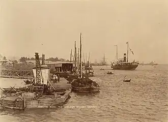 The paddle steamer Ramapoora (right) of the British India Steam Navigation Company on the Rangoon river having just arrived from Moulmein. 1895. Photographers: Watts and Skeen. (from History of Myanmar)
 -
 The shores of Irrawaddy River at Nyaung-U, Bagan (from Geography of Myanmar)
 -
 Jade Mine in Hpakant (from Geography of Myanmar)
 -
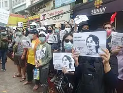 Protesters in Yangon carrying signs reading "Free Daw Aung San Suu Kyi" on 8 February 2021 (from History of Myanmar)
 -
 19th-century funeral cart and spire, which would form part of the procession from the home to the place of cremation (from Culture of Myanmar)
 -
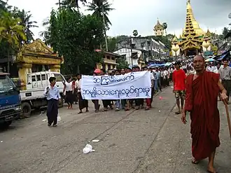 Protesters in Yangon with a banner that reads "non-violence: national movement" in Burmese. In the background is Shwedagon Pagoda. (from History of Myanmar)
 -
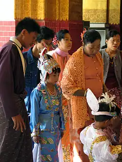
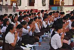 A group of Buddhist worshipers at Shwedagon Pagoda, an important religious site for Burmese Buddhists (from Culture of Myanmar)
Major topics
Categories

More topics
Associated Wikimedia
The following Wikimedia Foundation sister projects provide more on this subject:
-
 Commons
Free media repository -
 Wikibooks
Free textbooks and manuals -
 Wikidata
Free knowledge base -
 Wikinews
Free-content news -
 Wikiquote
Collection of quotations -
 Wikisource
Free-content library -
 Wikiversity
Free learning tools -
 Wikivoyage
Free travel guide -
 Wiktionary
Dictionary and thesaurus
More portals
-
 List of all portals
 -

-

-

-

-

-

-

-

-

-
 Random portal
 -
 WikiProject Portals