Reber, Kamnik
Reber | |
|---|---|
 | |
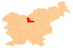
 Reber Location in Slovenia | |
| Coordinates: 46°13′53″N 14°52′22″E / 46.23139°N 14.87278°E | |
| Country | |
| Traditional region | Upper Carniola |
| Statistical region | Central Slovenia |
| Municipality | Kamnik |
| Elevation | 610 m (2,000 ft) |
Reber (pronounced [ˈɾeːbəɾ], in older sources also Rebro)[2] is a former settlement in the Municipality of Kamnik in central Slovenia. It is now part of the village of Bela.[3] The area is part of the traditional region of Upper Carniola. The municipality is now included in the Central Slovenia Statistical Region.
Geography
Reber stands on the sunny side of a slope about 2 kilometers (1.2 mi) north of the main road from Kamnik to Motnik.[1]
Name
The name Reber is derived from the common noun reber 'slope, hillside', reflecting its geographical position. It is a relatively common name in Slovenia, as both a toponym and an oronym.[4] The former village of Reber lies on a slope rising from the Motnišnica Valley to the Menina Pasture Plateau.
History
Reber was annexed by Bela in 1953, ending its existence as an independent settlement.[5]
References
- ^ a b Krajevni leksikon Dravske Banovine. 1937. Ljubljana: Zveza za tujski promet za Slovenijo, p. 200.
- ^ Leksikon občin kraljestev in dežel zastopanih v državnem zboru, vol. 6: Kranjsko (PDF). Vienna: C. Kr. Dvorna in Državna Tiskarna. 1906. p. 30.
- ^ Savnik, Roman (1971). Krajevni leksikon Slovenije, vol. 2. Ljubljana: Državna založba Slovenije. p. 179.
- ^ Snoj, Marko (2009). Etimološki slovar slovenskih zemljepisnih imen. Ljubljana: Modrijan. p. 350.
- ^ Marinković, Dragan (1991). Abecedni spisak naselja u SFRJ. Promene u sastavu i nazivima naselja za period 1948–1990. Belgrade: Savezni zavod za statistiku. pp. 4, 87.
External links
 Media related to Reber at Wikimedia Commons
- Reber on Geopedia