San Joaquin, Iloilo
San Joaquin
Suaraga | |
|---|---|
| Municipality of San Joaquin | |
.jpg) San Joaquin Church | |
 Flag _Municipal_Seal.png) Seal | |
 Map of Iloilo with San Joaquin highlighted | |
OpenStreetMap | |
.svg.png) San Joaquin Location within the Philippines | |
| Coordinates: 10°36′N 122°05′E / 10.6°N 122.08°E | |
| Country | Philippines |
| Region | Western Visayas |
| Province | Iloilo |
| District | 1st district |
| Founded | 1692 |
| Reincorporated | December 10, 1910 |
| Barangays | 85 (see Barangays) |
| Government | |
| • Type | Sangguniang Bayan |
| • Mayor | Joe Abad S. Lazaro Jr. (Liberal) |
| • Vice Mayor | Ivy Mae T. Selibio-Crespo (Lakas) |
| • Representative | Janette L. Garin (Lakas) |
| • Municipal Council | Members |
| • Electorate | 32,684 voters (2025) |
| Area | |
• Total | 234.84 km2 (90.67 sq mi) |
| Elevation | 75 m (246 ft) |
| Highest elevation | 1,043 m (3,422 ft) |
| Lowest elevation | 0 m (0 ft) |
| Population (2024 census)[3] | |
• Total | 52,773 |
| • Density | 220/km2 (580/sq mi) |
| • Households | 12,752 |
| Demonym | San Joaquinhons |
| Economy | |
| • Income class | 1st municipal income class |
| • Poverty incidence | 27.81 |
| • Revenue | ₱ 274.4 million (2022) |
| • Assets | ₱ 940.5 million (2022) |
| • Expenditure | ₱ 152.1 million (2022) |
| • Liabilities | ₱ 148.6 million (2022) |
| Service provider | |
| • Electricity | Iloilo 1 Electric Cooperative (ILECO 1) |
| • Water | San Joaquin Water District (SJWD) |
| Time zone | UTC+8 (PST) |
| ZIP code | 5024 |
| PSGC | |
| IDD : area code | +63 (0)33 |
| Native languages | Karay-a Hiligaynon Ati Tagalog |
| Feast date |
|
| Catholic diocese | Archdiocese of Jaro |
| Patron saint | Saint Joachim |
San Joaquin, officially the Municipality of San Joaquin (Kinaray-a: Banwa kang San Joaquin; Hiligaynon: Banwa sang San Joaquin; Tagalog: Bayan ng San Joaquin, IPA: [sɐn (h)waˈkin]), is a municipality in the province of Iloilo, Philippines. According to the 2024 census, it has a population of 52,773 people.[5]
History
Spanish Colonial Period
The history of San Joaquin, Iloilo, can be traced back to the late 17th century, with significant developments in its religious and civic structure. According to historical records, the town’s foundation is marked by a series of key events related to its missionary history.
In 1687, San Joaquin was assigned its own minister, which signified the town’s initial formal recognition by the church. However, the minister only stayed for a year before the settlement became a Visita—a mission station that lacked a permanent parish priest. The town remained as a Visita until 1692, when it was officially established as a parish. During this period, San Joaquin was under the ecclesiastical jurisdiction of Miagao.
The 1692 date is widely considered the certain foundation date of San Joaquin as a parish, according to sources like Juan Fernandez's Monografías de los pueblos de la isla de Pan-ay and Elviro Jorde's Catálogo bio bibliográfico.
Fr. Felipe Alfaraz, a notable Augustinian missionary, played a significant role in the town’s religious history. According to Jorde’s Misión 65 (1788), Fr. Alfaraz was assigned as parish priest to several towns, including San Joaquin in 1794, having previously served in Lambunao (1790) and Guimbal (1801). One enduring legacy of this era is the San Joaquin Roman Catholic Church, which was completed in 1869 and declared a national shrine in September 1977.
American Colonial Period
After the Spanish-American War and the establishment of American rule in the Philippines, significant changes were introduced in the governance and administrative structures of towns in Iloilo, including San Joaquin. The American colonization introduced new administrative systems that aimed to streamline governance and adapt the region to Western-style municipal structures. The consolidation of municipalities became a key aspect of this process.
On April 11, 1901, the American colonial government officially organized the civil government of Iloilo Province, which initially included 50 municipalities. These municipalities were placed under the supervision of the new American administration, with a goal of bringing order and structure to the region. San Joaquin was one of the towns included in the initial organization of municipalities, albeit a relatively smaller and less economically developed town compared to others in the province.
In a move to further streamline governance, the American government passed Act No. 719 on April 4, 1903, which aimed to reduce the number of municipalities in Iloilo from 50 to just 17. The law officially read: "AN ACT REDUCING THE FIFTY-ONE MUNICIPALITIES OF THE PROVINCE OF ILOILO TO SEVENTEEN." This consolidation resulted in the merging of smaller and economically less prosperous towns, including San Joaquin, which was incorporated into the larger and more affluent Miagao.
As a result of this act, many smaller towns were relegated to being suburbs (arrabals) of larger municipalities. Although San Joaquin was now part of Miagao, its identity remained intact, and it continued to serve as an important part of the region’s cultural and historical fabric.
Despite its inclusion in Miagao, the town of San Joaquin did not lose its drive for independence. In 1908, Eliseo J. Sanglap, a prominent native of San Joaquin, was elected Municipal President of Miagao. Sanglap advocated strongly for the restoration of San Joaquin’s autonomy, leading to the passage of Executive Order No. 21 by the American Military Governor General on December 10, 1910. This order officially restored San Joaquin as an independent municipality.
The restoration of San Joaquin was a significant victory for the local people and marked the town’s reclamation of its municipal status after being absorbed into Miagao. With this newfound independence, San Joaquin was able to re-establish its local governance and continue developing under the American colonial system.
Separation of Lawigan and Reversion
On July 10, 1961, President Carlos P. Garcia issued Executive Order No. 436, which created the municipality of Lawigan in the province of Iloilo, carving it out of several barrios and sitios from San Joaquin. The newly-formed municipality of Lawigan was composed of the following areas: Lawigan, Sinogbuhan, Cataan, Igcundao, Langwanan, San Luis, San Gregorio, Igbangcal, Mabini, Andres Bonifacio, Igcoris, Igbaje, Balabago, Amboyuan, Dacdacanan, Igcabotong, San Mateo, Talagutac, Nagquirisan, Gumawan, and Igdumingding.
The boundary between the two municipalities was defined by the Tiolas River, with the separation starting at its mouth and continuing along the river’s course upstream, passing through the Quianan bridge in Pitogo and along the Iloilo-Antique inter-provincial road up to the provincial boundary at Dawis.
However, the legality of Executive Order No. 436 was challenged by the Municipality of San Joaquin, which argued that the creation of Lawigan was an undue delegation of legislative powers, rendering the order unconstitutional. In G.R. No. L-19870, on March 18, 1967, the Supreme Court ruled in favor of San Joaquin, declaring Executive Order No. 436 null and void ab initio (from the beginning). The Court reasoned that the creation of municipalities is an essentially legislative function, not an administrative one, and that the law violated constitutional principles.
As a result of the ruling, the barrios and sitios that had been part of Lawigan were reverted back to San Joaquin, and Lawigan once again became a part of San Joaquin, Iloilo. The people of Lawigan, however, continued to thrive as part of San Joaquin, with the area remaining a prosperous village and the site of the Our Lady of Salvation Parish.
Currently, San Joaquin is subdivided into 85 barangays, with Lawigan being one of the most prominent, contributing to the town's cultural, religious, and economic life.
Geography
San Joaquin is located at the southern tip of Iloilo Province. One of the rivers that traverse the town is the Siwaragan River, with Barangays Siwaragan and Bucaya situated at its mouth. It is the southernmost municipality in the province, located 53 kilometres (33 mi)[6] from the provincial capital, Iloilo City, and is 44 kilometres (27 mi) from San Jose de Buenavista, the capital of Antique.

Climate
| Climate data for San Joaquin, Iloilo | |||||||||||||
|---|---|---|---|---|---|---|---|---|---|---|---|---|---|
| Month | Jan | Feb | Mar | Apr | May | Jun | Jul | Aug | Sep | Oct | Nov | Dec | Year |
| Mean daily maximum °C (°F) | 30 (86) |
31 (88) |
32 (90) |
33 (91) |
32 (90) |
30 (86) |
29 (84) |
29 (84) |
29 (84) |
29 (84) |
30 (86) |
30 (86) |
30 (87) |
| Mean daily minimum °C (°F) | 21 (70) |
21 (70) |
22 (72) |
23 (73) |
25 (77) |
25 (77) |
25 (77) |
24 (75) |
24 (75) |
24 (75) |
23 (73) |
22 (72) |
23 (74) |
| Average precipitation mm (inches) | 19 (0.7) |
17 (0.7) |
26 (1.0) |
37 (1.5) |
119 (4.7) |
191 (7.5) |
258 (10.2) |
260 (10.2) |
248 (9.8) |
196 (7.7) |
97 (3.8) |
39 (1.5) |
1,507 (59.3) |
| Average rainy days | 7.2 | 5.2 | 8.3 | 11.9 | 22.3 | 26.5 | 28.3 | 28.2 | 27.3 | 26.4 | 18.7 | 11.8 | 222.1 |
| Source: Meteoblue[7] | |||||||||||||
Barangays
San Joaquin is politically subdivided into 85 barangays.[8] Each barangay consists of puroks and some have sitios.
| PSGC | Barangay | Population | ±% p.a. | |||
|---|---|---|---|---|---|---|
| 2024[9] | 2010[10] | |||||
| 063040001 | Amboyu-an | 2.4% | 1,278 | 1,046 | 1.41% | |
| 063040002 | Andres Bonifacio | 0.8% | 435 | 468 | −0.51% | |
| 063040003 | Antalon | 1.0% | 529 | 530 | −0.01% | |
| 063040004 | Bad-as | 0.5% | 273 | 258 | 0.40% | |
| 063040005 | Bagumbayan | 1.4% | 731 | 599 | 1.40% | |
| 063040006 | Balabago | 2.4% | 1,270 | 1,139 | 0.76% | |
| 063040007 | Baybay | 1.9% | 1,003 | 756 | 2.00% | |
| 063040008 | Bayunan (Panday Oro) | 1.2% | 651 | 674 | −0.24% | |
| 063040010 | Bolbogan | 0.8% | 448 | 389 | 0.99% | |
| 063040011 | Bulho | 1.0% | 516 | 454 | 0.90% | |
| 063040012 | Bucaya | 3.3% | 1,732 | 1,691 | 0.17% | |
| 063040013 | Cadluman | 0.4% | 207 | 198 | 0.31% | |
| 063040014 | Cadoldolan | 0.9% | 491 | 408 | 1.30% | |
| 063040015 | Camia | 0.7% | 392 | 364 | 0.52% | |
| 063040016 | Camaba-an | 0.5% | 251 | 251 | 0.00% | |
| 063040017 | Cata-an | 2.4% | 1,276 | 1,256 | 0.11% | |
| 063040018 | Crossing Dapuyan | 1.8% | 939 | 976 | −0.27% | |
| 063040019 | Cubay | 0.7% | 385 | 456 | −1.18% | |
| 063040020 | Cumarascas | 0.5% | 257 | 257 | 0.00% | |
| 063040021 | Dacdacanan | 0.8% | 420 | 491 | −1.09% | |
| 063040022 | Danawan | 0.6% | 302 | 319 | −0.38% | |
| 063040024 | Doldol | 0.9% | 454 | 429 | 0.40% | |
| 063040025 | Dongoc | 1.8% | 936 | 692 | 2.13% | |
| 063040026 | Escalantera (Dawis) | 1.7% | 892 | 795 | 0.81% | |
| 063040027 | Ginot-an | 1.5% | 794 | 832 | −0.33% | |
| 063040029 | Huna | 0.5% | 281 | 209 | 2.09% | |
| 063040030 | Igbaje | 0.5% | 262 | 323 | −1.45% | |
| 063040031 | Igbangcal | 0.6% | 332 | 467 | −2.36% | |
| 063040032 | Igbinangon | 0.5% | 286 | 231 | 1.50% | |
| 063040033 | Igburi | 1.0% | 529 | 479 | 0.70% | |
| 063040034 | Igcabutong | 0.3% | 184 | 247 | −2.04% | |
| 063040035 | Igcadlum | 1.0% | 554 | 485 | 0.93% | |
| 063040036 | Igcaphang | 0.3% | 159 | 168 | −0.38% | |
| 063040037 | Igcaratong | 1.1% | 574 | 695 | −1.33% | |
| 063040038 | Igcondao | 0.7% | 366 | 451 | −1.45% | |
| 063040039 | Igcores | 1.1% | 558 | 462 | 1.33% | |
| 063040040 | Igdagmay | 0.4% | 196 | 198 | −0.07% | |
| 063040041 | Igdomingding | 0.4% | 199 | 214 | −0.51% | |
| 063040042 | Iglilico | 0.5% | 256 | 293 | −0.94% | |
| 063040043 | Igpayong | 0.3% | 144 | 125 | 0.99% | |
| 063040044 | Jawod | 1.1% | 591 | 533 | 0.72% | |
| 063040045 | Langca | 0.7% | 388 | 483 | −1.52% | |
| 063040046 | Languanan | 0.5% | 283 | 372 | −1.89% | |
| 063040047 | Lawigan | 5.3% | 2,780 | 2,670 | 0.28% | |
| 063040048 | Lomboy | 0.7% | 349 | 339 | 0.20% | |
| 063040049 | Lopez Vito (San Pedro) | 0.8% | 396 | 554 | −2.32% | |
| 063040050 | Mabini Norte | 0.5% | 275 | 317 | −0.99% | |
| 063040051 | Mabini Sur | 0.7% | 393 | 491 | −1.54% | |
| 063040053 | Manhara | 0.6% | 305 | 281 | 0.57% | |
| 063040054 | Maninila | 0.3% | 176 | 217 | −1.45% | |
| 063040055 | Masagud | 1.2% | 630 | 549 | 0.97% | |
| 063040056 | Matambog | 1.3% | 664 | 649 | 0.16% | |
| 063040057 | Mayunoc | 0.6% | 295 | 339 | −0.97% | |
| 063040058 | Montinola (San Gregorio) | 0.8% | 401 | 521 | −1.81% | |
| 063040059 | Nagquirisan | 0.3% | 177 | 301 | −3.65% | |
| 063040060 | Nadsadan | 0.7% | 354 | 397 | −0.80% | |
| 063040061 | Nagsipit | 1.1% | 581 | 486 | 1.26% | |
| 063040062 | New Gumawan | 0.6% | 319 | 360 | −0.84% | |
| 063040063 | Panatan | 0.3% | 144 | 161 | −0.78% | |
| 063040064 | Pitogo | 3.3% | 1,753 | 1,573 | 0.76% | |
| 063040065 | Purok 1 (Poblacion) | 2.8% | 1,455 | 1,337 | 0.59% | |
| 063040066 | Purok 2 (Poblacion) | 1.5% | 812 | 928 | −0.93% | |
| 063040067 | Purok 3 (Poblacion) | 0.6% | 335 | 517 | −2.99% | |
| 063040068 | Purok 4 (Poblacion) | 1.4% | 717 | 943 | −1.90% | |
| 063040069 | Purok 5 (Poblacion) | 3.1% | 1,651 | 1,420 | 1.06% | |
| 063040070 | Qui-anan | 1.4% | 737 | 606 | 1.38% | |
| 063040071 | Roma | 0.9% | 501 | 519 | −0.25% | |
| 063040072 | San Luis | 1.2% | 609 | 594 | 0.17% | |
| 063040073 | San Mateo Norte | 0.3% | 182 | 201 | −0.69% | |
| 063040074 | San Mateo Sur | 0.3% | 134 | 182 | −2.12% | |
| 063040075 | Santiago | 0.2% | 129 | 163 | −1.62% | |
| 063040076 | Sinogbuhan | 3.4% | 1,772 | 1,637 | 0.56% | |
| 063040077 | Siwaragan | 3.4% | 1,814 | 1,657 | 0.64% | |
| 063040078 | Lomboyan (Santa Ana) | 1.0% | 525 | 497 | 0.38% | |
| 063040079 | Santa Rita | 3.6% | 1,898 | 1,765 | 0.51% | |
| 063040080 | Talagutac | 0.6% | 320 | 434 | −2.11% | |
| 063040081 | Tapikan | 0.9% | 451 | 330 | 2.21% | |
| 063040082 | Taslan | 1.3% | 664 | 654 | 0.11% | |
| 063040083 | Tiglawa | 1.1% | 596 | 676 | −0.88% | |
| 063040084 | Tiolas | 3.6% | 1,910 | 1,897 | 0.05% | |
| 063040085 | To-og | 1.4% | 723 | 484 | 2.85% | |
| 063040088 | Torocadan | 0.4% | 209 | 266 | −1.67% | |
| 063040087 | Ulay | 0.8% | 412 | 409 | 0.05% | |
| 063040088 | Bonga | 0.9% | 501 | 468 | 0.48% | |
| 063040089 | Guibongan Bayunan | 1.4% | 720 | 632 | 0.92% | |
| Total | 52,773 | 51,645 | 0.15% | |||
Demographics

| Year | Pop. | ±% p.a. |
|---|---|---|
| 1903 | 14,333 | — |
| 1918 | 17,834 | +1.47% |
| 1939 | 23,779 | +1.38% |
| 1948 | 22,255 | −0.73% |
| 1960 | 24,655 | +0.86% |
| 1970 | 29,610 | +1.85% |
| 1975 | 32,352 | +1.79% |
| 1980 | 34,525 | +1.31% |
| 1990 | 39,958 | +1.47% |
| 1995 | 44,368 | +1.98% |
| 2000 | 47,826 | +1.62% |
| 2007 | 50,102 | +0.64% |
| 2010 | 51,645 | +1.11% |
| 2015 | 51,892 | +0.09% |
| 2020 | 52,617 | +0.29% |
| 2024 | 52,773 | +0.07% |
| Source: Philippine Statistics Authority[11][12][10][13][14] | ||
In the 2024 census, the population of San Joaquin, Iloilo, was 52,773 people, with a density of 220 inhabitants per square kilometre or 570 inhabitants per square mile.
Languages
Kinaray-a is the main language of San Joaquin. Hiligaynon is spoken as a secondary language and is also understood by the residents.
Economy
Poverty incidence of San Joaquin
10
20
30
40
50
60
2000
57.76 2003
52.71 2006
36.10 2009
38.27 2012
28.09 2015
26.68 2018
26.15 2021
27.81 Source: Philippine Statistics Authority[15][16][17][18][19][20][21][22] |
Landmarks
San Joaquin Church
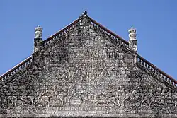
The main church in town, a Roman Catholic parish was constructed in 1859 and completed in 1869 by Spanish friar Tomas Santaren, of the Augustinian Order.[6] The church is unique among those in the Philippines for its large pediment featuring a military scene, the Spanish victory over the Moors in the Battle of Tetuan.[6][23] The National Museum of the Philippines listed the church as a National Cultural Treasure.[6][24]
San Joaquin Cemetery
.jpg)
The San Joaquin Cemetery is located along the main highway in San Joaquin Town. The construction of San Joaquin Cemetery was commenced by Fray Mariano Vamba, the last Augustinian parish priest of the town in 1892. A statue of Jesus with his arms outstretched stands on top of a baroque style gate, and on each side of Christ, two columns with angelic figures are poised as guards. In addition, sculpted heads of two cherubs and a skull representing death marks the entrance of the cemetery. Twenty stone steps after entering the gate and you will be greeted by the Baroque designed mortuary chapel standing on the center.[6]
Culture
The Bayluhay Festival, celebrated every third week of January, reflects the town's unique mixture of races and cultures. Historical and religious themes, mostly anchored from the Barter of Panay, such as efforts with the preservation of rituals, are reflected through the dances presented in the festivity. Accentuated every annual municipal fiesta is the “Pasungay” or bull fight. During this affair, the best bulls from the different barangays are pitted against each other by weight category in a “bull derby”.[6]
Tourism
The Talisayan Beach Resort is a privately owned beach resort located in the Poblacion. The Cata-an Cove and Tobog Beach Resort in Barangay Cata-an, about 10 kilometers from the Poblacion, is a place perfect for scuba diving and weekend outings. Garin Farm, a 15 hectare privately owned farm resort in Purok 2, Poblacion which showcases agriculture, leisure and pilgrimage theme. Practical and intelligent farming are imparted to the visitors through the agricultural techniques and innovative technologies applied in the demo farm. The resort leisure amenities include a swimming pool, a 5,000 sq.m man-made lagoon located on a hilltop, with fishes and lilies which offers fishing, boating and kayaking, and a 300 meters zip line which goes over the lagoon and through the trees. On the top of the hill sits the 101 Feet Divine Mercy Cross, which can be accessed by a 456 step stairway. Along the stairway are life-size and lifelike statues depicting the Creation, Noah's Ark, Ten Commandments, and the 9 Major Events of the Life of Jesus Christ.
Infrastructure
Healthcare
The San Joaquin Mother and Child Hospital (SJMCH), is a publicly managed, district-level hospital located in Barangay Baybay, San Joaquin, Iloilo. It operates 24 hours daily under the leadership of Dr. Rodel G. Gedalanga, MD, FPCP, who serves as Chief of Hospital I.[25]
It was inaugurated in April 2013 and initially operated under the supervision of the Western Visayas Medical Center (WVMC) and the municipal government. In 2019, Iloilo Governor Arthur Defensor Sr. signed Provincial Ordinance No. 2018‑191 converting SJMCH into the 13th district hospital under the Iloilo Provincial Government’s Hospital Management Office.[26]
The hospital is a primary-care facility with a 10‑bed capacity, serving maternal, neonatal, pediatric, and basic outpatient needs of residents in San Joaquin and neighboring municipalities.[27] [28] The provincial government allocated PHP 43 million in 2019 for its full integration into the district hospital network, covering operations, staffing, and equipment.[29]
In June 2023, the Iloilo Provincial Board passed a resolution urging the Department of Health to upgrade SJMCH’s license from a 10-bed infirmary to a 25-bed Level I General Hospital. This upgrade reflects the hospital’s expanded services, which now include an emergency room, clinical laboratory, imaging facilities, pharmacy, and an operating room.[27]
Additionally, in mid‑2024, a joint legislative committee confirmed that the land on which the hospital stands is government‑owned, ensuring uninterrupted operations and preventing any claims of donation revocation being enforced. [30]
In June 2025, a formal inter‑LGU partnership was approved between Iloilo Province and the Municipality of Anini-y, Antique to accept referrals for maternal and child health services at SJMCH, in line with Section 16 and Section 465 of Republic Act 7160, or the Local Government Code of 1991. [31]
Education
The town has 11 high schools.
- Don Felix Serra National High School (formerly San Joaquin High School)
- San Joaquin School of Fisheries
- Sta. Ana National High School
- Tiolas National High School
- Lawigan National High School
- Valverde National High School
- Escalantera National High School
- Sinogbuhan National High School
- Bad-as National High School
- Ginot-an National High School
- Pitogo National High School
References
- ^ Municipality of San Joaquin | (DILG)
- ^ "2015 Census of Population, Report No. 3 – Population, Land Area, and Population Density" (PDF). Philippine Statistics Authority. Quezon City, Philippines. August 2016. ISSN 0117-1453. Archived (PDF) from the original on May 25, 2021. Retrieved July 16, 2021.
- ^ "2024 Census of Population (POPCEN) Population Counts Declared Official by the President". Philippine Statistics Authority. July 17, 2025. Retrieved July 18, 2025.
- ^ "PSA Releases the 2021 City and Municipal Level Poverty Estimates". Philippine Statistics Authority. April 2, 2024. Retrieved April 28, 2024.
- ^ "2024 Census of Population (POPCEN) Population Counts Declared Official by the President". Philippine Statistics Authority. July 17, 2025. Retrieved July 18, 2025.
- ^ a b c d e f "San Joaquin". Garin Farm. Retrieved August 20, 2012.
- ^ "San Joaquin: Average Temperatures and Rainfall". Meteoblue. Retrieved May 3, 2020.
- ^ "Municipal: San Joaquin, Iloilo". PSGC Interactive. Quezon City, Philippines: Philippine Statistics Authority. Retrieved January 8, 2016.
- ^ Census of Population (2020). "Region VI (Western Visayas)". Total Population by Province, City, Municipality and Barangay. Philippine Statistics Authority. Retrieved July 8, 2021.
- ^ a b Census of Population and Housing (2010). "Region VI (Western Visayas)" (PDF). Total Population by Province, City, Municipality and Barangay. National Statistics Office. Retrieved June 29, 2016.
- ^ "2024 Census of Population (POPCEN) Population Counts Declared Official by the President". Philippine Statistics Authority. July 17, 2025. Retrieved July 18, 2025.
- ^ Census of Population (2015). "Region VI (Western Visayas)". Total Population by Province, City, Municipality and Barangay. Philippine Statistics Authority. Retrieved June 20, 2016.
- ^ Censuses of Population (1903–2007). "Region VI (Western Visayas)". Table 1. Population Enumerated in Various Censuses by Province/Highly Urbanized City: 1903 to 2007. National Statistics Office.
- ^ "Province of Iloilo". Municipality Population Data. Local Water Utilities Administration Research Division. Retrieved December 17, 2016.
- ^ "Poverty incidence (PI):". Philippine Statistics Authority. Retrieved December 28, 2020.
- ^ "Estimation of Local Poverty in the Philippines" (PDF). Philippine Statistics Authority. November 29, 2005.
- ^ "2003 City and Municipal Level Poverty Estimates" (PDF). Philippine Statistics Authority. March 23, 2009.
- ^ "City and Municipal Level Poverty Estimates; 2006 and 2009" (PDF). Philippine Statistics Authority. August 3, 2012.
- ^ "2012 Municipal and City Level Poverty Estimates" (PDF). Philippine Statistics Authority. May 31, 2016.
- ^ "Municipal and City Level Small Area Poverty Estimates; 2009, 2012 and 2015". Philippine Statistics Authority. July 10, 2019.
- ^ "PSA Releases the 2018 Municipal and City Level Poverty Estimates". Philippine Statistics Authority. December 15, 2021. Retrieved January 22, 2022.
- ^ "PSA Releases the 2021 City and Municipal Level Poverty Estimates". Philippine Statistics Authority. April 2, 2024. Retrieved April 28, 2024.
- ^ "San Joaquin Church: A Cultural Gem of the Philippines". exploreiloilo.com. Retrieved August 20, 2012.
- ^ Kenneth Acidera (June 25, 2017). "PeaceFul, tranquil, & serene: Going through history with reverence". aseavoy.weebly.com. Archived from the original on September 21, 2017. Retrieved June 10, 2023.
- ^ "Chiefs of Hospitals". Iloilo Provincial Government. Retrieved October 14, 2023.
- ^ "Iloilo guv approves add'l district hospital". Philippine News Agency. May 23, 2019. Retrieved July 28, 2025.
- ^ a b Momblan, Gail (May 23, 2019). "Iloilo guv approves add'l district hospital". Philippine News Agency. Retrieved July 28, 2025.
- ^ "San Joaquin's hospital gets P1.1-M aid". SunStar. November 4, 2013. Retrieved October 14, 2023.
- ^ "Iloilo guv approves add'l district hospital". Philippine News Agency. May 23, 2019. Retrieved July 28, 2025.
- ^ "SP presses ownership status quo amid dispute over San Joaquin hospital lot". Panay News. Retrieved October 14, 2023.
- ^ "Iloilo Province Extends Health Services to Anini‑y Residents Through San Joaquin Hospital". Iloilo Provincial Government. May 29, 2025. Retrieved July 27, 2025.
External links
- Philippine Standard Geographic Code
- Philippine Census Information
- San Joaquin on Local Governance Performance Management System Archived May 9, 2012, at the Wayback Machine
- . New International Encyclopedia. 1905.
Places adjacent to San Joaquin, Iloilo | |
|---|---|
Iloilo City (capital and largest city) | |
| Municipalities |
|
| Component city | |
| Highly urbanized city |
|