Sar Gol, Tehran
Sar Gol
Persian: سرگل | |
|---|---|
Village | |
 Sar Gol | |
| Coordinates: 35°22′49″N 51°40′07″E / 35.38028°N 51.66861°E[1] | |
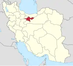
| Country | Iran |
| Province | Tehran |
| County | Pishva |
| District | Central |
| Rural District | Asgariyeh |
| Elevation | 967 m (3,173 ft) |
| Population (2016)[2] | |
• Total | 1,563 |
| Time zone | UTC+3:30 (IRST) |
Sar Gol (Persian: سرگل)[a] is a village in Asgariyeh Rural District[4] of the Central District in Pishva County, Tehran province, Iran.
Demographics
Population
At the time of the 2006 National Census, the village's population was 1,692 in 351 households, when it was in the former Pishva District of Varamin County.[5] The following census in 2011 counted 1,598 people in 404 households,[6] by which time the district had been separated from the county in the establishment of Pishva County. The rural district was transferred to the new Central District.[7] The 2016 census measured the population of the village as 1,563 people in 437 households.[2]
See also
Notes
References
- ^ OpenStreetMap contributors (31 July 2025). "Sar Gol, Asgariyeh RD, Pishva Central District, Pishva County, Tehran Province, Iran" (Map). OpenStreetMap (in Persian). Retrieved 31 July 2025.
- ^ a b سرشماري عمومي نفوس و مسكن 1395 : استان تهران [General Population and Housing Census 2016: Tehran Province]. مرکز آمار ایران [Statistical Centre of Iran] (in Persian). Archived from the original (Excel) on 12 December 2021. Retrieved 25 June 2025.
- ^ Sar Gol can be found at GEOnet Names Server, at this link, by opening the Advanced Search box, entering "-3877115" in the "Unique Feature Id" form, and clicking on "Search Database".
- ^ Habibi, Hassan (11 June 1995) [تاریخ تصویب (Approval date) 1374/03/21 (Iranian Jalali calendar)]. اصلاحات تقسیماتی در استان تهران [Divisional reforms in Tehran province]. لام تا کام [Lam ta Kam] (in Persian). وزارت کشور [Ministry of the Interior]. کمیسیون سیاسی دفاعی هیأت دولت [Political Defense Commission of the Government Board]. شناسه [ID] 5669DCDC-7F4C-4C6B-97F0-8BEE653F1C7A. شماره دوره [Course number] 74. Archived from the original on 26 December 2023. Retrieved 21 June 2025.
- ^ سرشماري عمومي نفوس و مسكن 1385 : استان تهران [General Population and Housing Census 2006: Tehran Province]. مرکز آمار ایران [Statistical Centre of Iran] (in Persian). Archived from the original (Excel) on 20 September 2011. Retrieved 22 June 2025.
- ^ سرشماري عمومي نفوس و مسكن 1390 : استان تهران [General Population and Housing Census 2011: Tehran Province]. Iran Data Portal—Syracuse University (in Persian). مرکز آمار ایران [Statistical Centre of Iran]. Archived from the original (Excel) on 20 January 2023. Retrieved 25 June 2025.
- ^ Rahimi, Mohammad Reza (27 November 2010) [6 آذر 1389 (Iranian Jalali calendar)]. با ايجاد 6 تغيير در جغرافياي استان تهران؛ شهرستان پیشوا به نقشه تقسیمات کشورى اضافه شد [With 6 changes in the geography of Tehran province; Pishva County was added to the map of national divisions]. Government of the Islamic Republic of Iran (in Persian). وزارت کشور [Ministry of the Interior]. هیات وزیران [Council of Ministers]. Archived from the original on 1 August 2018. Retrieved 24 June 2025.
| Capital | |||||||||||||||||||||
|---|---|---|---|---|---|---|---|---|---|---|---|---|---|---|---|---|---|---|---|---|---|
| Districts |
| ||||||||||||||||||||