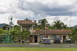
Semporna Airport
Semporna Airport Lapangan Terbang Semporna | |||||||||||
|---|---|---|---|---|---|---|---|---|---|---|---|
 | |||||||||||
| Summary | |||||||||||
| Airport type | Public | ||||||||||
| Operator | Malaysia Airports Berhad | ||||||||||
| Serves | Semporna, Sabah, Malaysia | ||||||||||
| Time zone | MST (UTC+08:00) | ||||||||||
| Elevation AMSL | 60 ft / 18 m | ||||||||||
| Coordinates | 04°26′59″N 118°35′47″E / 4.44972°N 118.59639°E | ||||||||||
| Map | |||||||||||
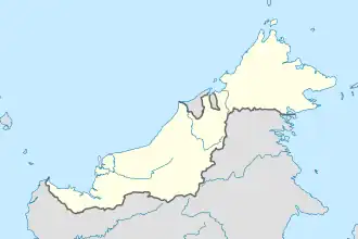 WBKA Location in East Malaysia | |||||||||||
| Runways | |||||||||||
| |||||||||||
Semporna Airport (IATA: SMM[2], ICAO: WBKA) is an airport serving the town of Semporna in the east Malaysian state of Sabah. At present, the airport is not served by any commercial civilian flights.
See also
References
- ^ AIP Malaysia: Index to Aerodromes at Department of Civil Aviation Malaysia
- ^ Airport information for SMM at Great Circle Mapper.
External links
Wikimedia Commons has media related to Semporna Airport.
- Short Take-Off and Landing Airports (STOL) at Malaysia Airports Holdings Berhad
- Accident history for SMM at Aviation Safety Network