Severin Sterm
Nicolai Severin Sterm (1784 - 24 November 1853) was a Danish topographical writer.
Biography
Sterm was born in 1784 to Peter Severin Sterm (ca. 1732–1800) and Anne Marie Bjørn (ca. 1753– 1816). His father owned Vejen Watermill. He later bought Hanne-vanggård at Vejle.[1]
Written works
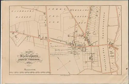
Sterm worked on a comprehensive topographical work about Denmark and Slesvig-Holsten-Lauenburg. The first volume was published in 1831 as Topographie over Frederiksborg Amt. It was later followed by Statistisk-topographisk Beskrivelse over Kjøbenhavns Amt, Vol. I–III (1834–38). It was published with economic support from the politician Carl Simony. His nexct publication was Statistisk-topographisk Beskrivelse over Hoved- og Residentsstaden Kjøbenhavn, Vol 1O-OOO (1839–41).[1] Other publications include a series of maps of the districts of Copenhagen from 1830–1841.[2]
References
- ^ a b "Peter C. Schiønning". Dansk Biografisk Leksikon (in Danish). Retrieved 16 June 2022.
- ^ "Sag: Dansepavillon" (in Danish). Kulturstyrelsen. Retrieved 15 September 2019.
External links
- Images in the National Library of Denmark