Valle Antrona
| Valle Antrona | |
|---|---|
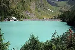
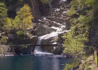 The Troncone River flowing into Lake Antrona | |
| Area | 141.43 km2 (54.61 sq mi) |
| Geography | |
| Country | Italy |
| State | Piemonte |
| comune | Verbano-Cusio-Ossola |
| Population centers | Montescheno, Borgomezzavalle, Antrona Schieranco |
| River | Ovesca |
| Website | |
Valle Antrona (Antrona Valley) is a valley of the Alps, situated in the Pennine range. The valley is drained by the Ovesca, a tributary meeting the Toce at Villadossola, one of the seven valleys of the Val d'Ossola. It has a total of 1,140 inhabitants, distributed over an area of 141.43 km². Sporting the Alta Valle Antrona Natural Park, it is situated to the north of the Valle Anzasca. Historically it was the site of gold and mica mining. Its demonym is "Antronesi".
Geography
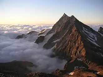
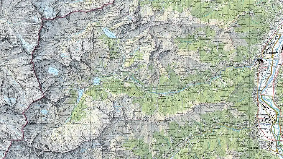
The Antrona Valley is surrounded by mountains on its north, south and west sides. The minimum altitude of valley bottom is 450 m above sea level. Road access is via its opening in the east in Montescheno comune, following the route of the Ovesca River. The Pizzo d'Andolla at 3,656m is the highest mountain in the valley, forming part of the Swiss-Italian border. The valley encompasses the comunes of Antrona Schieranco and Saas-Almagell in the west and Borgomezzavalle and Villadossola in the east.
The Alta Valle Antrona Natural Park is located within the valley.[1]
Mountains
The valley is situated in the Pennine Alps, more specifically, in the Andolla range.
The main mountains surrounding the valley are:
- Pizzo d'Andolla - 3,656 m
- Pizzo Bottarello or Sonnighorn - 3,487 m
- Pizzo Loranco or Mittelruk - 3,362 m
- Pizzo Scarone - 3,341 m
- Jazzihorn or Pizzo Cingino Nord - 3,226 m
- Punta di Saas or Latelhorn - 3,200 m
- Punta Laugera - 2,995 m
- Punta della Rossa - 2,911 m
- Punta Turiggia - 2,811 m
- Pizzo San Martino - 2,733 m
- Pizzo Montalto - 2,705 m
- Pizzo del Ton - 2,675 m
- Pizzo Ciapè - 2,394 m
Passes
- Antrona Pass or Saas Pass (2,839 m) - towards the Swiss Saastal valley.
- Cingino Pass or Jazziluke (3,080 m) - towards the Swiss Ofental Valley.
- Antigine Pass or Ofental Pass (2,833 m) - towards the Swiss Ofental Valley.
Hydrography
Water in the Antrona Valley is a significant resource; streams and lakes abound. The Ovesca river, from its headwaters at Lake Antrona, runs the entire course of the valley. Lake Antrona was formed naturally following a landslide in 1642; its main tributary is the Troncone from the Pizzo d'Antigine. Shortly before flowing into Lake Antrona, the waters of the Troncone are dammed, creating the artificial Lake Campliccioli and used for hydroelectric power. Another artificial lake is Lake Cingino, located at 2,262 m above sea level. It is famous for its Alpine Ibex, who ascend the nearly vertical wall of the dam to lick salts (saltpeter).[2]

In addition to the Troncone, Lake Campliccioli is also fed by the outlet of Lake Camposecco, also used for hydroelectric power. After passing the Campliccioli Dam, the Troncone quickly descends to Lake Antrona and ultimately to its outlet at the Ovesca River.[3]
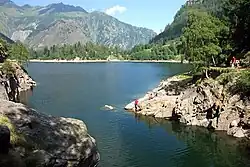
The Ovesca then reaches Antronapiana and receives one of its largest tributaries from the north: the Loranco. The stream rises at the foot of Pizzo d'Andolla and near Alpe Cheggio is dammed to form Lake Alpe dei Cavalli (or Lake Cheggio); the largest body of water in the Antrona Valley and also used for hydroelectric power. After passing the dam, the Loranco flows through the pastures of Alpe Cheggio and Alpe di Campo, finally reaching Antronapiana. After receiving the Loranco, the Ovesca continues down the valley, receiving various tributaloreries from both sides. Downstream from Montescheno, it receives its largest tributary: the Brevettola River, which rises on the slopes of Pizzo San Martino and then flows past the hamlets of Montescheno.[3]
The Ovesca River then leaves the Antrona Valley and descends into the Ossola Valley, where it flows into the Toce River after passing through Villadossola.
Climate
The Antrona Valley has a typically Alpine climate with long, harsh, snowy winters and cool, rainy summers. Precipitation is frequent and the valley sports one of the highest average annual rainfall in Italy. Rainfall is more frequent in autumn, especially in October, often causing serious problems such as flooding and landslides. Snow covers the valley's main peaks for long periods and in the coldest months it also falls to the valley floor. The highest peaks also feature some small glaciers. In winter the valley bottoms are often covered by a thick layer of ice that only melts in late spring.
Monuments and Places of Interest
The entrance to the Antrona Valley is located in Villadossola but the valley itself begins in the Montescheno comune. This municipality is a cluster of hamlets nestled among orchards, pastures, and chestnut groves. The first town you come across is Cresti, the seat of the municipality, which also houses the Parish Church of Saints John the Baptist and Charles. From Cresti, a secondary road leads to Sasso, Barbuniga, Vallemiola, Valleggia, and Zonca. Vallemiola enjoys a sunny position and houses the Oratory of the Madonna delle Grazie and two large ancient wine presses. One of the presses has recently been restored. In Valleggia, there is an ancient wine press and a typical hamlet's bread oven. Barbuniga also has a press, still in excellent condition, built in 1745 and no longer in use since 1980. Barbuniga also features a traditional bread oven, and before World War II, there was also a large hamlet still for the production of grappa, of which no trace remains today. The hamlet of Zonca can only be reached on foot, and it houses two presses and two hamlet ovens.
After passing Montescheno, you enter the former municipality of Seppiana (now part of the new Borgomezzavalle comune), which was once the only parish church in the entire valley. In the center of the village stands the ancient 11th-century parish church of Saint Ambrose. The center of Seppiana also features a couple of ancient buildings with frescoes and an arched portal. In the locality of Le Selve, there is a 12th-century crucifix, while in the locality of San Rocco, there is a 17th-century oratory.
The next town after Seppiana is Viganella (also part of Borgomezzavalle), home to the former Valle Antrona Mountain Community. Given Viganella's limited sunlight (during the winter months), a project was developed to install a 40-square-meter mirror on the mountain opposite the town (about 870 meters away and 480 meters above sea level). This reflects the sun onto the town square, providing light for several hours a day. The centre of Viganella is home to the 16th-century parish church of the Nativity of the Virgin Mary and several ancient buildings of interesting architecture. Numerous chapels and oratories are found throughout the municipality, among which the 17th-century buildings of San Domenico and San Giulio stand out.
After passing Viganella, one enters Antrona Schieranco, another comune consisting of a cluster of hamlets and villages: San Pietro, Prabernardo (Inferiore and Superiore), Schieranco, Madonna, Locasca, Rovesca, Antronapiana, Antrona Lago, Cheggio, Ronco, Arvina, and Cimallegra.
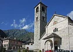
After passing San Pietro, with its eponymous church, one reaches Prabernardo, where a turnoff leads to Schieranco. Continuing along the main road, one comes across Madonna, with its 16th-century Church of the Blessed Virgin of Mount Carmel; Locasca, with the 17th-century Church of San Francesco and the Madonna della Neve; and Rovesca, with the 16th-century Oratory of San Gottardo. After passing these hamlets, one reaches Antronapiana, seat of the municipality of Antrona Schieranco and the capital of the Antrona Valley. In this hamlet are the 13th-century parish church of San Lorenzo and the 17th-century oratories of Saint Anna and the Beata Vergine della Neve. From Antronapiana, you can climb to Cheggio, home to the 17th-century Oratory of San Bernardo. In winter skiing is possible via a ski lift.
Economy
Tourism is the basis of the valley's economy with the greatest employment opportunities found in the valley floor in the municipality of Villadossola. Mining played a major role in the past: from 1736 to 1936, gold mines operated in the Antrona Schieranco comune, and mica mines from 1922 to 1960. Evidence of the former woodworking industry also remains. The early 20th century saw the beginning of the exploitation of the catchment areas and reservoirs (both artificial and natural) for hydroelectric power are still active, including Lake Antrona.
Demographics
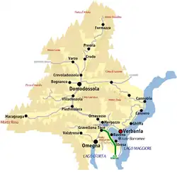
The valley is located in the Province of Verbano-Cusio-Ossola, in the Piedmont region of Italy. It is politically divided into three municipalities: Antrona Schieranco, Montescheno and Borgomezzavalle.
The table gives figures for the three municipalities that form part of the Antrona Valley (as of 30 November 2021):[4]
| Coat of Arms | Comune | Population
(Inhabitants) |
Area
(km²) |
Density
(people/km²) |
Altitude
(m above s.l.) |
Lowest Altitude
(m above s.l.) |
Maximum Altitude
(m above s.l.) |
|---|---|---|---|---|---|---|---|
| Antrona Schieranco | 402 | 100.18 | 4.01 | 902 | 590 | 3513 | |
| Montescheno | 383 | 22.17 | 17.3 | 512 | 372 | 2399 | |
| Borgomezzavalle | 293 | 19,.08 | 15.4 | 582 | 389 | 2261 | |
| Total | – | 1078 | 141.43 | 7.6 | - | 372 | 3513 |
List of Settlements
Frazione in the Villadossoloa comune:
- Boschetto
- Cresti
In the Borgomezzavalle comune:
In the Antrona Schieranco comune:
- San Pietro
- Schieranco
- Antronapiana
Maps
See also
References
- ^ "Antrona Valley". Visit Ossola. Retrieved 5 May 2025.
- ^ Andrei, Mihai (2024-12-26). "These God dammed goats will make you question what you know about gravity". ZME Science. Retrieved 2025-07-20.
- ^ a b "Valle Antrona - i nostri laghi". Valle Antrona. Retrieved 5 May 2025.
- ^ "Bilancio demografico mensile". demo.istat.it. Retrieved 2025-07-20.
46°02′44″N 8°10′26″E / 46.04556°N 8.17389°E