Zumarraga, Samar
Zumarraga | |
|---|---|
| Municipality of Zumarraga | |
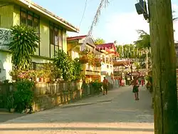 Downtown area | |
 Flag | |
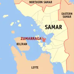 Map of Samar with Zumarraga highlighted | |
OpenStreetMap | |
.svg.png) Zumarraga Location within the Philippines | |
| Coordinates: 11°38′20″N 124°50′28″E / 11.639°N 124.841°E | |
| Country | Philippines |
| Region | Eastern Visayas |
| Province | Samar |
| District | 2nd district |
| Named after | Zumarraga, Spain |
| Barangays | 25 (see Barangays) |
| Government | |
| • Type | Sangguniang Bayan |
| • Mayor | Myrna O. Tan |
| • Vice Mayor | Analyn M. Ojeda |
| • Representative | Reynolds Michael Tan |
| • Electorate | 13,509 voters (2025) |
| Area | |
• Total | 38.55 km2 (14.88 sq mi) |
| Elevation | 17 m (56 ft) |
| Highest elevation | 348 m (1,142 ft) |
| Lowest elevation | 0 m (0 ft) |
| Population (2024 census)[3] | |
• Total | 16,051 |
| • Density | 420/km2 (1,100/sq mi) |
| • Households | 3,606 |
| Demonym | Zumaragahnon |
| Economy | |
| • Income class | 5th municipal income class |
| • Poverty incidence | 34.28 |
| • Revenue | ₱ 107.6 million (2022) |
| • Assets | ₱ 171.3 million (2022) |
| • Expenditure | ₱ 809.4 million (2022) |
| • Liabilities | ₱ 34.04 million (2022) |
| Service provider | |
| • Electricity | Samar 2 Electric Cooperative (SAMELCO 2) |
| Time zone | UTC+8 (PST) |
| ZIP code | 6725 |
| PSGC | |
| IDD : area code | +63 (0)55 |
| Native languages | Waray Tagalog |
| Patron saint | Anthony of Padua |
Zumarraga, officially the Municipality of Zumarraga (Waray: Bungto han Zumarraga; Tagalog: Bayan ng Zumarraga), is an island municipality in the province of Samar , Philippines. According to the 2020 census, it has a population of 16,279 people.[5]
It is formerly known as Buad, Rawis, and Kawayan. The town itself, notably its downtown area, is considered by many heritage scholars as a heritage zone due to the many heritage houses within its vicinity. The local government unit is currently conserving the history and traditions of the town.
The town is also famous for two alcoholic beverages: kinutil (tubâ or coconut wine with egg yolk) and dubado (tubâ with melted tablea).[6]
History

The town of Zumarraga was known for years due its flourishing fishing industry. This began with a small fishing village of families who had sailed from Leyte. They discovered the island on a routine fishing trip, and sought safe harbour from a storm in the area now called Rawes. They found the place ideal for settlement, naturally pleasing due to the presence of bamboo, hence calling it “Kawayan” upon their return to.
These village became prosperous due to an abundance of fish in the surrounding waters, drawing people from neighbouring areas for business. The first to come were the Ferreras from Leyte.
News of this rich fishing village reached the Moro pirates so they extended their raids to Visayan waters. To keep themselves safe, natives built strong stone fortifications atop the hill overlooking the town, which are preserved by the people’s descendants.
The exact date of the Spanish arriving in Zumarraga is uncertain, but the earliest record is from 1848, when a Spanish friar was sent to the settlement. It was said how upon their coming, the Spaniards already found the natives under the laws of the autonomous body ruling the village. The name of the place was already "Buad", from the local term "Binuwaaran" (the digging made by wild pigs). The village was finally renamed “Zumarraga”, as the first Spanish curate, Rev. Fr. Martin Yepes, was born in Zumarraga, in the Basque Country of Spain.
On March 13, 1863, the town became an independent parroquia by virtue of royal decree of Queen Isabella II. On Oct. 12, 1865, it was confirmed the town was a parish under a certain diocese. The parish priest thus had jurisdiction over the islands of Buad and Daram, including Paranas.
With the coming of Spanish clergy came educational, spiritual and moral improvement for the locals. This attracted immigrant families from neighbouring towns, islands, and provinces, foremost being the Zetas from Palo, Leyte; the Astorgas from Barugo, Leyte; the Villaflors from Carigara, Leyte; the Dazas, Magas, and Narios from Catbalogan, Samar; as well as the Carcellars, Zosas, Versosas and Castillos.
A well-organised local government was established, its chief executive titled Capitán. The early capitanes, in the order of succession, were: Tenorio Ferrer (Capitán Toyang), Nepomuceno Zeta (Capitán Sinoy), Nicolás Custodio (Capitán Colas), Salvador Zeta (Capitán Badoy), Brígido Heal (Capitan Bido), Tomás Bello, Hilario Villaflor and Agustín Astorga. These officials were appointed by the Gobernadorcillo upon advice of the parish priest, who also served as the local Inspector. Much had happened during the Spanish era but no written records exist, and townsfolk rely on oral histories passed down through families.
When the United States took possession of the Philippines with a military government following the Spanish-American War, change also came on the local level. Free elections were introduced, and the local town executive was retitled Presidente. The presidentes, in the order of tenure, were: Mario Maga, 1910; Luis Villaflor, 1911; Lucio Mijares, 1913; Leodergario Carcellar, 1914; Enrique Nario, 1916; Benito Astorga, 1920; Enrique Nario, 1926; and Rodrigo Daza, 1931.
Population growth came mainly by immigration from neighboring places, driving an increase in industry and business, particularly in fishing. It was during this rapid development that the wharf and part of the breakwater were built. The most illustrious son of Zumarraga, the late Pedro R. Arteche, was the local delegate to the 1934 Philippine Constitutional Convention election; he subsequently occupied the gubernatorial seat for the provinces of Samar. During this period, the elected town executive was known as Mayor. Until the outbreak of the Second World War, these were: 1936-1938 Mayor Emilio Zeta, Vice-Mayor Leodegario Carcellar; 1939-Mayor Francisco Zosa, Vice Mayor Francisco Castillo.
The town was damaged in the war but the local government tried its best to reconstruct and improve public works. These include cementing streets, the establishment of the Puericculture Center, putting up electric lighting, a public market, and the construction of additional pre-fab, Marcos-Era and the Bagong Lipunan buildings. A private Catholic high school was established by few civic-spirited citizens, and duly recognised by the government, still serving Zumarraga and surrounding areas.
The town’s centuries-old Catholic church is dedicated to its patron, Saint Anthony of Padua, and is now being reconstructed. Such project has been attributed to different priests, the Parish Council and the generosity of Zumaraganhons now residing in Manila, Cebu City, Iligan City, Tacloban City, Catbalogan, and Calbayog who have prospered in their own lines of profession and industry and through the collective efforts of all Zumaraganhons.
Geography
Barangays
Zumarraga is divided into 25 barangays. Each barangay consists of puroks and some have sitios.
- Alegria
- Arado
- Arteche
- Bioso
- Boblaran
- Botaera
- Buntay
- Camayse
- Canwarak
- Ibarra
- Lumalantang
- Macalunod
- Maga-an
- Maputi
- Monbon
- Mualbual
- Pangdan
- Poro
- San Isidro
- Sugod
- Tinaugan
- Tubigan
- Poblacion 1 (Barangay 1)
- Poblacion 2 (Barangay 2)
- Marapilit
- Talib
- Igpit opol
Climate
| Climate data for Zumarraga, Samar | |||||||||||||
|---|---|---|---|---|---|---|---|---|---|---|---|---|---|
| Month | Jan | Feb | Mar | Apr | May | Jun | Jul | Aug | Sep | Oct | Nov | Dec | Year |
| Mean daily maximum °C (°F) | 27 (81) |
28 (82) |
28 (82) |
30 (86) |
30 (86) |
30 (86) |
29 (84) |
29 (84) |
29 (84) |
29 (84) |
28 (82) |
28 (82) |
29 (84) |
| Mean daily minimum °C (°F) | 22 (72) |
22 (72) |
22 (72) |
23 (73) |
24 (75) |
24 (75) |
24 (75) |
24 (75) |
24 (75) |
24 (75) |
23 (73) |
23 (73) |
23 (74) |
| Average precipitation mm (inches) | 114 (4.5) |
81 (3.2) |
94 (3.7) |
81 (3.2) |
119 (4.7) |
192 (7.6) |
186 (7.3) |
158 (6.2) |
167 (6.6) |
185 (7.3) |
202 (8.0) |
176 (6.9) |
1,755 (69.2) |
| Average rainy days | 18.6 | 14.7 | 16.8 | 17.8 | 22.3 | 25.9 | 27.5 | 26.2 | 26.6 | 27.0 | 24.6 | 22.3 | 270.3 |
| Source: Meteoblue[7] | |||||||||||||
Demographics
| Year | Pop. | ±% p.a. |
|---|---|---|
| 1903 | 9,992 | — |
| 1918 | 11,068 | +0.68% |
| 1939 | 21,225 | +3.15% |
| 1948 | 30,593 | +4.15% |
| 1960 | 11,549 | −7.80% |
| 1970 | 12,064 | +0.44% |
| 1975 | 13,297 | +1.97% |
| 1980 | 12,821 | −0.73% |
| 1990 | 13,324 | +0.39% |
| 1995 | 14,505 | +1.60% |
| 2000 | 15,423 | +1.32% |
| 2007 | 16,743 | +1.14% |
| 2010 | 16,936 | +0.42% |
| 2015 | 16,295 | −0.73% |
| 2020 | 16,279 | −0.02% |
| 2024 | 16,051 | −0.34% |
| Source: Philippine Statistics Authority [8][9][10][11] | ||
Economy
Poverty incidence of Zumarraga
10
20
30
40
50
60
70
80
90
2000
68.60 2003
80.11 2006
46.10 2009
49.86 2012
49.53 2015
49.90 2018
38.87 2021
34.28 Source: Philippine Statistics Authority[12][13][14][15][16][17][18][19] |
References
- ^ Municipality of Zumarraga | (DILG)
- ^ "2015 Census of Population, Report No. 3 – Population, Land Area, and Population Density" (PDF). Philippine Statistics Authority. Quezon City, Philippines. August 2016. ISSN 0117-1453. Archived (PDF) from the original on May 25, 2021. Retrieved July 16, 2021.
- ^ "2024 Census of Population (POPCEN) Population Counts Declared Official by the President". Philippine Statistics Authority. 17 July 2025. Retrieved 18 July 2025.
- ^ "PSA Releases the 2021 City and Municipal Level Poverty Estimates". Philippine Statistics Authority. 2 April 2024. Retrieved 28 April 2024.
- ^ "2024 Census of Population (POPCEN) Population Counts Declared Official by the President". Philippine Statistics Authority. 17 July 2025. Retrieved 18 July 2025.
- ^ Kapuso Mo, Jessica Soho: Comfort food ng mga Waray. YouTube. Archived from the original on 2021-12-11.
- ^ "Zumarraga: Average Temperatures and Rainfall". Meteoblue. Retrieved 29 February 2020.
- ^ Census of Population (2015). "Region VIII (Eastern Visayas)". Total Population by Province, City, Municipality and Barangay. Philippine Statistics Authority. Retrieved 20 June 2016.
- ^ Census of Population and Housing (2010). "Region VIII (Eastern Visayas)" (PDF). Total Population by Province, City, Municipality and Barangay. National Statistics Office. Retrieved 29 June 2016.
- ^ Censuses of Population (1903–2007). "Region VIII (Eastern Visayas)". Table 1. Population Enumerated in Various Censuses by Province/Highly Urbanized City: 1903 to 2007. National Statistics Office.
- ^ "Province of". Municipality Population Data. Local Water Utilities Administration Research Division. Retrieved 17 December 2016.
- ^ "Poverty incidence (PI):". Philippine Statistics Authority. Retrieved December 28, 2020.
- ^ "Estimation of Local Poverty in the Philippines" (PDF). Philippine Statistics Authority. 29 November 2005.
- ^ "2003 City and Municipal Level Poverty Estimates" (PDF). Philippine Statistics Authority. 23 March 2009.
- ^ "City and Municipal Level Poverty Estimates; 2006 and 2009" (PDF). Philippine Statistics Authority. 3 August 2012.
- ^ "2012 Municipal and City Level Poverty Estimates" (PDF). Philippine Statistics Authority. 31 May 2016.
- ^ "Municipal and City Level Small Area Poverty Estimates; 2009, 2012 and 2015". Philippine Statistics Authority. 10 July 2019.
- ^ "PSA Releases the 2018 Municipal and City Level Poverty Estimates". Philippine Statistics Authority. 15 December 2021. Retrieved 22 January 2022.
- ^ "PSA Releases the 2021 City and Municipal Level Poverty Estimates". Philippine Statistics Authority. 2 April 2024. Retrieved 28 April 2024.
External links
- Zumarraga Profile at PhilAtlas.com
- Philippine Standard Geographic Code
- Philippine Census Information
- Local Governance Performance Management System Archived 2016-03-04 at the Wayback Machine
Places adjacent to Zumarraga, Samar | ||||||||||||||||
|---|---|---|---|---|---|---|---|---|---|---|---|---|---|---|---|---|
| ||||||||||||||||
| Municipalities | |
|---|---|
| Component cities | |