Pocklington Reef
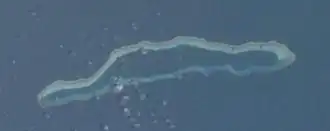 ISS image of Pocklington Reef | |
 Pocklington Reef | |
| Geography | |
|---|---|
| Location | Solomon Sea |
| Coordinates | 10°48′44″S 155°44′18″E / 10.81222°S 155.73833°E[1] |
| Type | Reef |
| Archipelago | Louisiade Archipelago |
| Adjacent to | Solomon Sea |
| Total islands | 2 inhabited on Bentley Group |
| Major islands |
|
| Area | 0.01 km2 (0.0039 sq mi) |
| Highest elevation | 1 m (3 ft) |
| Administration | |
| Province | Milne Bay |
| District | Samarai-Murua District |
| LLG | Yaleyamba Rural Local Level Government Area |
| Demographics | |
| Population | 0 (2014) |
| Pop. density | 0/km2 (0/sq mi) |
| Additional information | |
| Time zone | |
| ISO code | PG-MBA |
| Official website | www |
Pocklington Reef is a coral reef and a mostly submerged atoll in the far southeast of Papua New Guinea.
It is 162.4 km (100.9 mi) from the closest island, Loa Boloba, which is a tiny coral islet within the fringing reef near Cape Deliverance, the south east point of Rossel Island (Yela) in the Louisiade Archipelago, and belongs to Milne Bay province, Samarai-Murua District, Yaleyamba Rural Local Level Government Area.
Pocklington Reef sits on top of Pocklington Ridge, which extends north-east from Rossel Island. The reef is 32 km (20 mi) long and up to 4 km (2.5 mi) wide. Its longer axis is north-east-south-west. The rim of the reef encloses a deep lagoon. The northern rim reaches closer to the surface, and several above water rocks with heights between 0.9 and 3 m (2 ft 11 in and 9 ft 10 in) high lie along its length. There is a small spit of sand about the size of a football field (less than one hectare or 2.5 acres) at the north-east end.
It is isolated from other reef systems by deep water and relatively pristine.
Before Papua New Guinea achieved sovereignty in 1975 it was decided Pocklington Reef should be part of the new nation.[2]
History
The reef was discovered and named by the captain of the Sydney whaler Pocklington in 1825.[3]
HMS Renard under the command of Lieutenant G.E. Richards surveyed the reef in 1880 and noted there was no anchorage around its perimeter.[4]
On 28 April 1962, the Panamanian vessel SS Dona Ourania (8,716 tons)[5] grounded on Pocklington Reef.[6]
In April 1974 the soviet vessel Fedor Litke spent a week at a sandbank on the reef. An Australian naval vessel visited the site soon after and it was reported a concealed electronic monitoring device was found there.[7]
Illegal drugs worth $30 million were hidden in a wreck on the reef in 1978. Stored in watertight bags, the cannabis had been left by a trawler from Thailand.[8]
Shipwrecks
A number of vessels have been wrecked on the atoll.[9]
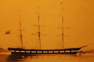
At midnight on the 26th September 1855 the Clipper ship Brig Reindeer was lost upon Pocklington Reef. The captain Edward Storey reported it as there had been a moderate, breeze and hazy, when at 11:30pm the look out on the forecastle reported breakers on the lee bow. The vessel was put hard to the port, but the vessel struck hard on the reef and filled immediately to the level of the water outside. The masts were cut away but the mizen hit two of the boats on the deck. The ships 20 ft long boat was got away with navigation instruments, 17 gallons of water, ships papers and some arms and was pulled through the surf zone. The following morning at daylight the crew saw the small grouping of rocks about 8 miles to the north. They set up a tent from oars and sails and set about removing more materials from the Reindeer. The crew remained on the small outcrop for 9 days and departed on the 6th of October at 8:30am with all 19 crew (among the crewmen aboard was Walter Powell) by 4pm they had cleared the Western end of the reef having run at 5 knots for 7.5hrs.[10]
After being at sea for 42 days they reached Port Curtis on the 16th of November [10] The Reindeer was a wooden sailing vessel built by Alexander Hall & Co, Aberdeen in 1848 in yard number 168 and was 328 nrt and a length of 141.5 ft with a breath of 22.7 ft and a depth of 21.5 ft and had been built for McTear & Vining. Of Liverpool [11] before being sold onto Jervis R. Wardley
In 1850 the Reindeer made the fastest Tea run of 107 days [12]
The Earl of Hardwick (280 tons) was on the way from Newcastle, New South Wales, with a cargo of coal to Hong Kong in 1862 when it was wrecked on 10 June.[13][14]
The Genevieve (1,000 tons) was a relatively new vessel built at Quebec in 1870 and sailing from Melbourne to Manilla when she came to grief in September 1874.[15] Captain Largie, of the Woodlark, ship, bound from Brisbane to Hong Kong: reported sighted a vessel ashore at the south-west end of the Pocklington Reef. She had nothing standing but the mizzen mast and bowsprit, and evidently had been on the reef some time [16]
The Japanese ship Amigi Maru (280 ft (85 m),[17] 2,249 tons) ran aground during a cyclone in May 1972.[18] It could not be saved and had to be abandoned.[19]
Fishing
A Taiwanese fishing vessel was detected illegally fishing off the reef in October 1979 within PNG’s 200-nautical-mile (370 km; 230 mi) fishing zone. The skipper was fined 1000 kina and the vessel’s fishing gear was seized.[20]
Sports fishing takes place off Pocklington Reef.[21]
Marine protected area
Pocklington Reef Marine Park is a proposed marine protected area.[1]
References
- ^ a b Pocklington Reef Wood, L. J. (2007). MPA Global: A database of the world's marine protected areas. Sea Around Us Project, UNEP-WCMC & WWF. www.mpaglobal.org
- ^ Papua New Guinea Post-Courier, 18 September 1974, p.2
- ^ Nicholson, Ian (1981). Gazetteer of Sydney shipping, 1788-1840 (First ed.). Canberra: Roebuck. p. 144. ISBN 0909434182.
- ^ Pacific Islands pilot, with supplements and Admiralty notices to mariners. London: Admiralty Hydrographic Department. 1885. p. 54.
- ^ Dona Ourania Wear Built Ships
- ^ Gerald Forsberg Salvage from the Sea Publisher: Routledge and Kegan Paul, Jan 1, 1977
- ^ Canberra Times, 23 April 1975, p.1
- ^ Canberra Times, 17 June 1978, p.1
- ^ Catalog of Nautical Charts.
- ^ a b "LOSS OF THE REINDEER". The Shipping Gazette And Sydney General Trade List. Vol. XIII, no. 610. New South Wales, Australia. 14 January 1856. p. 7. Retrieved 17 August 2025 – via National Library of Australia.
- ^ https://www.clydeships.co.uk/view.php?official_number=&imo=&builder=&builder_eng=&year_built=&launch_after=&launch_before=&role=&type_ref1=&propulsion=&owner=&port=&flag=&disposal=&lost=&ref=57595&vessel=REINDEER
- ^ https://emuseum.aberdeencity.gov.uk/objects/100089/reindeer
- ^ Loney, Jack (1980). Australian shipwrecks, Vol 2: 1851-1871 (First ed.). Sydney: Reed. p. 133. ISBN 0589501003.
- ^ Sydney Morning Herald, 28 November 1862, p.4
- ^ Northern Argus (Rockhampton, Queensland), 22 September 1874, p.2
- ^ "(From the Courier.)". Maryborough Chronicle, Wide Bay and Burnett Advertiser. No. 1997. Queensland, Australia. 7 June 1877. p. 2. Retrieved 16 October 2022 – via National Library of Australia.
- ^ "Distress call by ship". Papua New Guinea Post-courier. International, Australia. 30 May 1972. p. 4. Retrieved 16 October 2022 – via National Library of Australia.
- ^ Papua New Guinea Post-Courier, 30 May 1972, p.4
- ^ Papua New Guinea Post-Courier, 1 June 1972, p.1
- ^ Papua New Guinea Post-Courier, 23 October 1979, p.3
- ^ “Giant Pelagics in Pocklington Reef Expedition!”, accessed 20 April 2021
External links
- Satellite image at the Wayback Machine (archived December 23, 2010)
- Maritime boundaries
- Papua New Guinea Act
Islands of Papua New Guinea | |
|---|---|
| Bismarck Archipelago | |
| Louisiade Archipelago | |
| North Solomon Islands | |