Portal:New Guinea
The New Guinea Portal
Introduction
Native name: Papua, Niugini, Niu Gini | |
|---|---|
 | |
| Geography | |
| Location | Oceania (Melanesia) |
| Archipelago | Melanesia and Malay Archipelago |
| Area | 785,753 km2 (303,381 sq mi) |
| Area rank | 2nd |
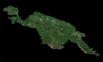
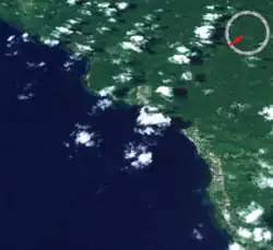
New Guinea (Tok Pisin: Niugini; Hiri Motu: Niu Gini; Indonesian: Papua, fossilized Nugini, also known as Papua or historically Irian) is the world's second-largest island, with an area of 785,753 km2 (303,381 sq mi). Located in Melanesia in the southwestern Pacific Ocean, the island is separated from Australia by the 150-kilometre (81-nautical-mile; 93-mile) wide Torres Strait, though both landmasses lie on the same continental shelf, and were united during episodes of low sea level in the Pleistocene glaciations as the combined landmass of Sahul. Numerous smaller islands are located to the west and east. The island's name was given by Spanish explorer Yñigo Ortiz de Retez during his maritime expedition of 1545 due to the perceived resemblance of the indigenous peoples of the island to those in the African region of Guinea. (Full article...)
Papua New Guinea (PNG), officially the Independent State of Papua New Guinea, is an island country in Oceania that comprises the eastern half of the island of New Guinea and offshore islands in Melanesia, a region of the southwestern Pacific Ocean north of Australia. It has a land border with Indonesia to the west and maritime borders with Australia to the south and the Solomon Islands to the east. Its capital is Port Moresby. The country's 462,840 km2 (178,700 sq mi) includes a large mainland and hundreds of islands. (Full article...)
Western New Guinea, also known as Papua, Indonesian New Guinea, and Indonesian Papua, is the western half of the island of New Guinea, formerly Dutch and granted to Indonesia in 1962. Given the island is alternatively named Papua, the region is also called West Papua (Indonesian: Papua Barat). It is one of the seven geographical units of Indonesia in ISO 3166-2:ID. (Full article...)
Selected article -
-


The Ok Tedi Mine
The Ok Tedi Mine is an open-pit copper and gold mine in Papua New Guinea located near the headwaters of the Ok Tedi River, in the Star Mountains Rural LLG of the North Fly District of the Western Province of Papua New Guinea.
The mine is operated by Ok Tedi Mining (OTM), which is majority-owned by the PNG Sustainable Development Program Limited (PNGSDPL). In 2013 it was nationalised by the Government of Papua New Guinea in controversial action. Prior to 2002, it was majority owned by BHP Billiton, the largest mining company in the world since a merger in 2001.
Located in a remote area of PNG, above 2,000 m (6,600 ft) on Mount Fubilan, in a region of high rainfall and frequent earthquakes, mine development posed serious challenges. The town of Tabubil was built to serve the mining operation. (Full article...) -

Port Moresby International Airport (IATA: POM, ICAO: AYPY), also known as Jacksons International Airport, is an international airport located eight kilometres (four nautical miles) outside Port Moresby in Papua New Guinea. It is the largest and busiest airport in Papua New Guinea, with an estimated 1.4 million passengers using the airport in 2015, and is the main hub for Air Niugini, the national airline of Papua New Guinea. The airport serves as the main hub for PNG Air and Travel Air. It replaced the original Port Moresby airport, in what is now the suburb of Waigani, whose airstrip remained until the 1990s but no trace of which remains, having been built over. (Full article...) -
The People's National Congress is a political party in Papua New Guinea. Its former leader Bill Skate served as prime minister from 1997 to 1999 and as speaker of Parliament from 2002 to 2004. Skate died in 2006 and the party was led by Peter O'Neill until 2022. PNC originated from the National Capital District where former leader (late Bill Skate) was the Governor of NCD and the Parliamentary Member. The party had 16 members in the 113-seat National Parliament of Papua New Guinea as of December 2022. (Full article...)
-
Kokopo is the capital of East New Britain Province in Papua New Guinea. It is administered under Kokopo/Vunamami Urban LLG. The capital was moved from Rabaul in 1994 when the volcanoes Tavurvur and Vulcan erupted. As a result, the population of the town increased more than sixfold from 3,150 in 1990 to 20,262 in 2000.
Kokopo was known as Herbertshöhe (Herbert's Heights), named in honour of Herbert, eldest son of German Chancellor Otto von Bismarck, during the German New Guinea administration, which controlled the area between 1884 and formally until 1919. Until 1910, it was the capital of German New Guinea.
On Sunday, March 29, 2015, a strong earthquake, of a preliminary magnitude of at least 7.5, which at that time was the largest earthquake of 2015, was recorded near Kokopo, and a tsunami warning was issued. This was surpassed a month later by the April 2015 Nepal earthquake, which measured a magnitude 7.8. (Full article...) -
Jayapura (formerly Hollandia) is the capital and largest city of the Indonesian province of Papua. It is situated on the northern coast of New Guinea island and covers an area of 940.0 km2 (362.9 sq mi). The city borders the Pacific Ocean and Yos Sudarso Bay to the north, the country of Papua New Guinea to the east, Keerom Regency to the south, and Jayapura Regency to the west.
With a population of 398,478 according to the 2020 census, Jayapura is the most populous city in the entire island of New Guinea, surpassing Port Moresby, the national capital and largest city of Papua New Guinea. During the 2010-2020 decade it was also the fastest-growing city in Indonesia, with the population increasing by 55.23% between 2010 and 2020. The official estimate as at mid 2023 was 414,862 (comprising 220,024 males and 194,838 females).
Jayapura is the fourth largest city by economy in Eastern Indonesia—after Makassar, Denpasar, and Manado—with an estimated 2016 GDP at Rp19.48 trillion. Jayapura has a very high Human Development Index (HDI) at 0.801. (Full article...) -
The Kaluli creation myth is a traditional creation myth of the Kaluli people of Papua New Guinea. In the version as was recorded by anthropologist and ethnographer Edward L. Shieffelin whose first contact with them took place in the late 1960s. The story begins in a time the Kaluli call hena madaliaki, which translates "when the land came into form." During the time of hena madaliaki people covered the earth but there was nothing else: no trees or plants, no animals, and no streams. With nothing to use for food or shelter, the people became cold and hungry. Then one man among them (alternative accounts give two) gathered everyone together and delegated different tasks. He directed one group to become trees and they did. He directed another to become sago, yet another to be fish, another banana and so forth until the world was brimming with animals, food, streams, mountains and all other natural features. There were only a few people left and they became the ancestors of present-day human beings.
The Kaluli describe this story as "the time when everything alə bano ane" which means roughly "the time when everything divided". This concept of all world phenomena as a result of a "splitting" has many echos in Kaluli thought and cultural practices. In the Kaluli world view, all of existence is made from people who differentiated into different forms. Animals, plants, streams and people are all the same except in the form they have assumed following this great split. Death is another splitting. The Kaluli have no concept of a transcendent, sacred domain that is spiritual or in any fundamental way distinct from the natural, material world; instead death is another event that divides beings through the acquisition of new forms which are unrecognizable to the living.
The Kaluli are an indigenous people whose first contact with contemporary western civilization began in the 1940s. Following extensive Christian missionary efforts in the region, variants of the traditional creation story have adopted a few Christian elements. Prior to contact, the Kaluli story described creation as a pragmatic solution to problems of cold and hunger, and the efforts were initiated by one or two ordinary and unnamed men rather than any deity or deities. The Kaluli have since tended to identify one or both of them as "Godeyo" (God) and "Yesu" (Jesus Christ). (Full article...) -
Alotau is the capital of Milne Bay Province, in the far south-east of Papua New Guinea, on the tip of the Papuan Peninsula. It is located on the northern shore of Milne Bay and the township is conveniently situated within the Alotau Urban LLG.
Being the capital of the Province, Alotau Town is renowned for hosting revered cultural events such as the National Kenu and Kundu Festival and Huhu War Canoe Festival, boasting some of the Province's cultural heritage and traditional practices. The vibrant streets of the town come alive with an array of different cultures, with each group celebrating their traditions with displays of dancing, singing, music and craftsmanship. The Kenu and Kundu Festival is a celebration of the traditional dug-out canoes of all varieties & the wooden drums and kundu bands used in ceremonies, while the Huhu War Canoe Festival pays homage to the region’s ancient warrior culture. During both festivals, locals dress in unique ceremonial costumes and showcase their skills on their respective instruments. Visitors to Alotau Town can experience a unique blend of cultural practices and witness age-old customs that have been passed down through generations.
The Province's Main Sea Port (Wharf) facility run by PNG Ports Corporation Ltd, is conveniently located within the township and allows for smooth Tourist transits accommodating the likes of P&O and other major tourist vessels that run scheduled visits through the Province. This much welcomed visits usually affords many of the township's local SME's, Operators and Crafts-folk to capitalise on (Full article...) -
The Independent State of Papua New Guinea and the People's Republic of China (PRC) established official diplomatic relations in 1976, soon after Papua New Guinea became independent. The two countries currently maintain diplomatic, economic and, to a lesser degree, military relations. Relations are cordial; China is a significant provider of both investments and development aid to Papua New Guinea.
The current Ambassador of Papua New Guinea in China is Don Sawong. The current Ambassador of China in Papua New Guinea is Zeng Fanhua. (Full article...) -
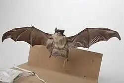
The yellow-bellied sheath-tailed bat (Saccolaimus flaviventris), also known as the yellow-bellied sheathtail or yellow-bellied pouched bat, is a microbat species of the family Emballonuridae found extensively in Australia and less commonly in parts of Papua New Guinea.
Although found throughout most parts of Australia, very little is known about its ecology due to the small size, nocturnal activity, and general elusiveness of most microbat species, making them difficult to study. They are sometimes mistaken for the endangered and less widely distributed bare-rumped sheathtail bat where the two species occur sympatrically, as well as other similar Emballonuridae species, but upon inspection are quite distinct and easily identified.
At present, the yellow-bellied sheath-tailed bat is the only member of the Microchiroptera that has been positively identified as a carrier of Australian bat lyssavirus. (Full article...) -
Agriculture in Papua New Guinea has more than a 7,000 years old history, and developed out of pre-agricultural plant/food collecting and cultivation traditions of local hunter-gatherers. Currently around 85% of Papua New Guinea's population lives from semi-subsistence agriculture. 86% of all food energy consumed in Papua New Guinea is locally sourced.
Papua New Guinea produces and exports agricultural, timber, and fish products. Agriculture in 2017 accounted for 22.1% of the GDP and supported more than 80% of the population. Cash crops ranked by value are coffee, oil, cocoa, copra, tea, rubber, and sugar. The timber industry was not active in 1998, due to low world prices, but rebounded in 1999. About 40% of the country is covered with timber rich trees, and a domestic woodworking industry has been slow to develop. 99% of fishing exports are either tuna or tuna byproduct. Papua New Guinea has the largest yam market in Asia. (Full article...) -
The Kina (ISO 4217 currency code: PGK, the currency symbol: K) is the currency of Papua New Guinea. It is divided into 100 toea. The name Kina is derived from Kuanua language of the Tolai region, referring to a callable pearl shell used widely for trading in both the Coastal and Highlands areas of the country. (Full article...)
-
Papua New Guinea is home to several protected areas, which receive protection because of their environmental, cultural or similar value.
The total area of Papua New Guinea protected territories is 14,330 km2 (5,530 sq mi), which amounts to approximately 3.07% of the country's territory. The total number of protected areas as 2018 is 71.
The effort by the PNG government to protect biodiversity has resulted in 44 existing terrestrial protected areas using the International Union for the Conservation of Nature and Natural Resources (IUCN) categories. These protected areas account for 1.6% of the total land area. A study of biodiversity identified a further 398 areas as candidates for conservation. This would increase the total protected areas to 16.8% of the total country area. (Full article...) -
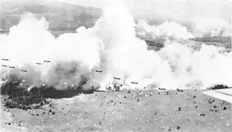
The Landing at Nadzab was an airborne landing on 5 September 1943 during the New Guinea campaign of World War II in conjunction with the landing at Lae. The Nadzab action began with a parachute drop at Lae Nadzab Airport, combined with an overland force.
The parachute drop was carried out by the US Army's 503rd Parachute Infantry Regiment and elements of the Australian Army's 2/4th Field Regiment into Nadzab, New Guinea in the Markham Valley, observed by General Douglas MacArthur, circling overhead in a B-17. The Australian 2/2nd Pioneer Battalion, 2/6th Field Company, and B Company, Papuan Infantry Battalion reached Nadzab after an overland and river trek that same day and began preparing the airfield. The first transport aircraft landed the next morning, but bad weather delayed the Allied build up. Over the next days, the 25th Infantry Brigade of the Australian 7th Division gradually arrived. An air crash at Jackson's Field ultimately caused half the Allied casualties of the battle.
Once assembled at Nadzab, the 25th Infantry Brigade commenced its advance on Lae. On 11 September, it engaged the Japanese soldiers at Jensen's Plantation. After defeating them, it engaged and defeated a larger Japanese force at Heath's Plantation. During this skirmish, Private Richard Kelliher won the Victoria Cross, Australia's highest award for gallantry. Instead of fighting for Lae, the Japanese Army withdrew over the Saruwaged Range. This proved to be a gruelling test of endurance for the Japanese soldiers who had to struggle over the rugged mountains; in the end, the Japanese Army managed to withdraw its forces from Salamaua and Lae, though with extensive losses from exposure and starvation during the retreat. Troops of the 25th Infantry Brigade reached Lae shortly before those of the 9th Division that had been advancing on Lae from the opposite direction. (Full article...) -
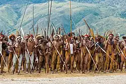
The indigenous peoples of Western New Guinea in Indonesia and Papua New Guinea, commonly called Papuans, are Melanesians. There is genetic evidence for two major historical lineages in New Guinea and neighboring islands: a first wave from the Malay Archipelago perhaps 50,000 years ago when New Guinea and Australia were a single landmass called Sahul and, much later, a wave of Austronesian people from the north who introduced Austronesian languages and pigs about 3,500 years ago. They also left a small but significant genetic trace in many coastal Papuan peoples.
Linguistically, Papuans speak languages from the many families of non-Austronesian languages that are found only on New Guinea and neighboring islands, as well as Austronesian languages along parts of the coast, and recently developed creoles such as Tok Pisin, Hiri Motu, Unserdeutsch, and Papuan Malay.
The term "Papuan" is used in a wider sense in linguistics and anthropology. In linguistics, "Papuan languages" is a cover term for the diverse, mutually unrelated, non-Austronesian language families spoken in Melanesia, the Torres Strait Islands, and parts of Wallacea. In anthropology, "Papuan" is often used to denote the highly diverse aboriginal populations of Melanesia and Wallacea prior to the arrival of Austronesian-speakers, and the dominant genetic traces of these populations in the current ethnic groups of these areas. (Full article...) -
Lorentz National Park is an Indonesian national park located in the provinces of Central Papua, Highland Papua and South Papua, in the southwest of western New Guinea. With an area of 25,056 km2 (9,674 mi2), it is the largest national park in Southeast Asia. In 1999 Lorentz was declared a World Heritage Site by UNESCO.
An outstanding example of the biodiversity of New Guinea, Lorentz is one of the most ecologically diverse national parks in the world. It is the only nature reserve in the Asia-Pacific region to contain a full altitudinal array of ecosystems ranging through marine areas, mangroves, tidal and freshwater swamp forest, lowland and montane rainforest, subalpine shrub and grassland, alpine tundra, and equatorial glaciers. At 4884 meters, Puncak Jaya (formerly Carstensz Pyramid) is the tallest mountain between the Himalayas and the Andes.
Birdlife International has called Lorentz Park "probably the single most important reserve in New Guinea". It contains five of World Wildlife Fund's "Global 200" ecoregions: Southern New Guinea Lowland Forests; New Guinea Montane Forests; New Guinea Central Range Subalpine Grasslands; New Guinea Mangroves; and New Guinea Rivers and Streams. (Full article...)
Did you know (auto-generated)

- ... that Australian official Jack Emanuel was awarded the George Cross in 1971 after being stabbed to death whilst trying to resolve a land dispute with the Tolai people of New Guinea?
- ... that in 1984, more than 10,000 Papuans from West Papua crossed into Papua New Guinea as refugees due to a government crackdown?
- ... that Australiformis semoni is a parasite that infests marsupials in Australia and New Guinea and whose infestation could cause debilitating ulcerative granulomatous gastritis?
- ... that David Dexter, who wrote the New Guinea volume in the series Australia in the War of 1939–1945, was a commando who served in East Timor and New Guinea?
- ... that artifacts of Papua New Guinean art were called "living spirits with fixed abodes"?
- ... that Dorkas Tokoro-Hanasbey, the only female member of the New Guinea Council, arrived thirty minutes late to her inauguration ceremony?
General images -
-
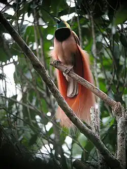
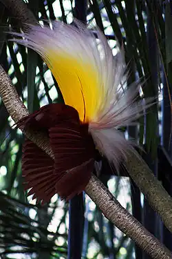 Paradisaea apoda, native to Papua, displaying its feathers (from Western New Guinea)
 -
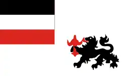 Flag under German control of New Guinea. (from History of Papua New Guinea)
 -
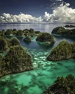
 Coral reefs in Papua New Guinea (from New Guinea)
 -
 Western New Guinea was formally annexed by Indonesia in 1969. (from New Guinea)
 -
.svg.png)
-
 Dutch colonial civil servant in the Baliem Valley, 1958 (from Western New Guinea)
 -
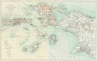 Dutch expeditions in Netherlands New Guinea 1907–1915. (from Western New Guinea)
 -
 Yali Mabel, Kurulu Village War Chief at Baliem Valley (from New Guinea)
 -
-
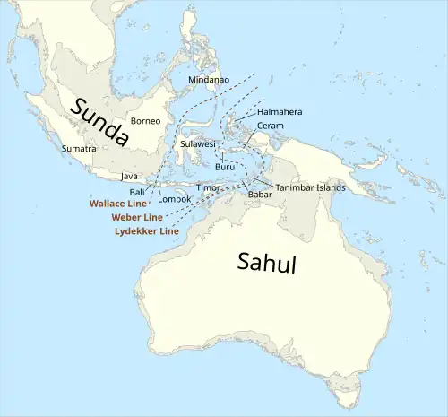 Map showing the combined landmass of Sahul formed during Pleistocene glacations (from New Guinea)
 -
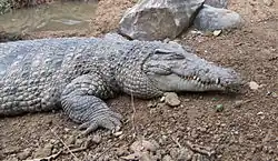 New Guinea crocodile (from New Guinea)
 -
 Hoisting the German flag at Mioko in 1884 (from History of Papua New Guinea)
 -
 Jayapura, the most populous and largest city on the island of New Guinea (Papua) (from New Guinea)
 -
-
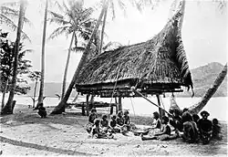
 Papuans on the Lorentz River, photographed during the third South New Guinea expedition in 1912–13 (from New Guinea)
 -
 The Sukarno-era West Irian Liberation Monument in Lapangan Banteng, Jakarta. (from Western New Guinea)
 -
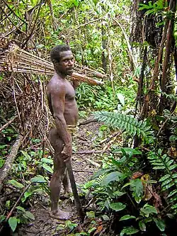
Korowai tribesman (from New Guinea)
-
 Koiari village near Bootless Inlet, British New Guinea (from History of Papua New Guinea)
 -

-
 Skouw border checkpoint, on the Indonesia-Papua New Guinea border (from Western New Guinea)
 -
 Papeda, a notable dish originating from Eastern Indonesia (from Western New Guinea)
 -
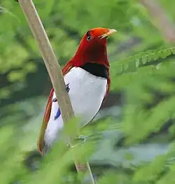 The king bird-of-paradise is one of over 300 bird species on the peninsula. (from Western New Guinea)
 -
.jpg) Australian forces attack Japanese positions during the Battle of Buna–Gona, 7 January 1943. (from History of Papua New Guinea)
Australian forces attack Japanese positions during the Battle of Buna–Gona, 7 January 1943. (from History of Papua New Guinea) -
 Group of natives at Mairy Pass. Mainland of British New Guinea in 1885. (from New Guinea)
 -
 Kerepunu women at the marketplace of Kalo, British New Guinea, 1885 (from History of Papua New Guinea)
 -
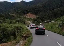 A section of Trans-Papua Highway connecting Deiyai and Mimika in Central Papua (from Western New Guinea)
 -
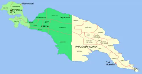 Political divisions of New Guinea (2006) (from New Guinea)
 -
 British flag raised in Queensland 1883 (from History of Papua New Guinea)
 -
 Fishing boats in Biak (from Western New Guinea)
 -
 An Australian soldier, Private George "Dick" Whittington, is aided by Papuan orderly Raphael Oimbari, near Buna on 25 December 1942. (from History of Papua New Guinea)
 -
 Handover ceremony of West Irian Governorship from Jan Bonay to Frans Kaisiepo, 1965 (from Western New Guinea)
 -
 Fort Du Bus in 1828 (from Western New Guinea)
 -
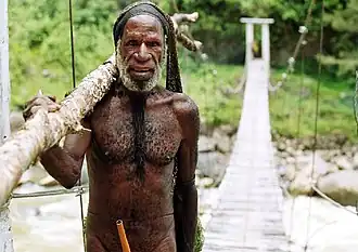
 Youtefa Bridge, currently the longest bridge in Papua (from Western New Guinea)
 -
.jpg)
-
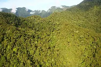
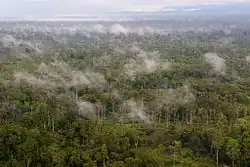 The lowland rainforest of the Western New Guinea (from Western New Guinea)
 -
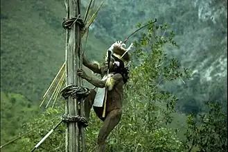
 Yali in the Yahukimo Regency (from Western New Guinea)
 -
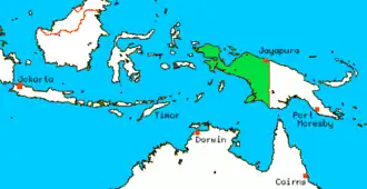
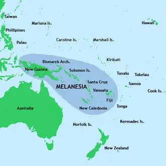 New Guinea located in relation to Melanesia (from New Guinea)
 -
 Papua New Guinea map of Köppen climate classification (from New Guinea)
 -
 The raggiana bird-of-paradise is native to New Guinea. (from New Guinea)
 -
 Female gable image, Sawos people, Oceanic art in the Bishop Museum (from History of Papua New Guinea)
 -
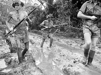
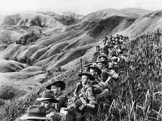 Australian soldiers resting in the Finisterre Ranges of New Guinea while en route to the front line (from New Guinea)
 -
 Regions of Oceania: Australasia, Polynesia, Micronesia, and Melanesia. Physiographically, Australasia includes the Australian landmass (including Tasmania), New Zealand, and New Guinea (from New Guinea)
 -
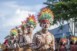 Culture parade in Biak (from Western New Guinea)
 -
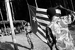 West Papuan separatists raising the Morning-Star flag in the jungles of Papua, 1971 (from Western New Guinea)
 -
 Australian troops at Milne Bay, Papua.The Australian garrison was the first to inflict defeat on the Imperial Japanese Army during World War II at the Battle of Milne Bay of Aug–Sep 1942. (from History of Papua New Guinea)
 -
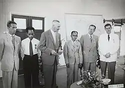 Dutch and Papuan officials during the opening of the Central Hospital in Hollandia, 1959 (from Western New Guinea)
 -
.png) New Guinea from 1884 to 1919. The Netherlands controlled the western half of New Guinea, Germany the north-eastern part, and Britain the south-eastern part. (from New Guinea)
New Guinea from 1884 to 1919. The Netherlands controlled the western half of New Guinea, Germany the north-eastern part, and Britain the south-eastern part. (from New Guinea) -
 Sago is a typical Papuan food, which is usually made into papeda. (from Western New Guinea)
 -
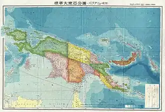
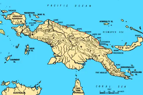 Map of New Guinea, with place names as used in English in the 1940s (from New Guinea)
 -
-
%252C_Pairi_daiza_2.jpg) Dorcopsis hageni, native to northern region of New Guinea. (from Western New Guinea)
Dorcopsis hageni, native to northern region of New Guinea. (from Western New Guinea) -
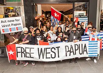 Free West Papua protest in Melbourne, Australia, August 2012. (from Western New Guinea)
 -
New Guinea from 1884 to 1919. Germany and Britain controlled the eastern half of New Guinea. (from History of Papua New Guinea)
-
![Image 54M.S. Rumagesan, Silas Papare, N.L.Suwages, Soegoro Atmoprasodjo [id], and A.H. Nasution in Putra-putra Irian Barat ('Sons of Irian Barat') Conference in Cibogo Bogor, 14–15 April 1961 (from Western New Guinea)](./_assets_/MS_Rumagesan%252C_Silas_Papare%252C_NL_Suwages%252C_Sugoro%252C_dan_AH_Nasution_berbincang-bincang%252C_Konferensi_Cibogo.jpg) M.S. Rumagesan, Silas Papare, N.L.Suwages, Soegoro Atmoprasodjo, and A.H. Nasution in Putra-putra Irian Barat ('Sons of Irian Barat') Conference in Cibogo Bogor, 14–15 April 1961 (from Western New Guinea)
M.S. Rumagesan, Silas Papare, N.L.Suwages, Soegoro Atmoprasodjo, and A.H. Nasution in Putra-putra Irian Barat ('Sons of Irian Barat') Conference in Cibogo Bogor, 14–15 April 1961 (from Western New Guinea) -
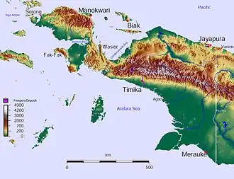
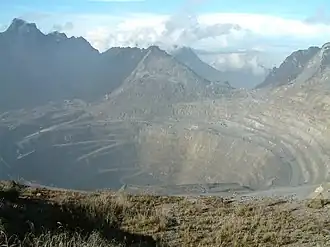 Grasberg Mine in Mimika Regency. Mining is the most important sector in the province (from Western New Guinea)
 -
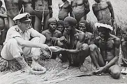
 Australian patrol officer in 1964 (from History of Papua New Guinea)
 -
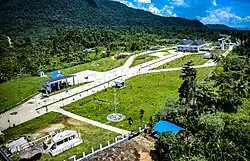
 Sentani International Airport in Jayapura is the principal point of entry to Papua (from Western New Guinea)
 -
 A 1644 map of New Guinea and the surrounding area (from New Guinea)
 -

-
 A Japanese military map of New Guinea from 1943 (from New Guinea)
 -
The continent of Sahul before the rising ocean sundered Australia and New Guinea after the last ice age (from New Guinea)
-
 The Nagarakertagama mentioned a region in the east called Wanin, present-day Onin Peninsula in the Fakfak Regency, West Papua (from Western New Guinea)
 -
 The floristic region of Malesia (from New Guinea)
 -
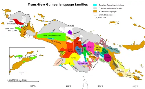 Trans-New Guinea languages (multi-coloured), Austronesian languages (gold), and other languages (grey) (from Western New Guinea)
 -
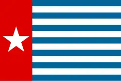 Since 2002, display of the flag of West Papua is allowed in West Papua only if accompanied by, and not raised higher than, the flag of Indonesia. (from Western New Guinea)
 -
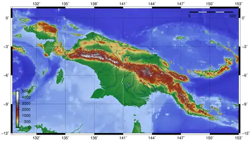 Topographical map of New Guinea (from New Guinea)
 -
Dutch expeditions in Netherlands New Guinea 1907–1915. (from Western New Guinea)
-
-
 The rugged and mountainous topography of Western New Guinea. (from Western New Guinea)
 -
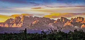
.jpg) Highlands of Papua New Guinea (from New Guinea)
Highlands of Papua New Guinea (from New Guinea) -
A typical map from the Golden Age of Netherlandish cartography. Australasia during the Golden Age of Dutch exploration and discovery (ca. 1590s–1720s): including Nova Guinea (New Guinea), Nova Hollandia (mainland Australia), Van Diemen's Land (Tasmania), and Nova Zeelandia (New Zealand). (from History of Papua New Guinea)
-
.jpg) New Guinea Volunteer Rifles with captured Japanese flag, 1942 (from History of Papua New Guinea)
New Guinea Volunteer Rifles with captured Japanese flag, 1942 (from History of Papua New Guinea) -
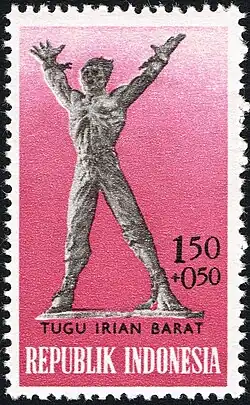
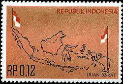 Rp 0.12 Indonesian stamp of 1963. (from Western New Guinea)
 -
Regions of Oceania: Australasia, Polynesia, Micronesia, and Melanesia. Australasia includes the Australian landmass (including Tasmania), New Zealand, and New Guinea. (from History of Papua New Guinea)
-
 Mount Bosavi (from New Guinea)
Related portals
WikiProjects
- WikiProject Papua New Guinea
- WikiProject Indonesia
- WikiProject Melanesia
General topics
Categories

Associated Wikimedia
The following Wikimedia Foundation sister projects provide more on this subject:
-
 Commons
Free media repository -
 Wikibooks
Free textbooks and manuals -
 Wikidata
Free knowledge base -
 Wikinews
Free-content news -
 Wikiquote
Collection of quotations -
 Wikisource
Free-content library -
 Wikiversity
Free learning tools -
 Wiktionary
Dictionary and thesaurus
External media
More portals
-
 List of all portals
 -

-

-

-
-

-

-

-

-

-
 Random portal
 -
 WikiProject Portals