2025 Alaska wildfires
| 2025 Alaska wildfires | |
|---|---|
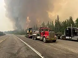 Bear Creek Fire from Park Highway on June 21, 2025. |
The 2025 Alaska wildfires are a series of active wildfires currently ongoing in Alaska.
Background
Alaska’s wildfire season is primarily driven by its boreal forest and tundra ecosystems, which can dry rapidly during the long summer days. The core fire season generally runs from late May through early August, peaking in June and July when extended daylight, low humidity, and warm temperatures combine with lightning activity to spark large fires. Many of the state’s largest recorded wildfires have occurred during this midsummer window.[1]
In interior Alaska, lightning-caused wildfires dominate, often in remote areas where suppression efforts are focused on protecting communities and infrastructure rather than full containment. In contrast, coastal regions see fewer large fires due to higher humidity and more frequent rainfall.[2]
While most wildfire activity is concentrated in summer, fires can occur as early as April or as late as September during unusually dry years. The Alaska Division of Forestry and Fire Protection issues burn permits for open debris burning from April 1 through August 31 in much of the state, with temporary suspensions during periods of high fire danger.[3]
List of wildfires
The following is a list of fires that burned more than 1,000 acres (400 ha), produced significant structural damage, or resulted in casualties.
| Name | County | Acres | Start date | Containment date[a] | Notes/References |
|---|---|---|---|---|---|
| Kathul | Southeast Fairbanks | 1,008 | May 25 | June 11 | [5] |
| Oskawalik | Bethel | 1,779 | June 14 | July 6 | [6] |
| Caribou | Yukon-Koyukuk | 1,936 | June 15 | August 2 | Caused by lightning.[7] |
| Hogatza | Yukon-Koyukuk | 29,044 | June 16 | Caused by lightning.[8] | |
| Kawichiark 1 | Northwest Arctic | 4,626 | June 16 | Caused by lightning.[9] | |
| Kawichiark 2 | Northwest Arctic | 2,667 | June 16 | Caused by lightning.[10] | |
| Telidaside | Yukon-Koyukuk | 1,733 | June 16 | [11] | |
| Chicken | Yukon-Koyukuk | 6,540 | June 16 | Caused by lightning.[12] | |
| Tetilesook | Northwest Arctic | 1,259 | June 16 | Caused by lightning.[13] | |
| Tagagawik | Yukon-Koyukuk | 1,378 | June 17 | Caused by lightning.[14] | |
| Wolf | Yukon-Koyukuk | 2,022 | June 17 | Caused by lightning.[15] | |
| Obrien | Yukon-Koyukuk | 8,125 | June 17 | Caused by lightning.[16] | |
| HelpMeJack | Yukon-Koyukuk | 3,182 | June 17 | Caused by lightning.[17] | |
| Chabanika | Yukon-Koyukuk | 3,893 | June 17 | Caused by lightning.[18] | |
| Kalusuk | Northwest Arctic | 1,062 | June 17 | Caused by lightning.[19] | |
| Klikhtentotzna | Yukon-Koyukuk | 79,795 | June 17 | Caused by lightning.[20] | |
| Kandik | Southeast Fairbanks | 5,328 | June 18 | Caused by lightning.[21] | |
| Meadow Creek | Yukon-Koyukuk | 19,634 | June 18 | Caused by lightning.[22] | |
| Kechumstuk Creek | Southeast Fairbanks | 12,604 | June 18 | Caused by lightning.[23] | |
| Boulder Creek | Fairbanks North Star | 4,056 | June 18 | Caused by lightning.[24] | |
| Orum | Yukon-Koyukuk | 5,647 | June 18 | Caused by lightning.[25] | |
| Lush | Yukon-Koyukuk | 26,544 | June 18 | [26] | |
| Williams | Yukon-Koyukuk | 1,180 | June 18 | Caused by lightning.[27] | |
| Aniralik | Northwest Arctic | 4,906 | June 19 | Caused by lightning.[28] | |
| Twelvemile Lake | Southeast Fairbanks | 23,627 | June 19 | Caused by lightning.[29] | |
| Ricks Creek | Fairbanks North Star | 16,720 | June 19 | Caused by lightning.[30] | |
| Ninetyeight | Fairbanks North Star | 15,610 | June 19 | Caused by lightning.[31] | |
| Himalaya Road | Fairbanks North Star | 6,194 | June 19 | Caused by lightning.[32] | |
| Bear Creek | Denali | 30,988 | June 19 | Caused by lightning. 9 reported residences destroyed.[33] | |
| Moran | Yukon-Koyukuk | 10,805 | June 19 | [34] | |
| Bonnifield Creek | Denali | 16,219 | June 19 | Caused by lightning. 6 reported residences destroyed.[35] | |
| Bonanza Creek | Fairbanks North Star | 12,556 | June 19 | Caused by lightning.[36] | |
| Nelchina Glacier | Matanuska-Susitna | 3,920 | June 19 | [37] | |
| 7 Mile Lookout | Southeast Fairbanks | 3,917 | June 19 | Caused by lightning.[38] | |
| Susulatna | Yukon-Koyukuk | 3,031 | June 19 | Caused by lightning.[39] | |
| Nowitna | Yukon-Koyukuk | 2,613 | June 19 | Caused by lightning.[40] | |
| Elephant | Yukon-Koyukuk | 8,941 | June 19 | Caused by lightning.[41] | |
| Red | Yukon-Koyukuk | 9,174 | June 19 | Caused by lightning.[42] | |
| Ikheenjik | Yukon-Koyukuk | 18,458 | June 20 | [43] | |
| Turtle | Yukon-Koyukuk | 16,322 | June 20 | [44] | |
| Moldy | Yukon-Koyukuk | 72,431 | June 20 | Caused by lightning.[45] | |
| McArthur Creek | Southeast Fairbanks | 7,123 | June 20 | Caused by lightning.[46] | |
| Ridgeline | Southeast Fairbanks | 4,755 | June 20 | [47] | |
| River Trail | Southeast Fairbanks | 22,907 | June 20 | Caused by lightning.[48] | |
| Porphyry | Southeast Fairbanks | 2,641 | June 20 | Caused by lightning.[49] | |
| Takoma | Yukon-Koyukuk | 19,431 | June 20 | Caused by lightning.[50] | |
| Birch | Yukon-Koyukuk | 4,739 | June 20 | Caused by lightning.[51] | |
| Goldstream Creek | Yukon-Koyukuk | 20,551 | June 20 | [52] | |
| Saint George Creek | Denali | 25,992 | June 20 | Caused by lightning. 4 reported residences destroyed.[53] | |
| Fish Lake | Copper River | 1,841 | June 20 | Caused by lightning.[54] | |
| Buckley Bar | Yukon-Koyukuk | 9,382 | June 20 | Caused by lightning.[55] | |
| Dry Creek | Denali | 12,043 | June 20 | Caused by lightning.[56] | |
| Aggie Creek | Fairbanks North Star | 35,146 | June 20 | Caused by lightning.[57] | |
| Live Trap | Denali | 2,503 | June 20 | Caused by lightning.[58] | |
| Christian | Yukon-Koyukuk | 34,161 | June 20 | Caused by lightning.[59] | |
| Michigan | Yukon-Koyukuk | 1,534 | June 20 | Caused by lightning.[60] | |
| Salmon Trout | Yukon-Koyukuk | 1,303 | June 20 | Caused by lightning.[61] | |
| Susulatna Hills | Yukon-Koyukuk | 8,711 | June 20 | Caused by lightning.[62] | |
| Pilot Creek | Yukon-Koyukuk | 3,694 | June 20 | Caused by lightning.[63] | |
| Sand Lake | Southeast Fairbanks | 6,293 | June 21 | [64] | |
| Yellow | Yukon-Koyukuk | 7,830 | June 21 | Caused by lightning.[65] | |
| Kerulu | Northwest Arctic | 1,645 | June 21 | Caused by lightning.[66] | |
| Ikpikpuk | North Slope | 1,995 | June 22 | Caused by lightning.[67] | |
| Monte Cristo Creek | Fairbanks North Star | 6,758 | June 22 | Caused by lightning.[68] | |
| Three Castle | Southeast Fairbanks | 1,954 | June 23 | Caused by lightning.[69] | |
| Runt | Yukon-Koyukuk | 16,089 | June 23 | Caused by lightning.[70] | |
| Mauneluk | Northwest Arctic | 2,786 | June 25 | Caused by lightning.[71] | |
| Tsukon | Yukon-Koyukuk | 1,319 | July 4 | Caused by lightning.[72] | |
| Wheeler | Yukon-Koyukuk | 26,698 | July 7 | Caused by lightning.[73] | |
| Portage | Yukon-Koyukuk | 1,212 | July 7 | Caused by lightning.[74] | |
| Kaliguricheark | Northwest Arctic | 8,714 | July 7 | Caused by lightning.[75] | |
| Nuna | Northwest Arctic | 16,369 | July 7 | Caused by lightning.[76] | |
| Reed | Northwest Arctic | 1,662 | July 9 | Caused by lightning.[77] |
See also
- 2025 United States wildfires
- 2025 Arizona wildfires
- 2025 Arkansas wildfires
- 2025 California wildfires
- 2025 Colorado wildfires
- 2025 Florida wildfires
- 2025 Idaho wildfires
- 2025 Kansas wildfires
- 2025 Louisiana wildfires
- 2025 Minnesota wildfires
- 2025 Mississippi wildfires
- 2025 Missouri wildfires
- 2025 Montana wildfires
- 2025 Nebraska wildfires
- 2025 Nevada wildfires
- 2025 New Mexico wildfires
- 2025 North Carolina wildfires
- 2025 North Dakota wildfires
- 2025 Oklahoma wildfires
- 2025 Oregon wildfires
- 2025 South Carolina wildfires
- 2025 South Dakota wildfires
- 2025 Tennessee wildfires
- 2025 Texas wildfires
- 2025 Utah wildfires
- 2025 Washington wildfires
- 2025 Wyoming wildfires
Notes
- ^ Containment means that fire crews have established and secured control lines around the fire's perimeter. These lines are artificial barriers, like trenches or cleared vegetation, designed to stop the fire's spread, or natural barriers like rivers. Containment reflects progress in managing the fire but does not necessarily mean the fire is starved of fuel, under control, or put out.[4]
References
- ^ "Wildland Fire in Alaska". Alaska Wildland Fire Information. Retrieved August 15, 2025.
- ^ "Alaska's Fire Seasons". Alaska Department of Environmental Conservation. Retrieved August 15, 2025.
- ^ "Burn Permits in Alaska". Alaska Department of Natural Resources. Retrieved August 15, 2025.
- ^ "What containment and other wildfire related terms mean". Los Angeles: KCAL-TV. September 12, 2024. Retrieved July 25, 2025.
- ^ "Kathul - Wildfire and Smoke Map". cincinnati.com. Retrieved May 29, 2025.
- ^ "Oskawalik - Wildfire and Smoke Map". USAToday. Retrieved June 16, 2025.
- ^ "Caribou - Wildfire and Smoke Map". The Oklahoman. Retrieved June 20, 2025.
- ^ "Hogatza - Wildfire and Smoke Map". USAToday. Retrieved June 17, 2025.
- ^ "Kawichiark 1 - Wildfire and Smoke Map". The Oklahoman. Retrieved June 19, 2025.
- ^ "Kawichiark 2 - Wildfire and Smoke Map". The Oklahoman. Retrieved June 19, 2025.
- ^ "Telidaside - Wildfire and Smoke Map". USAToday. Retrieved June 24, 2025.
- ^ "Chicken - Wildfire and Smoke Map". The Oklahoman. Retrieved July 4, 2025.
- ^ "Tetilesook - Wildfire and Smoke Map". The Oklahoman. Retrieved July 4, 2025.
- ^ "Tagagawik - Wildfire and Smoke Map". The Oklahoman. Retrieved June 19, 2025.
- ^ "Wolf - Wildfire and Smoke Map". USAToday. Retrieved June 20, 2025.
- ^ "Obrien - Wildfire and Smoke Map". The Oklahoman. Retrieved July 6, 2025.
- ^ "HelpMeJack - Wildfire and Smoke Map". USAToday. Retrieved June 20, 2025.
- ^ "Chabanika - Wildfire and Smoke Map". USAToday. Retrieved June 20, 2025.
- ^ "Kalusuk - Wildfire and Smoke Map". The Oklahoman. Retrieved July 4, 2025.
- ^ "Klikhtentotzna - Wildfire and Smoke Map". The Oklahoman. Retrieved July 4, 2025.
- ^ "Kandik - Wildfire and Smoke Map". The Oklahoman. Retrieved June 22, 2025.
- ^ "Meadow Creek - Wildfire and Smoke Map". The Oklahoman. Retrieved July 4, 2025.
- ^ "Kechumstuk Creek - Wildfire and Smoke Map". The Oklahoman. Retrieved June 20, 2025.
- ^ "Boulder Creek - Wildfire and Smoke Map". USAToday. Retrieved June 22, 2025.
- ^ "Orum - Wildfire and Smoke Map". USAToday. Retrieved June 20, 2025.
- ^ "Lush - Wildfire and Smoke Map". USAToday. Retrieved June 24, 2025.
- ^ "Williams - Wildfire and Smoke Map". The Oklahoman. Retrieved July 4, 2025.
- ^ "Aniralik - Wildfire and Smoke Map". The Oklahoman. Retrieved June 20, 2025.
- ^ "Twelvemile Lake - Wildfire and Smoke Map". The Oklahoman. Retrieved June 20, 2025.
- ^ "Ricks Creek - Wildfire and Smoke Map". USAToday. Retrieved June 24, 2025.
- ^ "Ninetyeight - Wildfire and Smoke Map". USAToday. Retrieved June 20, 2025.
- ^ "Himalaya Road - Wildfire and Smoke Map". The Oklahoman. Retrieved June 20, 2025.
- ^ "Bear Creek - Wildfire and Smoke Map". The Oklahoman. Retrieved June 20, 2025.
- ^ "Moran - Wildfire and Smoke Map". The Oklahoman. Retrieved June 22, 2025.
- ^ "Bonnifield Creek - Wildfire and Smoke Map". The Oklahoman. Retrieved June 22, 2025.
- ^ "Bonanza Creek - Wildfire and Smoke Map". The Oklahoman. Retrieved June 22, 2025.
- ^ "Nelchina Glacier - Wildfire and Smoke Map". The Oklahoman. Retrieved June 22, 2025.
- ^ "7 Mile Lookout - Wildfire and Smoke Map". The Oklahoman. Retrieved July 1, 2025.
- ^ "Susulatna - Wildfire and Smoke Map". The Oklahoman. Retrieved July 4, 2025.
- ^ "Nowitna - Wildfire and Smoke Map". The Oklahoman. Retrieved July 4, 2025.
- ^ "Elephant - Wildfire and Smoke Map". The Oklahoman. Retrieved July 16, 2025.
- ^ "Red - Wildfire and Smoke Map". The Oklahoman. Retrieved July 16, 2025.
- ^ "Ikheenjik - Wildfire and Smoke Map". USAToday. Retrieved June 22, 2025.
- ^ "Turtle - Wildfire and Smoke Map". USAToday. Retrieved June 22, 2025.
- ^ "Moldy - Wildfire and Smoke Map". USAToday. Retrieved June 22, 2025.
- ^ "McArthur Creek - Wildfire and Smoke Map". The Oklahoman. Retrieved June 22, 2025.
- ^ "Ridgeline - Wildfire and Smoke Map". The Oklahoman. Retrieved June 24, 2025.
- ^ "River Trail - Wildfire and Smoke Map". The Oklahoman. Retrieved June 24, 2025.
- ^ "Porphyry - Wildfire and Smoke Map". The Oklahoman. Retrieved June 24, 2025.
- ^ "Takoma - Wildfire and Smoke Map". USAToday. Retrieved June 24, 2025.
- ^ "Birch - Wildfire and Smoke Map". USAToday. Retrieved June 24, 2025.
- ^ "Goldstream Creek - Wildfire and Smoke Map". USAToday. Retrieved June 24, 2025.
- ^ "Saint George Creek - Wildfire and Smoke Map". The Oklahoman. Retrieved June 24, 2025.
- ^ "Fish Lake - Wildfire and Smoke Map". The Oklahoman. Retrieved July 1, 2025.
- ^ "Buckley Bar - Wildfire and Smoke Map". The Oklahoman. Retrieved July 1, 2025.
- ^ "Dry Creek - Wildfire and Smoke Map". The Oklahoman. Retrieved July 1, 2025.
- ^ "Aggie Creek - Wildfire and Smoke Map". The Oklahoman. Retrieved July 4, 2025.
- ^ "Live Trap - Wildfire and Smoke Map". The Oklahoman. Retrieved July 4, 2025.
- ^ "Christian - Wildfire and Smoke Map". The Oklahoman. Retrieved July 4, 2025.
- ^ "Michigan - Wildfire and Smoke Map". The Oklahoman. Retrieved July 4, 2025.
- ^ "Salmon Trout - Wildfire and Smoke Map". The Oklahoman. Retrieved July 4, 2025.
- ^ "Susulatna Hills - Wildfire and Smoke Map". The Oklahoman. Retrieved July 4, 2025.
- ^ "Pilot Creek - Wildfire and Smoke Map". The Oklahoman. Retrieved July 4, 2025.
- ^ "Sand Lake - Wildfire and Smoke Map". The Oklahoman. Retrieved June 24, 2025.
- ^ "Yellow - Wildfire and Smoke Map". The Oklahoman. Retrieved July 4, 2025.
- ^ "Kerulu - Wildfire and Smoke Map". The Oklahoman. Retrieved July 4, 2025.
- ^ "Ikpikpuk - Wildfire and Smoke Map". The Oklahoman. Retrieved July 4, 2025.
- ^ "Monte Cristo Creek - Wildfire and Smoke Map". The Oklahoman. Retrieved July 6, 2025.
- ^ "Three Castle - Wildfire and Smoke Map". The Oklahoman. Retrieved July 1, 2025.
- ^ "Runt - Wildfire and Smoke Map". The Oklahoman. Retrieved July 4, 2025.
- ^ "Maneuluk - Wildfire and Smoke Map". The Oklahoman. Retrieved July 16, 2025.
- ^ "Tsukon - Wildfire and Smoke Map". The Oklahoman. Retrieved July 16, 2025.
- ^ "Wheeler - Wildfire and Smoke Map". The Oklahoman. Retrieved July 16, 2025.
- ^ "Portage - Wildfire and Smoke Map". The Oklahoman. Retrieved July 16, 2025.
- ^ "Kaliguricheark - Wildfire and Smoke Map". The Oklahoman. Retrieved July 16, 2025.
- ^ "Nuna - Wildfire and Smoke Map". The Oklahoman. Retrieved July 16, 2025.
- ^ "Reed - Wildfire and Smoke Map". The Oklahoman. Retrieved July 16, 2025.
| Africa | South Africa (Cape Town) | ||||||
|---|---|---|---|---|---|---|---|
| Asia |
| ||||||
| Europe | |||||||
| North America |
| ||||||
| South America | |||||||
| |||||||