2025 Montana wildfires
| 2025 Montana wildfires | |
|---|---|
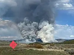 Smoke from the Sawlog Fire on May 3 | |
| Season | |
← 2024 |
There is an ongoing series of wildfires burning throughout the U.S. state of Montana.
Background
While "fire season" in Montana varies every year based on weather conditions, most wildfires occur in between May and October. Wildfires are influenced by above average temperatures and dry conditions that influence drought. When vegetation dries out earlier in the season, wildfires are more likely to start and spread. The leading cause of wildfires in Montana is burning debris.[1] The spread rate of wildfires is affected by the buildup of fuels.[2]
Summary
Despite a worsening drought, the number of acres burned in Montana by July 24 was significantly less than land managers expected. While there had been a similar number of starts compared to last year, (1,116 on July 21, 2025 with 1,069 one year prior), there had been significantly less area burned (92,000 acres (37,000 ha) on July 21, 2024 compared to just 17,000 acres (6,900 ha) the same time in 2025). This was mostly due to heavy-precipitation storms coming from Northwest United States. It moistened terrain, making it less favorable to fire spread. Storms hit areas that needed moisture.[3] However, officials remained the most concerned for Bitterroot Valley from forest fuels and inaccessible terrain, Gallatin, Madison, and Jefferson counties due to population growth, the Central Montana grasslands due to grass fuels, and the Eastern plains due to heavy grass growth.[4] Main fire concerns are hot temperatures.[3]
List of wildfires
The following is a list of fires that burned more than 1,000 acres (400 ha), or produced significant structural damage or casualties.
| Name | County | Acres | Start date | Containment date[a] | Notes | Ref |
|---|---|---|---|---|---|---|
| Sawlog | Beaverhead | 2,030 | May 1 | May 19 | Undetermined cause. Burned 15 miles (24 km) northeast of Wisdom. Cost $2.5 million in suppression. | [6][7] |
| Wilder | Fergus | 3,450 | July 2 | July 22 | Lightning-caused. Burned 27 miles (43 km) northeast of Roy. | [8][9] |
| Tullock | Big Horn | 1,469 | August 4 | August 8 | Unknown cause. Burned 13 miles (21 km) northeast of Hardin. | [10] |
| Mission Butte | Big Horn | 6,149 | August 11 | Unknown cause. Burning 3 miles (4.8 km) east of St. Xavier. | [11] | |
| Summer Springs | Treasure County | 2,568 | August 13 | Unknown cause. Burning 13 miles (21 km) southeast of Custer. | [12] | |
| Pony Creek | Rosebud | 1,062 | August 13 | August 15 | Lightning-caused. Burned 4 miles (6.4 km) east of Colstrip. | [13][14] |
| Horn | Madison | 2,800 | August 13 | Unknown cause. Burning 17 miles (27 km) northwest of West Yellowstone and prompting pre-evacuations near Madison River Ranch. | [15][16] | |
| Bivens Creek | Madison | 2,060 | August 13 | Unknown cause. Burning 10 miles (16 km) east of Sheridan. | [17][18] | |
| Cloudrest | Madison | 1,183 | August 14 | Unknown cause. Burning west of Twin Bridges. | [17][19] | |
| McAllister | Madison | 3,500 | August 16 | Unknown cause. Burning 4 miles (6.4 km) north of McAllister. | [20] | |
| Moser Dome | Yellowstone | 1,189 | August 18 | Burning north of Silesia near the Yellowstone/Carbon county line. | [21] |
See also
- 2025 Canadian wildfires
- 2025 Idaho wildfires
- 2025 North Dakota wildfires
- 2025 South Dakota wildfires
- 2025 United States wildfires
- 2025 Wyoming wildfires
- Wildfires in 2025
Notes
- ^ Containment means that fire crews have established and secured control lines around the fire's perimeter. These lines are artificial barriers, like trenches or cleared vegetation, designed to stop the fire's spread, or natural barriers like rivers. Containment reflects progress in managing the fire but does not necessarily mean the fire is starved of fuel, under control, or put out.[5]
References
- ^ "Montana Fire Season: In-Depth Guide". wfca.com. Western Fire Chiefs Association. Retrieved April 29, 2025.
- ^ "A New Approach to Montana Wildfires". wildmontana.org. Wild Montana. Retrieved April 29, 2025.
- ^ a b Walden, Leigh (July 24, 2025). "This year's wildfire season has been chill so far. Why?". montanafreepress.org. Retrieved August 13, 2025.
- ^ Clements, Bobby (August 5, 2025). "It's wildfire season: Awareness, preparedness, and prevention". www.montanarightnow.com. KTMF. Retrieved August 13, 2025.
- ^ "What containment and other wildfire related terms mean". Los Angeles: KCAL-TV. September 12, 2024. Retrieved July 25, 2025.
- ^ "Sawlog Fire Information". InciWeb. Archived from the original on May 20, 2025. Retrieved August 5, 2025.
- ^ "Sawlog - Wildfire and Smoke Map". data.gosanangelo.com. Retrieved August 5, 2025.
- ^ "Wilder - Wildfire and Smoke Map". data.pnj.com. Retrieved August 5, 2025.
- ^ "Wilder Fire in Fergus County grows to 3,400 acres". KRTV. July 5, 2025. Retrieved August 5, 2025.
- ^ "Tullock - Wildfire and Smoke Map". data.dispatch.com. Retrieved August 5, 2025.
- ^ "Mission Butte - Wildfire and Smoke Map". data.usatoday.com. Retrieved August 18, 2025.
- ^ "Summer Springs - Wildfire and Smoke Map". data.usatoday.com. Retrieved August 14, 2025.
- ^ "Pony Creek - Wildfire and Smoke Map". data.usatoday.com. Retrieved August 14, 2025.
- ^ "Pony Creek Fire near Colstrip, 1,000 acres big, is 100% contained". KULR. August 15, 2025. Retrieved August 15, 2025.
- ^ "LG25 6395 - Horn - Wildfire and Smoke Map". data.usatoday.com. Retrieved August 14, 2025.
- ^ "Horn Fire burning south of Cliff Lake". KBZK. August 14, 2025. Retrieved August 14, 2025.
- ^ a b "Madison Co. Fires: Cloudrest and Bivens Creek fires top 1K acres". KBZK. August 16, 2025. Retrieved August 16, 2025.
- ^ "Bivens Creek - Wildfire and Smoke Map". data.usatoday.com. Retrieved August 18, 2025.
- ^ "Cloudrest - Wildfire and Smoke Map". data.columbiadialyherald.com. Retrieved August 18, 2025.
- ^ "McAllister - Wildfire and Smoke Map". data.statesmanjournal.com. Retrieved August 18, 2025.
- ^ "New wildfire sparks north of Silesia". KTVQ. August 18, 2025. Retrieved August 18, 2025.
| Africa | South Africa (Cape Town) | ||||||
|---|---|---|---|---|---|---|---|
| Asia |
| ||||||
| Europe | |||||||
| North America |
| ||||||
| South America | |||||||
| |||||||
Montana wildfires | |
|---|---|
| Pre-2000 | |
| 2017 | |
| 2018 | |
| 2021 |
|
| 2022 |
|
| |